Hundreds flee homes after Mt. Kinabalu floods
KOTA KINABALU — Tons of mud, boulders, rocks and debris flowed down Mount Kinabalu after three days of heavy rain, forcing the evacuation of hundreds of people from their homes at the foothills of the mountain.
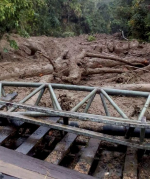
The mudflows – after the June 5 earthquake – hit Mesilau on the eastern face and Kiau on the western side, washing out and seriously damaging bridges as firemen began rescue operations in affected villages.
The mudflows began at about 3 p.m. Monday, blocking roads into Kiau and Mesilau, which is one of Sabah’s key highland vegetable-growing areas.
Farmer Jassumiah Jati said she was among dozens of villagers from Kampung Mesilau who fled their homes after seeing huge boulders being carried down by fast-flowing mud in the river near them.
“It was scary to hear those boulders crashing down with the mud,” she said, adding that they barely made it out of the Mesilau area before the bridges were damaged.
Article continues after this advertisement“Many are still unable to come out because the bridges have been washed away and they fear that mudslides will flow into their areas,” Jassumiah said.
Article continues after this advertisementPolice and firemen stopped anyone from entering the Mesilau area and were trying to help evacuate those stranded there. As at 9:30 p.m., some 100 villagers had been evacuated on the order of the Ranau district officer.

Dangerous crossing: A bridge was destroyed during muddy floods at Sg Mesilau in Kundasang. The Star/Asia News Network
Sabah Fire and Rescue Department chief Affendy Ramin said they evacuated four people while others who made it out from Mesilau were putting up with friends or relatives.
Hundreds fled the Mesilau area after mudslides flowed down on the eastern face of Mount Kinabalu. The mountain was hit by a magnitude 5.9 earthquake on June 5.
Mesilau is also the location of the Kinabalu Parks Mesilau nature centre, located adjacent to a resort.
Numerous holiday chalets, homestays and the Mount Kinabalu Golf Club are located at Mesilau.
Roads leading to the nature center and the golf club were among those cut off.
The mudslides also flowed into Kampung Kiau Taburi, Naulu and Bersatu apart from Lobong-Lobong, and Kg Kaung on the western side of the mountain.

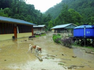
Covered in mud: SK Kiau Taburi in Kota Belud was also hit by flash floods. The Star/Asia News Network
The SK Kiau Taburi was also hit by mudslides, although immediate damage could not be ascertained.
Some families have moved out of their houses, while both the Kota Belud and Ranau district offices had activated their natural disaster operations centres.
In Kampung Kiau, Kampung Lobong-Lobong and Kampung Kaung at the foothills on the western side of the mountain, boulders and mudslides have come down during the past 10 days.
Over the past few weeks, villagers have been reporting fish dying en masse due to the high mineral content in the rivers after the earthquake.
They have also heard rocks falling from the mountain during the nearly 60 aftershocks.
The biggest of these, which measured 5.1 on the Richter scale, happened on Saturday.
RELATED STORIES
Quake forms new, safer trail to Mt. Kinabalu
Nudist on Mt. Kinabalu dismisses local culture as superstition