Possible LPA east of Mindanao could enter PH by Monday—Pagasa
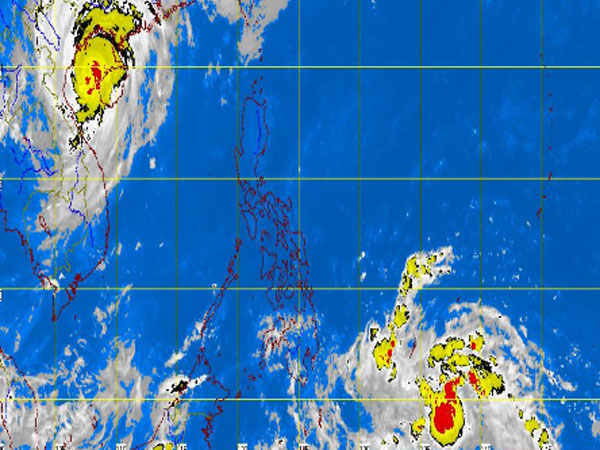
MANILA, Philippines — A potential low pressure area east of Mindanao could enter the Philippines by Monday, the state weather bureau said Sunday.
The possible LPA has a “50-50” chance of becoming a cyclone, Jori Loiz of the Philippine Atmospheric Geophysical and Astronomical Services Administration said.
It is threatening to track through the same path of supertyphoon “Yolanda” (international name Haiyan), US-based weather service Accuweather.com said.
“A tropical disturbance spinning north of Papua New Guinea is expected to track through the Philippines in a very similar fashion to Haiyan at midweek,” Kristina Pydynowski, a senior meteorologist from Accuweather.com said.
But the “good news,” she noted, was that the winds within the system “will be significantly weaker than in Haiyan when it reaches the Philippines.”
Article continues after this advertisementBut the passing rainshowers and thunderstorms could hinder relief and rescue efforts.
Article continues after this advertisementParts of the country, most especially the Visayas region, is still recovering from the monster-typhoon, dubbed as the strongest typhoon in the world this year and at the same time is also one of the strongest in history.
AccuWeather.com meteorologist Eric Wanenchak predicted a general 100 to 200 mm (4 to 8 inches) of rain will fall along the path of the system.
This amount of rain could easily trigger new flash flooding problems, especially with the ground severely saturated by Haiyan.
Pydynowski said the tropical disturbance will not be traveling as fast as Haiyan, meaning there will be more time for heavy rain to pour down.
Although Pagasa did not confirm the Accuweather.com’s report, it said that there was a possibility that the LPA could be of the same path of Yolanda.
RELATED STORIES:
Chaos, dead bodies on typhoon-ravaged streets of Tacloban City
10,000 feared dead in typhoon-hit Philippine province – police
151 killed by ‘Yolanda’; 4.5M people affected – NDRRMC
120 policemen deployed to prevent looting in Tacloban City
