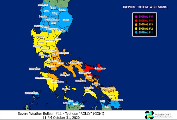
Northern Albay under Signal No. 4 as Rolly moves closer to Catanduanes

Image from PAGASA
MANILA, Philippines —Tropical Cyclone Weather Signal (TCWS) No. 4 was hoisted over the northern portion of Albay as Typhoon Rolly (international name: Goni) got nearer Catanduanes, the Philippine Atmospheric, Geophysical and Astronomical Services Administration (Pagasa) said in its 11 p.m. bulletin on Saturday.
Following are the other areas in Bicol earlier put under Signal No. 4:
Catanduanes
the eastern portion of Camarines Sur (Buhi, Iriga City, Baao, Pili, Naga City, Bombon, Calabanga, Ocampo, Sagnay, Tigaon, Goa, Tinambac, Siruma, Lagonoy, Garchitorena, San Jose, Presentacion, Caramoan)
the northern portion of Albay (Tiwi, Polangui, Malinao, Tabaco City, Malilipot, Bacacay, Rapu-Rapu).
Article continues after this advertisementHere are areas under Signal No. 3:
Article continues after this advertisementLUZON
Camarines Norte
the rest of Camarines Sur
the rest of Albay
Burias and Ticao Islands
Sorsogon
Quezon
Laguna
Rizal
the eastern portion of Batangas (Tanauan City, Santo Tomas, Malvar, Balete, Mataas Na Kahoy, Lipa City, Cuenca, Talisay, San Nicolas, Santa Teresita, Alitagtag, San Pascual, Batangas City, San Jose, Ibaan, Taysan, Lobo, Padre Garcia, Rosario, San Juan)
Marinduque
the northern portion of Oriental Mindoro (Puerto Galera, San Teodoro, Baco, Calapan City, Naujan, Victoria, Pola, Socorro, Pinamalayan)
the northern portion of Romblon (Concepcion, Banton, Corcuera)
VISAYAS
Northern Samar
Following are the areas under Signal No. 2:
LUZON
The rest of Masbate
the rest of Romblon
the rest of Oriental Mindoro
Occidental Mindoro including Lubang Island
the rest of Batangas, Cavite
Metro Manila
Bulacan
Pampanga
Bataan
Zambales
Tarlac
Nueva Ecija
the central and southern portion of Aurora (Dipaculao, Maria Aurora, Baler, San Luis, Dingalan), the southern portion of Quirino (Nagtipunan)
the southern portion of Nueva Vizcaya (Alfonso Castaneda, Dupax Del Norte, Dupax Del Sur)
Pangasinan
VISAYAS
The northern portion of Samar (Catbalogan City, Jiabong, Motiong, Paranas, Hinabangan, San Sebastian, Tarangnan, Pagsanghan, San Jorge, San Jose de Buan, Matuguinao, Gandara, Santa Margarita, Calbayog City, Santo Nino, Almagro, Tagapul-An)
the northern portion of Eastern Samar (San Julian, Sulat, Taft, Can-Avid, Dolores, Maslog, Oras, San Policarpo, Arteche, Jipapad), the extreme northern portion of Antique (Pandan, Libertad, Caluya)
the northwestern portion of Aklan (Buruanga, Malay, Nabas, Ibajay)
Following are the areas under Signal No. 1:
LUZON
the southern portion of Cagayan (Peñablanca, Iguig, Rizal, Piat, Tuao, Solana, Tuguegarao City, Enrile)
Isabela
the rest of Quirino
the rest of Nueva Vizcaya
the southern portion of Apayao (Conner)
Kalinga
Abra
Mountain Province
Ifugao
Benguet
the southern portion of Ilocos Norte (Nueva Era, Dingras, Sarrat, San Nicolas, Laoag City, Paoay, Currimao, Badoc, Pinili, Batac City, Banna, Marcos)
Ilocos Sur
La Union
the rest of Aurora
Calamian Islands
VISAYAS
the rest of the northern portion of Antique (Sebaste, Culasi)
the rest of Aklan
the northern portion of Capiz (Jamindan, Mambusao, Sapi-An, Ivisan, Roxas City, Panay, Pilar, Sigma, Dao, Panitan, Pontevedra, President Roxas)
the northern portion of Iloilo (Carles, Balasan, Estancia, Batad)
Biliran
the northern portion of Leyte (Leyte, Tabango, San Isidro, Calubian, Capoocan, Carigara, Tunga, Barugo, San Miguel, Babatngon, Tacloban City)
the rest of Samar
the rest of Eastern Samar
The typhoon is predicted to hit the country’s landmass on Sunday morning, Pagasa said.
It will bring intense rains over Catanduanes this Saturday night through Sunday morning.
“The center of the eye of Typhoon ‘ROLLY’ is forecast to make landfall at or near its current peak intensity over Catanduanes tomorrow early morning and over Camarines Sur tomorrow morning. Afterwards, the center will cross the Camarines Provinces before heading towards mainland Quezon tomorrow afternoon,” Pagasa said.
Pagasa also warned that intense rains and violent winds are expected over Camarines Provinces and the northern portion of Albay including Rapu-Rapu Islands tomorrow early morning through afternoon.
As of 10 p.m., Rolly was last located at 185 km east of Virac, Catanduanes. It was moving west-southwest at 25 kph.
The weather disturbance is packing maximum winds of 215 kph near its center with a gustiness reaching up to 265 kph.
RELATED STORIES
‘Rolly’ prompts mass evacuations in Luzon
Signal No. 4 up in Catanduanes, east of Camarines Sur as Rolly threatens Bicol
[atm]
