Gener intensifies; more areas placed under Signal No. 1
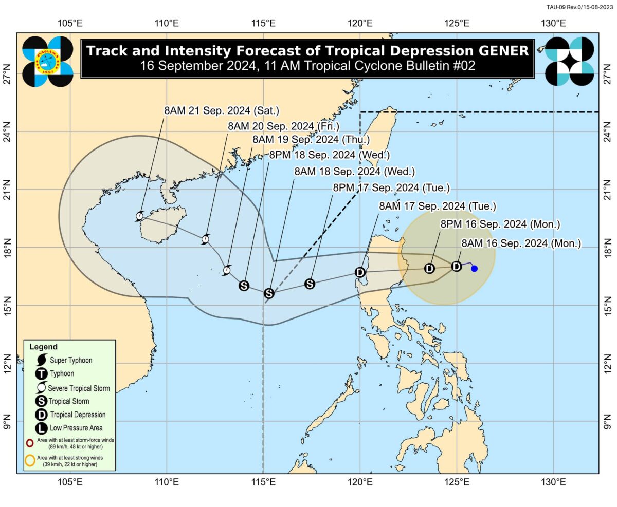
Photo from the Philippine Atmospheric, Geophysical and Astronomical Services Administration
MANILA, Philippines — More areas were placed under Signal No. 1 as Tropical Depression Gener slightly intensified while moving slowly over the Philippine Sea, according to the state weather bureau.
In its 11 a.m. bulletin, the Philippine Atmospheric, Geophysical and Astronomical Services Administration (Pagasa) reported that Gener was last spotted 325 kilometers East of Casiguran, Aurora.
READ: LPA now a tropical depression; Signal No. 1 up in northern Luzon areas
The tropical depression was carrying maximum sustained winds of 55 kilometers per hour (kph) and gusts of up to 70 kph.
Following this development, Pagasa raised Tropical Cyclone Wind Signal (TCWS) Number 1 over seven more areas:
Article continues after this advertisement- Benguet
- Ilocos Norte
- Ilocos Sur
- La Union
- Pangasinan
- Zambales
- Tarlac
Meanwhile, the following areas remain under TCWS No. 1:
Article continues after this advertisement- Cagayan, including Babuyan Islands
- Isabela
- Quirino
- Nueva Vizcaya
- Apayao
- Kalinga
- Abra
- Ifugao
- Mountain Province
- Nueva Ecija
- Aurora
- The northern portion of Quezon (General Nakar, Infanta, Real), including the Polillo Islands
Gener has also enhanced the southwest monsoon or habagat, which is expected to bring strong winds to the following areas:
- Mimaropa
- Bicol Region
- Visayas
- Zamboanga Peninsula
- Northern Mindanao
- Caraga
- Davao Region
A gale warning is likewise hoisted over the western and southern seaboards of Southern Luzon, Visayas, and Mindanao’s western, northern, and eastern seaboards.
Based on Pagasa’s cyclone update, Gener is forecast to make landfall in the vicinity of Isabela or Aurora within the next 24 hours and may likely emerge over the coastal waters of La Union or Pangasinan on the morning of Sept. 17, Tuesday.
“Gener may exit the Philippine area of Responsibility (PAR) between Tuesday late evening and Wednesday morning,” Pagasa said.
“Outside the PAR region, Gener will continue heading northwestward or west-northwestward and make landfall over southern mainland China on Friday (September 20),” it added.