Ofel continues to weaken; no more areas under Signal No. 4

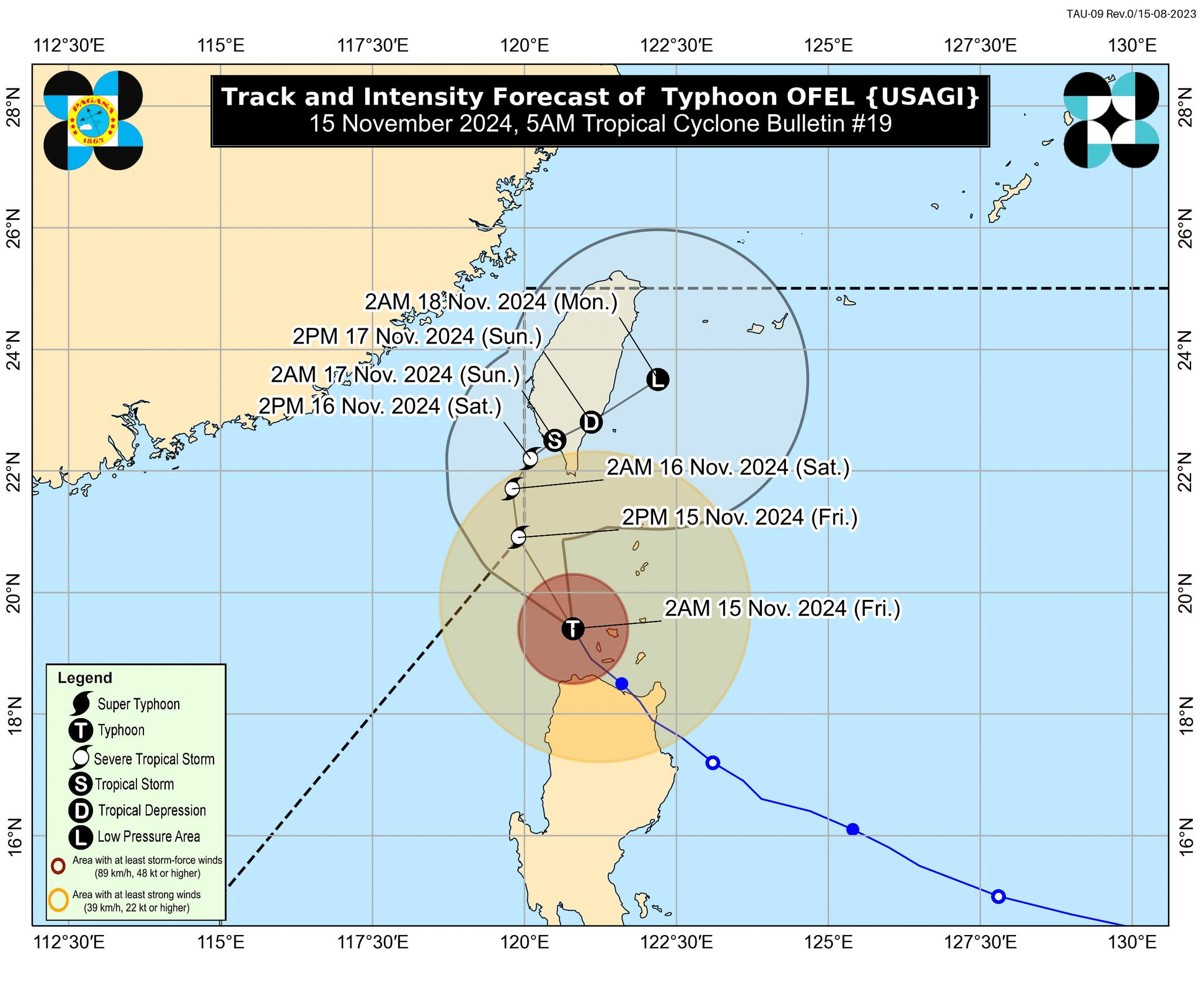
Typhoon Ofel (international name: Usagi) track and intensity forecast as of 5 a.m. on Friday, November 15, 2024. – Ofel continued to weaken early Friday morning, and no more areas were placed under Tropical Cyclone Wind Signal No. 4, according to the Philippine Atmospheric, Geophysical and Astronomical Services Administration (Pagasa). (Photo from Pagasa via Facebook)
MANILA, Philippines — Typhoon Ofel (international name: Usagi) continued to weaken early Friday morning, and no more areas were placed under Tropical Cyclone Wind Signal No. 4.
Based on the 5 a.m. cyclone bulletin of the Philippine Atmospheric, Geophysical and Astronomical Services Administration (Pagasa), Ofel was last located 100 kilometers northwest of Calayan, Cagayan, packing maximum sustained winds of 120 kilometers per hour (kph) and gustiness of up to 150 kph.

Rescuers evacuate residents in Buguey, Cagayan province, ahead of Typhoon Ofel’s landfall on November 14, 2024. (AFP photo / Buguey Municipal Disaster Risk and Reduction Management Office via Cagayan Provincial Public Information Office)
Ofel was moving north-northwestward at 20 kph, it added.
LIVE UPDATES: Typhoon Ofel and Severe Tropical Storm Pepito
“Ofel is forecast to further weaken throughout the forecast period due to the increasingly unfavorable environment from Luzon Strait up to the sea east of Taiwan, where Ofel may weaken into a remnant low,” Pagasa explained.
READ: Ofel to exit PAR on Friday after passing Babuyan Islands, Cagayan
Ofel is expected to leave the northwestern boundary of the Philippine area of responsibility (PAR) by Friday afternoon, according to the state weather agency.

However, Ofel still triggered Tropical Cyclone Wind Signals (TCWS) in some areas of Northern Luzon as of Friday morning.
Pagasa said TCWS No. 3 is up at:
- The western portion of the Babuyan Islands (Calayan Is., Dalupiri Is., Fuga Is.)
- The northern portion of Cagayan (Claveria, Santa Praxedes)
- The northernmost portion of Ilocos Norte (Pagudpud)
These areas were forecast to experience wind speeds of 89 kph to 117 kph, which pose a moderate to significant threat to life and property.
TCWS No. 2, where winds greater than 62 kph to 88 kph will occur, was raised over:
- The rest of Babuyan Island
- The northwestern portion of mainland Cagayan (Sanchez-Mira, Pamplona, Abulug, Ballesteros)
- The northern portion of Apayao (Calanasan, Luna, Santa Marcela)
- The northern portion of Ilocos Norte (Piddig, Bacarra, Adams, Dumalneg, Vintar, Bangui, Burgos, Pasuquin, Carasi)
The state weather bureau said wind speeds in these areas may cause minor to moderate impacts on life and property.
READ: Ofel lashes Cagayan as Pepito nears Luzon
Lastly, Pagasa said the following places are under TCWS No. 1:
- Batanes
- The rest of Cagayan
- The northern portion of Isabela (Quezon, Cabagan, Santa Maria, San Pablo, Maconacon, Santo Tomas, Delfin Albano, Tumauini
- The rest of Apayao
- Kalinga
- The northern and central portions of Abra (Manabo, Pidigan, Tayum, Langiden, Boliney, Sallapadan, Bucloc, La Paz, Peñarrubia, Dolores, Bangued, Bucay, Daguioman, Lacub, Tineg, Lagayan, Licuan-Baay, Malibcong, San Juan, Lagangilang, Danglas)
- The rest of Ilocos Norte
- The northern portion of Ilocos Sur (Sinait, Cabugao, San Juan, San Ildefonso, Magsingal, Santo Domingo, Bantay, San Vicente)
Areas under this wind signal will see 39 kph to 61 kph wind speeds, which may bring minimal to minor threats to life and property.
Due to the effects of Ofel, Pagasa hoisted a gale warning over the northern and eastern seaboards of Northern Luzon.