Pepito to become typhoon in 12 hrs, hit land at peak intensity

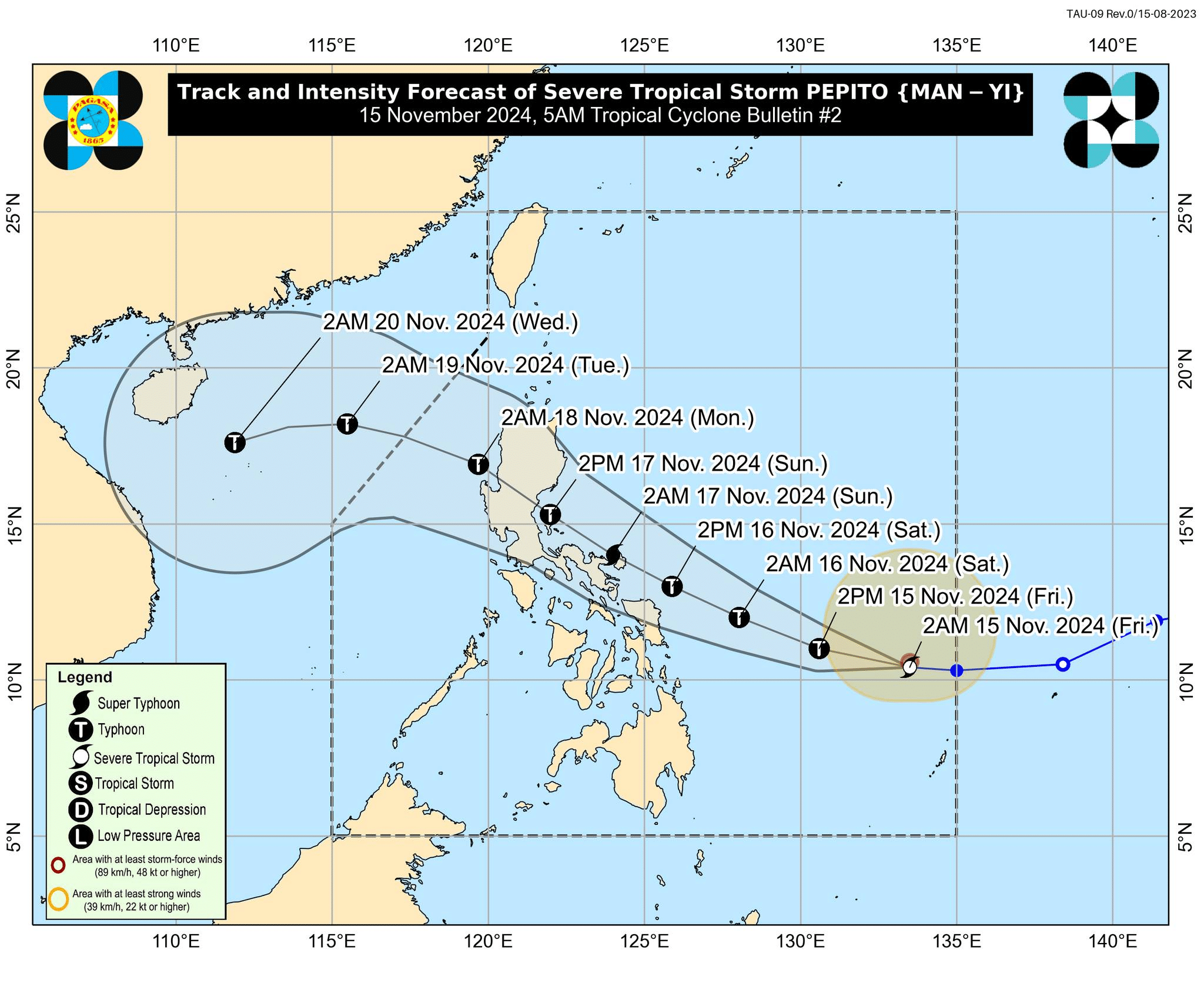
Severe Tropical Storm Pepito (international name: Man-yi) track and intensity forecast as of 5 a.m. on Friday, November 15, 2024. – Pepito further intensified and was nearing typhoon status early Friday morning, the Philippine Atmospheric, Geophysical and Astronomical Services Administration (Pagasa) said. The state weather agency also said Pepito will gain more strength to become a super typhoon by Saturday evening, November 16. It added that the weather disturbance may make landfall at peak intensity.. (Photo from Pagasa via Facebook)
MANILA, Philippines — Severe Tropical Storm Pepito (international name: Man-yi) further intensified and was nearing typhoon status early Friday morning, the Philippine Atmospheric, Geophysical and Astronomical Services Administration (Pagasa) said.
In its 5 a.m. weather bulletin, Pagasa said that Pepito “is forecast to intensify into a typhoon within the next 12 hours” and gain more strength to become a super typhoon by Saturday evening, November 16.
Pagasa also said Pepito may make landfall at peak intensity.
LIVE UPDATES: Typhoon Ofel and Severe Tropical Storm Pepito
Pepito was last located 795 kilometers east of Guiuan, Eastern Samar, moving westward at 25 kilometers per hour (kph) and carrying maximum sustained winds of 110 kph and gustiness of up to 135 kph.
Article continues after this advertisementREAD: Pepito to make landfall this weekend, may become super typhoon
Article continues after this advertisementPagasa specialist Dan Villamil said during the Friday morning weathercast that some areas may start to feel Pepito’s wind strength in 36 hours.
He also explained that Pepito’s “confidence cone” is wide and covers portions of Central Luzon, Southern Luzon, and Eastern Visayas. These areas, he noted, have a high chance of being affected by Pepito’s landfall or direct hit.
Although current data shows Pepito’s “southward shift” track, Villamil said they are not discounting the possibility that Peopito will make landfall in the eastern coasts of Central Luzon, Southern Luzon, or Eastern Visayas.
Villamil added that Pagasa may raise the highest Tropical Cyclone Wind Signal (TCWS) No. 5 for Pepito.
For now, however, Pagasa hoisted TCWS No. 1 over the following areas:
Luzon
- Catanduanes
- Eastern portion of Camarines Norte (Vinzons, Talisay, Daet, Mercedes, Basud)
- Eastern portion of Camarines Sur (Caramoan, Garchitorena, Presentacion, San Jose, Lagonoy, Tinambac, Goa, Siruma, Tigaon, Sagñay, Calabangay, Naga City, Magarao, Bombon, Pili, Ocampo, Iriga City, Buhi)
- Eastern portion of Albay (Rapu-Rapu, City of Tabaco, Malilipot, Santo Domingo, Bacacay, Legazpi City, Malinao, Manito, Tiwi)
- Eastern and southern portions of Sorsogon (Juban, City of Sorsogon, Barcelona, Bulusan, Magallanes, Gubat, Santa Magdalena, Casiguran, Bulan, Irosin, Matnog, Prieto Diaz, Castilla)
Visayas
- Northern Samar
- Northern portion of Eastern Samar (San Policarpo, Arteche, Jipapad, Maslog, Dolores, Oras, Can-Avid)
- Northeastern portion of Samar (Matuguinao, San Jose de Buan)
Areas under TCWS No. 1 may experience minimal to minor impacts from strong winds, according to Pagasa.
READ: LIST: Storm surge warning in parts of Luzon, Visayas due to Pepito
Pepito “will continue to bring violent conditions over the coastal areas of Southern Luzon and Central Luzon until Sunday (17 November) prior to a second landfall over the eastern section of Central or Southern Luzon,” the state weather agency noted.
Due to this, the state weather agency hoisted a storm surge warning for 48 hours over the low-lying or coastal areas of the following:
- Camarines Sur
- Catanduanes
- Albay
- Sorsogon
- Northern Samar
- Eastern Samar
- Samar
However, no gale warning was raised due to Pepito, according to Pagasa.
On the other hand, Typhoon Ofel (international name: Usagi) – though weakened – prompted gale alerts in northern and eastern seaboards of Northern Luzon.