Ofel to exit PAR on Friday after passing Babuyan Islands, Cagayan

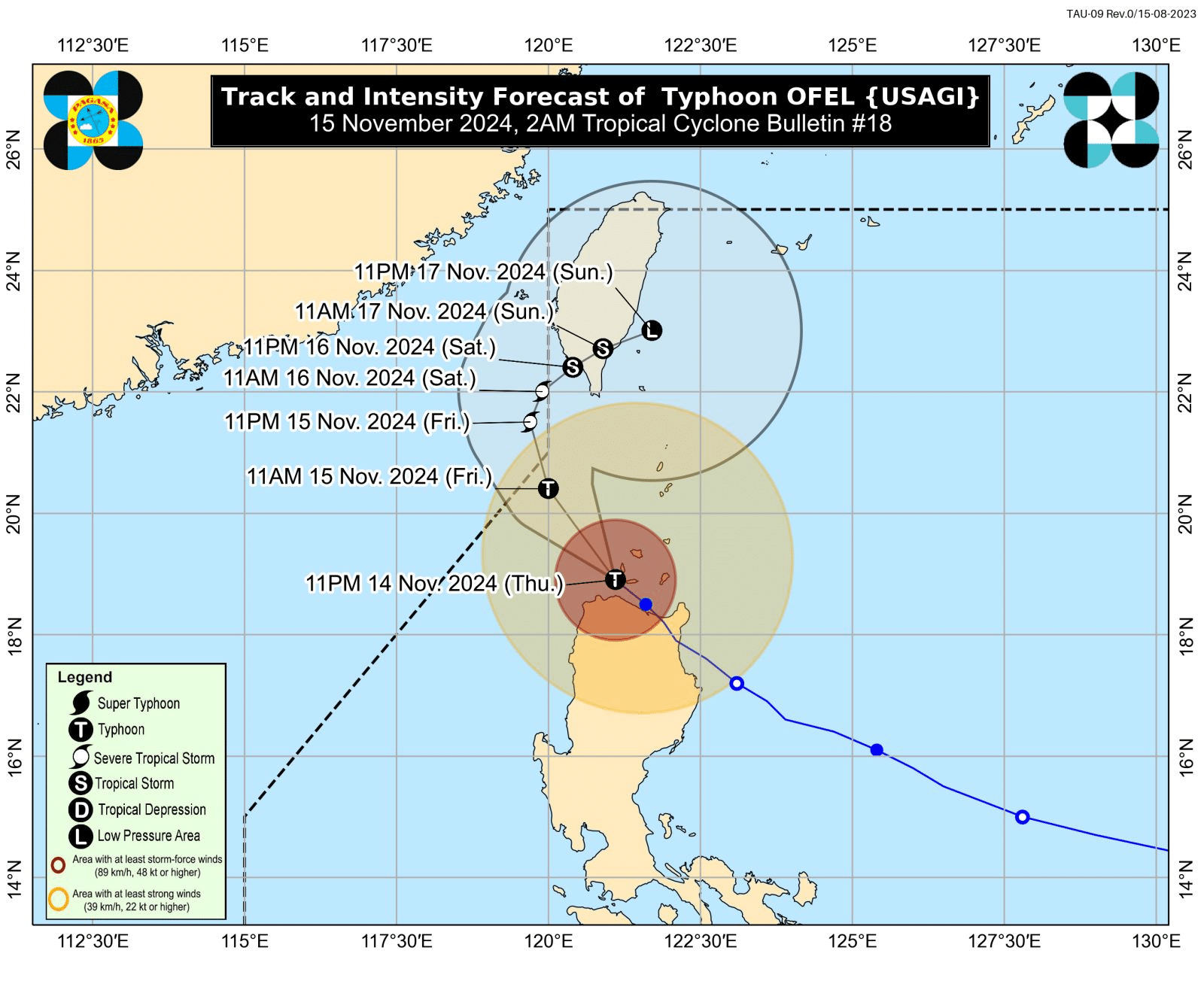
Track and intensity forecast of Typhoon Ofel (international name: Usagi) as of 2 a.m. on Friday, November 15, 2024. (Photo by Pagasa)
MANILA, Philippines — Typhoon Ofel (international name: Usagi) passed closely between the Babuyan Islands and the northern portion of mainland Cagayan and may exit the northwestern boundary of the Philippine area of responsibility (PAR) on Friday afternoon, the state weather bureau said.
In its 2 a.m. weather bulletin, the Philippine Atmospheric, Geophysical and Astronomical Services Administration (Pagasa) said that Ofel will move generally northward outside PAR until Saturday morning over the west of Batanes.
The state weather bureau added that Ofel “may re-enter PAR region as it turns generally northwestward towards Taiwan and will remain inside PAR until the rest of the weekend.”
READ: Ofel further weakens, to re-enter PAR on Saturday
Ofel was last located over the coastal waters of Calayan, Cagayan, moving northwestward at 25 kilometers per hour (kph) and carrying a maximum wind speed of 130 kph and gustiness of up to 180 kph.
It is also expected to weaken “due to the increasingly unfavorable environment over the Luzon Strait and over the sea east of Taiwan.”
Pagasa also raised the Tropical Cyclone Wind Signals (TCWS) over the following areas:
- TCWS No. 4 (118–184 kph wind speed)
Significant to severe threat to life and property
- Luzon:
- Western portion of Babuyan Islands: Calayan Is., Dalupiri Is., Fuga Is.
- Northern portion of Cagayan: Ballesteros, Abulug, Pamplona, Sanchez-Mira, Claveria, Santa Praxedes
- Northernmost portion of Ilocos Norte: Pagudpud
- Luzon:
- TCWS No. 3 (89–117 kph wind speed)
Moderate to significant threat to life and property
- Luzon:
- Central and southeastern portions of mainland Cagayan: Lasam, Alcala, Amulung, Iguig, Santo Niño, Iguig, Rizal, Santa Teresita, Santa Ana, Lal-Lo, Buguey, Allacapan, Camalaniugan, Baggao, Aparri
- Northern and central portions of Apayao: Flora, Pudtol, Kabugao, Calanasan, Luna, Santa Marcela
- Northern portion of Ilocos Norte: Adams, Dumalneg, Bangui, Pasuquin, Burgos, Vintar, Carasi
- Luzon:
- TCWS No. 2 (greater than 62–88 kph wind speed)
Minor to moderate impacts to life and property
- Luzon:
- Batanes
- Rest of Cagayan
- Rest of Apayao
- Northern portion of Kalinga: Pinukpuk, Rizal, City of Tabuk, Balbalan
- Northern portion of Abra: Tineg, Lacub, Malibcong, Lagayan, San Juan, Lagangilang, Licuan-Baay
- Rest of Ilocos Norte
- Luzon:
- TCWS No. 1 (39–61 kph wind speed)
Minimal to minor threat to life and property
- Luzon:
- Northern portion of Isabela: Santo Tomas, Alicia, San Mateo, Aurora, Santa Maria, Quezon, San Mariano, Ramon, Naguilian, Dinapigue, Roxas, San Guillermo, Luna, Delfin Albano, City of Cauayan, Echague, San Pablo, Ilagan City, Angadanan, Benito Soliven, City of Santiago, Tumauini, Cabagan, Reina Mercedes, San Manuel, Palanan, Cabatuan, Quirino, Divilacan, Gamu, San Isidro, Mallig, Cordon, Maconacon, Burgos
- Rest of Abra
- Rest of Kalinga
- Northern and eastern portions of Mountain Province: Besao, Sagada, Sadanga, Bontoc, Natonin, Barlig, Paracelis
- Northern portion of Ifugao: Aguinaldo, Alfonso Lista
- Northern and central portions of Ilocos Sur: Sinait, Cabugao, San Juan, San Ildefonso, Magsingal, Santo Domingo, Bantay, San Vicente, City of Vigan, Caoayan, Santa Catalina, Santa, Nagbukel, Narvacan, Gregorio del Pilar, San Esteban, Banayoyo, Burgos, City of Candon, Santa Lucia, Santiago, Lidlidda, Sigay, Galimuyod, Quirino, San Emilio, Santa Maria, Salcedo
- Luzon:
A gale warning was also hoisted over the northern and eastern seaboards of Northern Luzon.
The following coastal waters may experience moderate up to very rough or high seas:
- Gale Warning (very rough or high seas):
- Up to 8.0 meters (m):
- Seaboards of Batanes and Babuyan Islands
- Up to 4.5 meters (m):
- Northern seaboards of Ilocos Norte
- Northern Cagayan
- Up to 8.0 meters (m):
- Rough seas (up to 4.0 meters):
- Eastern seaboard of Cagayan
- Seaboard of Isabela
- Moderate seas (up to 2.5 meters):
- Western seaboard of Ilocos Norte
- Northern and eastern seaboards of Catanduanes and Northern Samar
- Eastern seaboards of Albay, Sorsogon, and Eastern Samar
- Dinagat Islands
- Surigao del Norte (including Siargao and Bucas Grande Islands)
- Surigao del Sur
- Davao Oriental
- Up to 2.0 meters:
- Remaining seaboard of Aurora
- Eastern seaboard of Quezon (including Polillo Islands)
- Seaboard of Camarines Norte
- Northern and eastern seaboards of Camarines Sur
- Remaining seaboard of Catanduanes
READ: Pepito to make landfall this weekend, may become super typhoon