Typhoon Nika now stronger, prompts Signal No. 4 in 7 areas

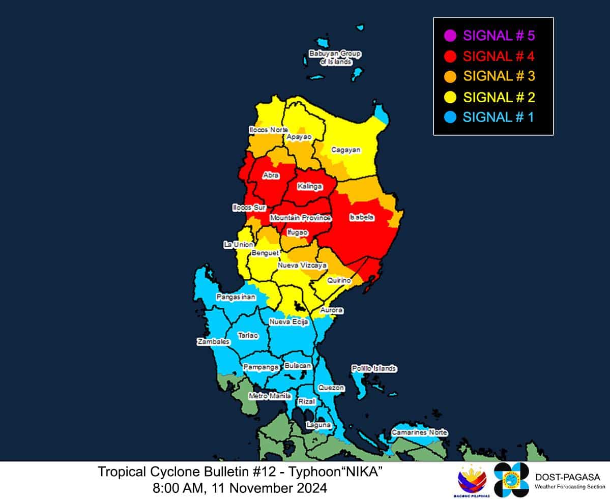
Typhoon Nika (international name: Toraji) further intensifies as it approaches the boundary of Isabela and Aurora provinces on Monday morning (November 11, 2024). Now, seven Northern Luzon areas are placed under Tropical Cyclone Wind Signal (TCWS) No. 4. Photo from Pagasa
MANILA, Philippines — Typhoon Nika (international name: Toraji) further intensified as it approached the boundary of Isabela and Aurora provinces. Now, seven Northern Luzon areas are placed under Tropical Cyclone Wind Signal (TCWS) No. 4.
The Philippine Atmospheric, Geophysical and Astronomical Services Administration (Pagasa) said in its 8 a.m. typhoon bulletin that Nika was last spotted over the coastal waters of Dilasag, Aurora, packing maximum sustained winds of 130 kilometers per hour (kph) and gusts of up to 180 kph.
Nika was moving west-northwestward at 15 kph.
“On the track forecast, Nika may make landfall over Isabela or northern Aurora” this Monday morning, according to Pagasa.
Article continues after this advertisementREAD: LIVE UPDATES: Typhoon Nika
Article continues after this advertisementPagasa, however, later announced that Nika already made landfall near Dilasag, Aurora at 8:10 a.m.
The state weather agency’s newest advisory indicated that TCWS No. 4 expanded from the earlier six areas to seven, as follows:
- Northernmost portion of Aurora (Dilasag, Casiguran)
- Central and southern portions of Isabela (Dinapigue, San Mariano, San Guillermo, Jones, Echague, Ramon, San Isidro, City of Santiago, Cordon, Roxas, Burgos, Reina Mercedes, Naguilian, Benito Soliven, Gamu, San Manuel, Aurora, San Mateo, Cabatuan, Alicia, Luna, City of Cauayan, Angadanan, Quezon, Mallig, Quirino, Ilagan City, Delfin Albano, San Agustin)
- Kalinga
- Mountain Province
- Northern portion of Ifugao (Aguinaldo, Mayoyao, Alfonso Lista, Banaue, Hungduan, Hingyon, Lagawe)
- Central and southern portion of Abra (Manabo, Pidigan, San Juan, Tayum, Langiden, Luba, Boliney, Sallapadan, Bucloc, Lagangilang, Tubo, Danglas, Villaviciosa, La Paz, Licuan-Baay, Pilar, Malibcong, Pe, San Isidro, Daguioman, San Quintin, Dolores, Lagayan, Bangued, Bucay, Lacub)
- Northern and central portions of Ilocos Sur (Cabugao, Sinait, San Juan, San Emilio, Lidlidda, Banayoyo, Santiago, San Esteban, Burgos, Santa Maria, Magsingal, San Vicente, Santa Catalina, Nagbukel, San Ildefonso, City of Vigan, Caoayan, Santa, Bantay, Santo Domingo, Narvacan, Quirino, Cervantes, Sigay, Salcedo, Santa Lucia, City of Candon, Galimuyod, Gregorio del Pilar, Santa Cruz)
These places may experience typhoon-force winds exceeding 118 kph up to 184 kph within 12 hours, which may cause significant to severe impacts.
Pagasa likewise hoisted TCWS No. 3 over the following areas:
- Central portion of Aurora (Dinalungan)
- Northern portion of Quirino (Diffun, Cabarroguis, Aglipay, Saguday, Maddela)
- Northeastern portion of Nueva Vizcaya (Diadi, Bagabag, Quezon, Solano, Villaverde, Kasibu, Ambaguio, Bayombong)
- Rest of Isabela
- Southwestern portion of Cagayan (Enrile, Solana, Tuao, Tuguegarao City, Rizal, Piat)
- Southern portion of Apayao (Conner, Kabugao)
- Rest of Abra
- Rest of Ifugao
- Northern portion of Benguet (Buguias, Mankayan, Bakun)
- Southern portion of Ilocos Norte (Laoag City, Sarrat, San Nicolas, Piddig, Marcos, Nueva Era, Dingras, Bacarra, Solsona, Paoay, Currimao, Pinili, Badoc, City of Batac, Banna)
- Rest of Ilocos Sur
Storm-force winds with speeds between 89 kph and 117 kph may be felt in these areas within 18 hours.
READ: Nika now a severe tropical storm, may become a typhoon
Also, Pagasa declared TCWS No. 2, which entails gale-force winds of 62 kph up to 88 kph within 24 hours, in the following places:
- Northwestern and eastern portions of Cagayan (Iguig, Peñablanca, Baggao, Alcala, Amulung, Santo Niño, Gattaran, Lasam, Santa Praxedes, Claveria, Sanchez-Mira, Pamplona, Abulug, Allacapan, Ballesteros, Lal-Lo, Aparri, Camalaniugan, Buguey, Santa Teresita, Gonzaga),
- Rest of Nueva Vizcaya
- Rest of Quirino
- Rest of Apayao
- Rest of Benguet
- Rest of Ilocos Norte
- La Union
- Northeastern portion of Pangasinan (San Nicolas, Natividad, San Quintin, Sison, San Manuel, Umingan, Tayug)
- Central portion of Aurora (Dipaculao, Maria Aurora, Baler)
- Northern portion of Nueva Ecija (Carranglan, Pantabangan, Lupao, San Jose City)
As for areas under TCWS No. 1, Pagasa listed the following:
- Babuyan Islands
- Rest of mainland Cagayan
- Rest of Pangasinan
- Rest of Aurora
- Rest of Nueva Ecija
- Bulacan
- Pampanga
- Tarlac
- Northern and central portions of Zambales (Santa Cruz, Candelaria, Masinloc, Palauig, Iba, Botolan, Cabangan, San Marcelino, San Felipe, San Narciso)
- Metro Manila
- Rizal
- Eastern portion of Laguna (Santa Maria, Mabitac, Pakil, Pangil, Famy, Siniloan, Paete, Kalayaan, Cavinti, Lumban, Luisiana, Santa Cruz, Magdalena, Pagsanjan, Pila)
- Northern and eastern portions of Quezon (Infanta, Quezon, Alabat, Sampaloc, Mauban, Perez, Real, General Nakar, Calauag) including Pollilo Islands
- Northwestern portion of Camarines Norte (Capalonga, Santa Elena, Vinzons, Labo, Paracale, San Vicente, Talisay, Daet, Jose Panganiban)
These areas are anticipated to experience strong winds of 39 kph up to 61 kph in 36 hours,
Pagasa said Nika’s effects include intense to torrential rains of greater than 200 millimeters (mm) over the provinces of Aurora, Isabela, Cagayan, Quirino, Nueva Vizcaya, Ifugao, Mountain Province, Kalinga, and Apayao.
Heavy to intense (100-200 mm) rains may also be expected over the provinces of Abra, Benguet, Ilocos Norte, Ilocos Sur, and La Union.
Pagasa added that Nika would dump moderate to heavy rains of 50 to 100 mm over Camarines Norte, Camarines Sur, Quezon, Nueva Ecija, Tarlac, and Pangasinan provinces.