Nika intensifies into a typhoon; 6 areas in Northern Luzon under Signal No. 4

MANILA, Philippines — Tropical Storm Nika (international name: Toraji) intensified into a typhoon early Monday morning, the Philippine Atmospheric, Geophysical, and Astronomical Services Administration (Pagasa) reported.
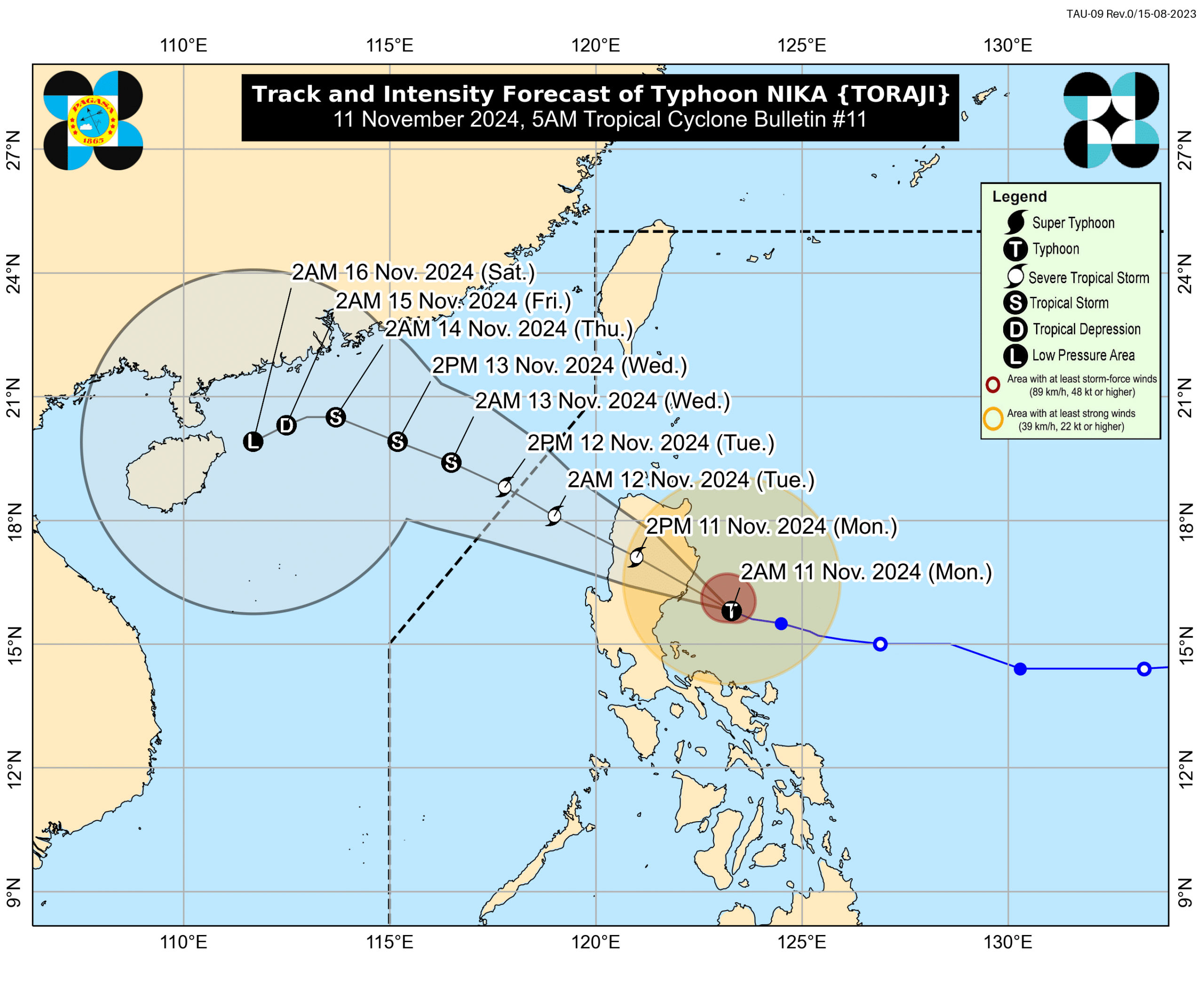
In a 5 a.m. bulletin, Pagasa said Nika was last spotted some 100 kilometers (km) east southeast of Casiguran, Aurora.
It now packs maximum sustained winds of 120 kilometers per hour (kph) near its center, with up to 150 kph gusts.
Nika is moving west-northwestward at 20 kph, the state weather bureau noted.
Due to these developments, Pagasa hoisted Tropical Cyclone Wind Signal (TCWS) No. 4 in six Luzon areas:
- Northernmost portion of Aurora (Dilasag, Casiguran)
- Central and southern portions of Isabela (Dinapigue, San Mariano, San Guillermo, Jones, Echague, Ramon, San Isidro, City of Santiago, Cordon, Roxas, Burgos, Reina Mercedes, Naguilian, Benito Soliven, Gamu, San Manuel, Aurora, San Mateo, Cabatuan, Alicia, Luna, City of Cauayan, Angadanan, Quezon, Mallig, Quirino, Ilagan City, Delfin Albano, San Agustin)
- Southeastern portion of Abra (Tubo, Boliney, Daguioman, Bucloc, Malibcong)
- Central and eastern portions of Mountain Province (Sadanga, Bontoc, Barlig, Natonin, Paracelis) Eastern portion of Ifugao (Aguinaldo, Mayoyao, Alfonso Lista)
- Western and southern portions of Kalinga (Tanudan, Tinglayan, Pasil, Lubuagan, Balbalan, City of Tabuk)
Areas under TCWS No. 4 may expect winds of greater than 118 kph up to 184 kph in the next 12 hours.
Meanwhile, the following areas were placed under TCWS No. 3, where wind speeds of greater than 89 kph up to 117 kph may be expected in at least 18 hours:
- Northern portion of Aurora (Dinalungan)
- Northeastern portion of Nueva Vizcaya (Diadi, Bagabag, Quezon, Solano, Villaverde, Kasibu, Ambaguio, Bayombong)
- Northern portion of Quirino (Diffun, Cabarroguis, Aglipay, Saguday, Maddela)
- The rest of Isabela
- Southwestern portion of Cagayan (Enrile, Solana, Tuao, Tuguegarao City, Rizal, Piat)
- The rest of Abra
- The southern portion of Apayao (Conner, Kabugao)
- The rest of Kalinga
- The rest of Mountain Province
- The rest of Ifugao
- Northern portion of Benguet (Buguias, Mankayan, Bakun)
- Southern portion of Ilocos Norte (Laoag City, Sarrat, San Nicolas, Piddig, Marcos, Nueva Era, Dingras, Bacarra, Solsona, Paoay, Currimao, Pinili, Badoc, City of Batac, Banna)
- Ilocos Sur
Pagasa also raised TCWS No. 2 in the following areas:
- Central portion of Aurora (Dipaculao, Maria Aurora, Baler)
- The rest of Nueva Vizcaya
- The rest of Quirino
- Northwestern and eastern portions of Cagayan (Iguig, Peñablanca, Baggao, Alcala, Amulung, Santo Niño, Gattaran, Lasam, Santa Praxedes, Claveria, Sanchez-Mira, Pamplona, Abulug, Allacapan, Ballesteros, Lal-Lo, Aparri, Camalaniugan, Buguey, Santa Teresita, Gonzaga)
- The rest of Apayao
- The rest of Benguet
- The rest of Ilocos Norte, La Union
- Northeastern portion of Pangasinan (San Nicolas, Natividad, San Quintin, Sison, San Manuel, Umingan, Tayug)
- Northern portion of Nueva Ecija (Carranglan, Pantabangan, Lupao, San Jose City)
Winds stronger than 62 kph and up to 88 kph may affect areas under TCWS No. 2 within the next 24 hours.
The following areas were also placed by Pagasa under TCWS No. 1:
- The rest of Aurora
- The rest of Cagayan, including the Babuyan Islands
- The rest of Pangasinan
- The rest of Nueva Ecija
- Bulacan
- Pampanga
- Tarlac
- Northern and central portions of Zambales (Santa Cruz, Candelaria, Masinloc, Palauig, Iba, Botolan, Cabangan, San Marcelino, San Felipe, San Narciso)
- Metro Manila
- Rizal
- Eastern portion of Laguna (Santa Maria, Mabitac, Pakil, Pangil, Famy, Siniloan, Paete, Kalayaan, Cavinti, Lumban, Luisiana, Santa Cruz, Magdalena, Pagsanjan, Majayjay, Liliw, Nagcarlan, Pila, Victoria)
- Northern and eastern portions of Quezon (Calauag, Infanta, Quezon, Alabat, Sampaloc, Mauban, Perez, Real, General Nakar, Tagkawayan, Guinayangan) including Pollilo Islands
- Camarines Norte
- Northeastern portion of Camarines Sur (Siruma, Tinambac, Garchitorena, Lagonoy)
Areas under TCWS may experience intermittent rains and winds ranging from 39 to 61 kph within the next 36 hours.
Based on the state weather bureau’s latest forecast track, Nika is forecast to move generally west-northwestward until Thursday, before turning generally southwestward on Friday onwards.
According to Pagasa, the typhoon may make landfall over Isabela or northern Aurora on Monday morning, with further intensification still possible.
“Nika will continue to move west-northwestward over the West Philippine Sea and exit the Philippine Area of Responsibility by tomorrow (12 November) morning or afternoon,” state meteorologists added.
Pagasa hoisted a gale warning over the eastern seaboard of Luzon and the northern and western seaboard of Northern Luzon.
READ: Tropical Storm Nika may cause storm surge in 13 Luzon provinces