Pagasa: Egay maintains strength en route to southeastern Luzon
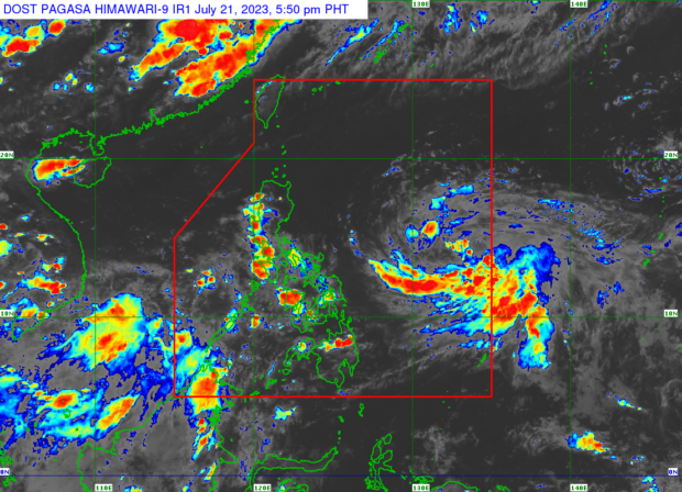
MANILA, Philippines — Tropical Depression Egay maintained its strength while approaching the southeastern part of Luzon, the Philippine Atmospheric, Geophysical and Astronomical Services Administration (Pagasa) reported Friday afternoon.
The state weather bureau said Pagasa said Egay still packs maximum sustained winds of 55 kilometers per hour (kph) near the center, and gustiness of up to 70 kph.
It was tracked Friday afternoon some 835 kms. east of southeastern Luzon, and is moving west-northwest at 20 kph.
Storm, super typhoon possible
No Tropical Cyclone Wind Signals have been raised, so far, but Pagasa predicts that Egay to intensify into a tropical storm while over the country’s waters by Friday night or Saturday morning.
Article continues after this advertisementBy Saturday afternoon, Egay is expected to be 730 kilometers east of Daet, Camarines Norte.
Article continues after this advertisementIt is forecast to be some 705 kilometers east of Infanta, Quezon by Sunday afternoon and may further intensify into a super typhoon by Monday or Tuesday with a maximum sustained wind speed of 185 kph.
“Egay is forecast to intensify in the next 12 hours into a tropical storm. Throughout its duration in the PAR region, it may continue to steadily intensify and reach super typhoon category by late Monday or early Tuesday as it moves over the Philippine Sea east of Luzon,” Pagasa said.
“Considering these developments, the public and disaster risk reduction and management offices concerned are advised to take all necessary measures to protect life and property. Persons living in areas identified to be highly or very highly susceptible to these hazards are advised to follow evacuation and other instructions from local officials,” Pagasa added.
While there is a slim chance that Egay will make landfall, Pagasa enjoined the public to continue monitoring weather updates and coordinate with local authorities regarding possible evacuation.
‘Habagat” rain alert
The state weather bureau also noted that Egay would intensify the southwest monsoon or “habagat” and trigger rainfall bringing in several parts of the country, particularly Luzon.
This means that rains are highly likely as President Ferdinand Marcos Jr. delivers his second State of the Nation Address (Sona) on Monday.
“In areas that will not be directly affected by Egay, monsoon rains from the enhanced southwest monsoon are possible over the western section of Minaropa (Mindoro, Marinduque, Romblon, Palawan) and Visayas on Sunday. On Monday and Tuesday, monsoon rains are likely over the western section of Southern Luzon and Western Visayas,” Pagasa said.
“Under these conditions, flooding and rain-induced landslides are possible, especially in areas that are highly or very highly susceptible to these hazard as identified in hazard maps and in localities that experienced considerable amounts of rainfall for the past several days,” it added.