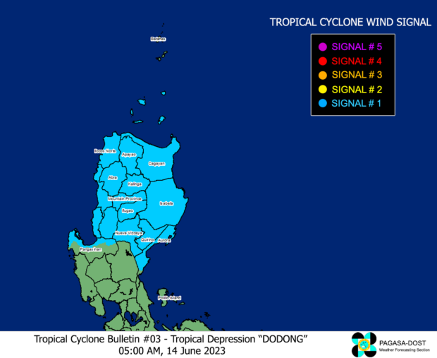
Photo from Pagasa
MANILA, Philippines — The low pressure area in northern Luzon strengthened early Friday morning and is now known as Tropical Depression Dodong, the state weather bureau said.
Consequently, the Philippine Atmospheric, Geophysical and Astronomical Services Administration (Pagasa) raised Tropical Cyclone Wind Signal (TCWS) No. 1 over 16 areas where strong winds between 39 and 61 kilometers per hour (kph) may be expected – posing “minimal to minor threat to life and property.”
According to Pagasa’s latest weather bulletin, Dodong already made landfall in Dinapigue, Isabela, as of 5:00 a.m. Friday and presently in the vicinity of San Mariano, Isabela, packing maximum sustained winds of 45 kph and gustiness of 75 kph.
READ: #WalangPasok: Class suspensions for July 14 due to Tropical Depression Dodong
READ: LIST: July 14 canceled flights due to Tropical Depression Dodong
The state weather bureau warned that flooding and rain-induced landslides are likely to happen in the following areas under Signal No. 1:
- Cagayan
- Isabela
- Quirino
- Nueva Vizcaya
- Apayao
- Kalinga
- Abra
- Mountain Province
- Ifugao
- Benguet
- Ilocos Norte
- Ilocos Sur
- La Union
- Northern portion of Pangasinan (San Nicolas, San Manuel, Sison, San Fabian, Pozorrubio, Bolinao, Bani, City of Alaminos, Sual, Labrador, Lingayen, Agno, Binmaley, Dagupan City, San Jacinto, Mangaldan, Anda),
- Northern and central portions of Aurora (Maria Aurora, San Luis, Baler, Dipaculao, Dinalungan, Casiguran, Dilasag)
Meanwhile, Pagasa said Metro Manila, Calabarzon, Mimaropa and the rest of Central Luzon will experience monsoon rains due to the combined effects of the southwest monsoon and Dodong.
READ: Pagasa says Tropical Depression Dodong to leave PAR over the weekend
The Bicol Region, Visayas, and Zamboanga Peninsula may also anticipate rain due to the monsoon, it added.
RELATED STORIES
Potential LPA spotted east of Luzon – Pagasa
LPA, habagat bring rain to Metro Manila, rest of PH – Pagasa
LPA, southwest monsoon to bring rains to most parts of PH – Pagasa