Pagasa says Tropical Depression Dodong to leave PAR over the weekend
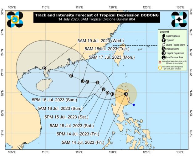
MANILA, Philippines — Tropical Depression Dodong is forecast to exit the Philippine area of responsibility (PAR) this weekend, the Philippine Atmospheric, Geophysical and Astronomical Services Administration (Pagasa) said.
According to its 8 a.m. meteorological report Friday, Dodong is expected to move west or west-northwest of northern Luzon and traverse waters west of the Ilocos Region.
READ: #WalangPasok: Class suspensions for July 14 due to Tropical Depression Dodong
“Afterwards, Dodong will move generally northwestward over the West Philippine Sea until it exits the PAR tomorrow or on Sunday,” the state weather service said.
Dodong’s center was near Lasam, Cagayan, with maximum sustained winds of 45 kph and gustiness up to 75 kph.
Article continues after this advertisementREAD: LIST: July 14 canceled flights due to Tropical Depression Dodong
Article continues after this advertisementPagasa reduced the number of areas under Tropical Cyclone Wind Signal No.1 from 16 to 12.
These areas are Cagayan, Isabela, Apayao, Kalinga, Abra, Mountain Province, Ifugao, Benguet, Ilocos Norte, Ilocos Sur, La Union, and the northern portion of Pangasinan.
READ: LPA is now Tropical Depression Dodong; 16 areas under Signal No. 1 – Pagasa
Pagasa said areas under Signal No. 1 may experience 39 to 61 kph winds for at least 36 hours or intermittent rain during Dodong’s onslaught.
RELATED STORIES
Potential LPA spotted east of Luzon – Pagasa
LPA, habagat bring rain to Metro Manila, rest of PH – Pagasa
LPA, southwest monsoon to bring rains to most parts of PH – Pagasa
