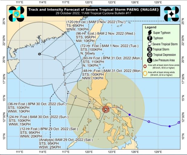
MANILA, Philippines – Severe Tropical Storm Paeng (international name: Nalgae) is forecast to make another landfall in the vicinity of the southeastern portion of Batangas before barreling through Cavite, Metro Manila and the Bataan Peninsula on Saturday, said state meteorologists.
Paeng made landfall early Saturday morning in Virac, Catanduanes followed by another one in Caramoan Camarines Sur, Buenavista in Quezon, and Santa Cruz in Marinduque, according to the Philippine Atmospheric, Geophysical and Astronomical Services Administration.
In its 11:00 a.m. update, Paeng was spotted west- southwest at 25 kilometers per hour (kph) with maximum sustained winds of 95 kph. and gustiness of up to 130 kph.
Paeng is forecast to exit the Philippine area of responsibility by Monday, added Pagasa.
Heavy to intense and at times torrential rain is expected in the Metro Manila, Calabarzon (Cavite, Laguna, Batangas, Rizal, Quezon), Bicol region, Marinduque, Romblon, the Mindoro provinces, and the northern portion of Palawan including Calamian and Cuyo Islands, said Pagasa.
Cagayan Valley, the Cordillera Administrative Region, Western Visayas, and Central Luzon will experience moderate to heavy and at times intense rains due to Paeng, Pagasa added.
The rest of the country can expect lighter rainfall.
Rough seas and storm surge alerts!
A gale warning is still in effect over the seaboards of Luzon, Visayas and the eastern seaboard of Mindanao, said Pagasa.
Sailors are urged not to venture out to sea.
A storm surge warning is also active in the coasts of western Pangasinan, Zambales, Bataan, southern Aurora, Quezon including Polillo Islands, Bulacan, Metro Manila, Cavite, Batangas, Marinduque, Camarines Norte, Camarines Sur, and Albay.
Signal No. 3 is up over the following areas / provinces:
- Marinduque
- Northern and central portions of Quezon (Pitogo, San Andres, Buenavista, Lucena City, San Francisco, Pagbilao, Infanta, Tiaong, Lopez, Catanauan, Mulanay, Unisan, General Luna, Plaridel, Quezon, San Antonio, Alabat, Candelaria, Lucban, Sampaloc, Padre Burgos, Sariaya, City of Tayabas, Macalelon, Mauban, Dolores, General Nakar, Perez, Agdangan, Gumaca, Atimonan, Real, San Narciso, Guinayangan, Calauag) including Pollilo Islands
- Laguna
- Batangas
- Cavite
- Metro Manila
- Rizal
- Bataan
- Southern portion of Zambales (Olongapo City, Subic, Castillejos, San Antonio)
- Lubang Islands
Signal No. 2 is up over the following areas / provinces:
- Northwestern portion of Sorsogon (Pilar, Donsol)
- Western portion of Masbate (Aroroy, Baleno, Mandaon) including Burias Island
- Camarines Sur
- Camarines Norte
- Oriental Mindoro
- Occidental Mindoro
- Rest of Quezon
- Romblon
- Nueva Ecija
- Pangasinan
- Albay
- Southern portion of Aurora (San Luis, Baler, Dingalan, Maria Aurora)
- Bulacan
- Pampanga
- Tarlac
- Rest of Zambales
- Northwestern portion of Antique (Libertad, Pandan, Caluya Islands)
- Western portion of Aklan (Buruanga, Malay, Nabas, Ibajay, Tangalan, Makato, Numancia, Lezo)
Signal No. 1 is up over the following areas / provinces:
- Isabela
- Nueva Vizcaya
- Quirino
- Abra
- Kalinga
- Ifugao
- Mountain Province
- Benguet
- Ilocos Sur
- La Union
- Rest of Aurora
- Catanduanes
- Rest of Sorsogon
- Rest of Masbate including Ticao Island
- Northern portion of Palawan (El Nido, Taytay, Dumaran, Araceli, Roxas, San Vicente) including Calamian and Cuyo Islands
- Northern Samar
- Samar
- Eastern Samar
- Biliran
- Leyte
- Southern Leyte
- Cebu including Bantayan and Camotes Islands
- Bohol
- Negros Occidental
- Negros Oriental
- Guimaras
- Rest of Aklan
- Rest of Antique
- Capiz
- Iloilo
RELATED STORIES:
LIVE UPDATES: Tropical Storm Paeng
Pagasa: Signal No. 3 in Metro Manila, brace for stormy weather as Paeng whips Luzon
