Pagasa: Signal No. 3 in Metro Manila, brace for stormy weather as Paeng whips Luzon

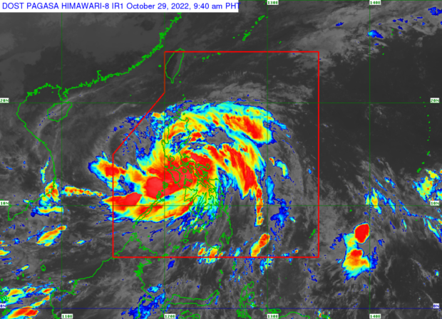
MANILA, Philippines – Tropical Cyclone Wind Signal (TCWS) Number 3 is now up over Metro Manila, along woth several other areas as Severe Tropical Storm Paeng (international name: Nalgae) barrels across the country on Saturday, the state weather bureau reported.
In its 8:00 a.m. update, the Philippine Atmospheric, Geophysical and Astronomical Services Administration (Pagasa). said Paeng was spotted over the coastal waters of Catanauan, Quezon, packing maximum sustained winds of 95 kilometers per hour (kph) near the center and gustiness of up to 160 kph.
Strong winds, heavy rain, storm surge warnings
“Winds of at most storm-force strength may occur within any of the areas where Wind Signal No. 3 is hoisted, while winds reaching gale-force strength are possible within any of the areas where Wind Signal No. 2 is in effect. Areas under Wind Signal No.1 may experience strong winds (strong breeze to near gale strength) throughout the passage of the tropical cyclone,” Pagasa said in its advisory.
Paeng is forecast to bring heavy to intense with at times torrential rains in Metro Manila, Calabarzon (Cavite, Laguna, Batangas, Rizal, Quezon) Marinduque, Romblon, the Mindoro provinces, and the northern portion of Palawan including Calamian and Cuyo Islands, said Pagasa.
Pagasa has also issued a storm surge warning in coastal areas in Paeng’s path.
*Signal No. 3 is up over the following provinces / areas
- Metro Manila
- Camarines Norte
- Western portion of Camarines Sur (Del Gallego, Ragay, Lupi, Sipocot, Cabusao, Pasacao, Libmanan, Pamplona)
- Marinduque
- Quezon including Pollilo Islands
- Laguna
- Batangas
- Cavite
- Rizal
*Signal No. 2 is up over the following provinces / areas
- Catanduanes
- Albay
- Western portion of Sorsogon (Pilar, Castilla, Donsol)
- Western portion of Masbate (Aroroy, Baleno, Mandaon) including Burias Island
- Southern portion of Aurora (San Luis, Baler, Dingalan, Maria Aurora)
- Bulacan
- Pampanga
- Bataan
- Tarlac
- Zambales
- Nueva Ecija
- Pangasinan
- Rest of Camarines Sur
- Romblon
- Oriental Mindoro
- Occidental Mindoro including Lubang Islands
* Signal No. 1 is up over the following provinces / areas
- Isabela
- Nueva Vizcaya
- Quirino
- Kalinga
- Ifugao
- Mountain Province
- Benguet
- Ilocos Sur
- La Union
- rest of Aurora
- rest of Sorsogon
- rest of Masbate including Ticao Island
- Northern portion of Palawan (El Nido, Taytay, Dumaran, Araceli, Roxas, San Vicente) including Calamian and Cuyo Islands
- Northern Samar
- Samar
- Eastern Samar
- Biliran
- Leyte
- Southern Leyte
- Cebu including Bantayan and Camotes Islands
- Bohol
- Negros Occidental
- Negros Oriental
- Guimaras
- Aklan
- Antique
- Capiz
- Iloilo
RELATED STORIES:
Article continues after this advertisementPaeng makes landfall in Camarines Sur
Paeng now a Severe Tropical Storm; Signal No. 3 up in several Bicol towns
gsg
Responding to appeals for help, the Inquirer is extending its relief efforts to the families affected by Typhoon Paeng. Cash donations may be deposited in the Inquirer Foundation Corp. Banco De Oro (BDO) Current Account No.: 007960018860 and through Maya
