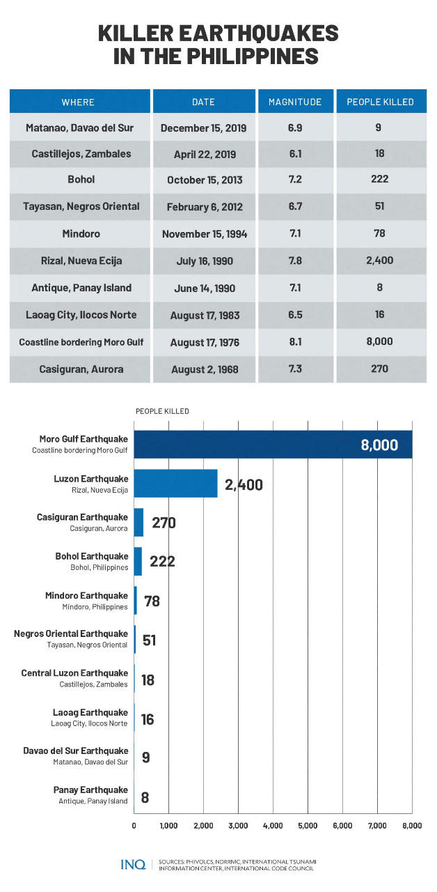
LIST: Killer earthquakes in the Philippines
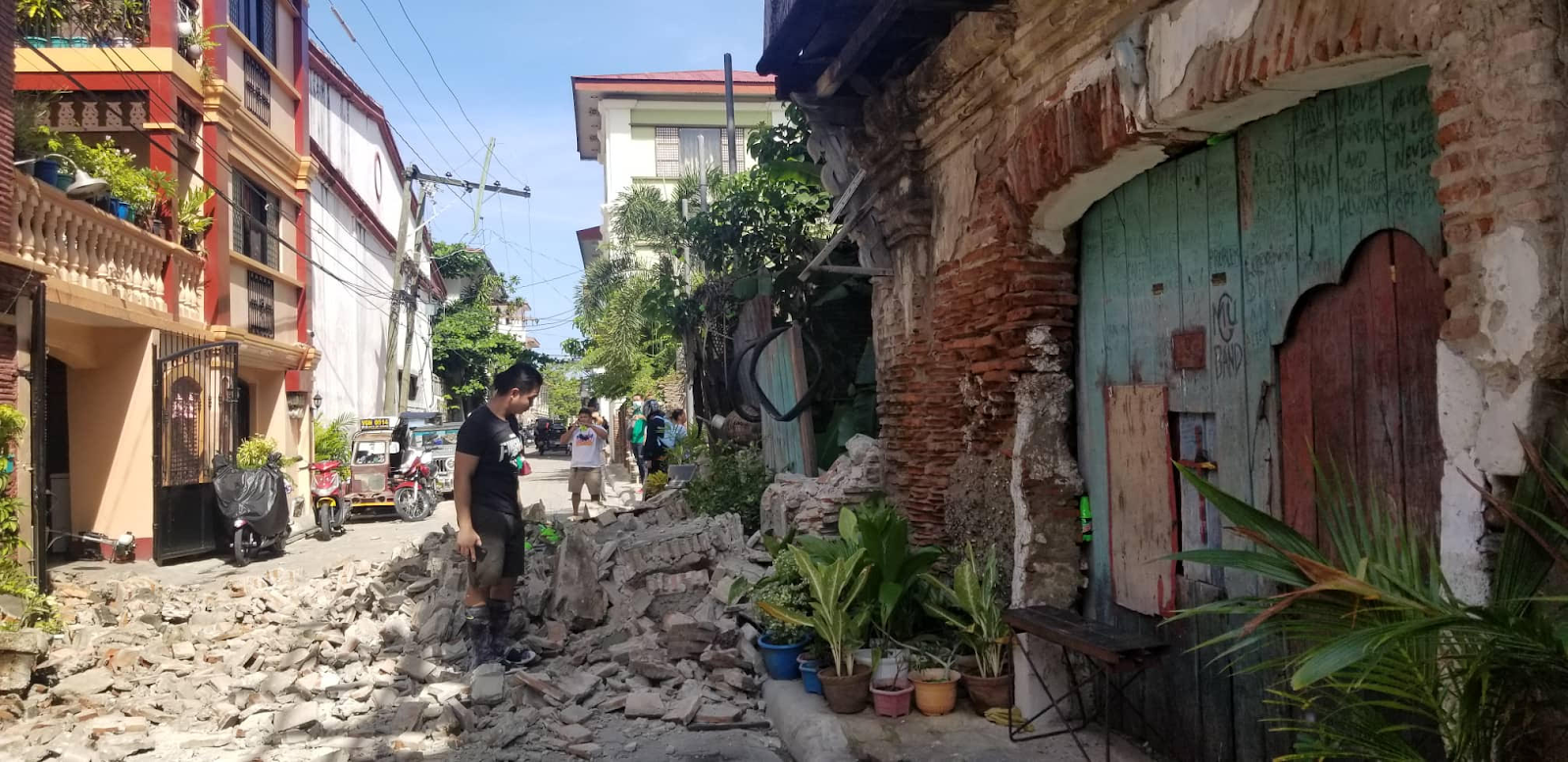
A heritage structure in Vigan City, Ilocos Sur is damaged by a 7.0 magnitude earthquake that hit Luzon on Wednesday morning (July 27). PHOTO COURTESY OF ARLENE GAJETON
MANILA, Philippines—As it is located in the “Pacific Ring of Fire,” the Philippines is at risk from earthquakes, with the Philippine Institute of Volcanology and Seismology (Phivolcs) saying that 100 to 150 earthquakes hit the country every year.
Last Wednesday (July 27), a magnitude 7.0 earthquake (earlier measured at 7.3) hit Tayum, Abra, prompting President Ferdinand “Bongbong” Marcos Jr. to order the immediate deployment of rescue and relief teams to Northern Luzon.
READ: Magnitude 7 earthquake jolts Abra, other parts of Luzon
The earthquake, which was strongly felt in Luzon, killed a construction worker in Barangay Buyagan, La Trinidad town, Benguet province, who was hit by falling debris from a building that collapsed when the earthquake struck.
READ: 1 dead as building collapses in Benguet town due to quake
Heritage structures in Vigan City, Ilocos Sur were also reported damaged by the earthquake, which struck at 8:43 a.m., and felt at different levels of intensities mainly in Northern Luzon and as far as Metro Manila.
READ: Heritage structures, churches damaged by 7.3 quake
- Intensity 7 – Bucloc and Manabo, Abra
- Intensity 6 – Vigan City, Sinait, Bantay, San Esteban, Ilocos Sur; Laoac, Pangasinan; Baguio City
- Intensity 5– Magsingal and San Juan, Ilocos Sur; Alaminos City and Labrador, Pangasinan; Bambang, Nueva Vizcaya; Mexico, Pampanga; Concepcion and Tarlac City, Tarlac; City of Manila; Malabon City
- Intensity 4 – Marikina City; Quezon City; Pasig City; Valenzuela City; Tabuk City, Kalinga; Bautista and Malasiqui, Pangasinan; Bayombong and Diadi, Nueva Vizcaya; Guiguinto, Obando, and San Rafael, Bulacan; San Mateo, Rizal
- Intensity 3 – Bolinao, Pangasinan; Bulakan, Bulacan; Tanay, Rizal
- Intensity 2 – General Trias City, Cavite; Santa Rosa City, Laguna
An earthquake, Phivolcs said, is “a weak to violent shaking of the ground produced by sudden movement of rock materials below the earth’s surface.” It said earthquakes originated in the tectonic plate boundary.
RELATED STORY: Earthquake damages structures, bridges in Abra town — initial reports
There are two ways by which we can measure the strength of an earthquake: magnitude and intensity. Magnitude is proportional to the energy released by an earthquake where its strength was most felt, while intensity is generally higher near the epicenter.
GRAPHIC: Ed Lustan
INQUIRER.net lists down some of the killer earthquakes that hit the Philippines, which is surrounded by active faults, like the West Valley Fault, which is 100 kilometers in length.
- Casiguran earthquake
A magnitude 7.3 earthquake with an intensity of 8 struck Casiguran, Aurora at 4:19 a.m. on Aug. 2, 1968, the most severe and destructive experienced in the Philippines then, leaving “several millions of pesos worth of damage.”
Phivolcs said 270 people were killed and 261 were injured as a result of the earthquake. A six-story building in Binondo, Manila collapsed instantly while some buildings near Binondo and Escolta in Manila sustained varying levels of structural damage.
“The cost of property damage was several million dollars. Extensive landslides and large fissures were observed in the mountainous part of the epicentral area. Tsunami was also observed and recorded as far as observations in tide gauge stations in Japan.”
- Moro Gulf earthquake
Phivolcs said that a few minutes after the stroke of midnight on Aug. 17, 1976, a magnitude 8.1 earthquake hit the island of Mindanao, triggering a tsunami that devastated more than 700 kilometers of the coastline bordering Moro Gulf in Celebes Sea. Damage was estimated at P6.7 billion.
It was an earthquake that resulted in massive destruction of properties and great loss of lives—8,000. Phivolcs said the tsunami was responsible for 85 percent of deaths, 65 percent of the injuries, and 95 percent of those missing.
“After the sea spent its fury and rolled back to its natural flow, thousands of people were left dead, others homeless or missing and millions of pesos lost with the damages of properties.”
Some of the structures damaged by the earthquake were the Notre Dame University, Dawns Hotel, Imperial Hotel, Melbourne Hotel, New Society Hotel, Cotabato Cinema, and the Immaculate Conception Church.
- Laoag earthquake
On Aug. 17, 1983, 8:18 p.m., a magnitude 6.5 earthquake with an intensity of 7 hit the province of Ilocos Norte, with a tremor that was perceptible over a distance of 400 kilometers from the epicenter.
Phivolcs said this was the most severe earthquake in northwestern Luzon in 52 years and probably the second strongest earthquake to hit Laoag City and its immediate vicinity.
This earthquake, which destroyed buildings in the province, left 16 people dead and 47 people wounded. The most heavily damaged structures in Laoag City are those near the Laoag River flood plain and along reclaimed stream channels.
“Several earthquake-induced landslides were observed in places where the slopes along road cuts were steep to very steep. This condition had been aggravated by prolonged rainy days, absence of vegetation to hold the soil, and moderately weathered rocks.”
- Panay earthquake
Panay Island was hit by a magnitude 7.1 earthquake on June 14, 1990, leaving eight people dead and 41 people wounded. Its epicenter was tagged in the vicinity of Culasi, Antique province.
The earthquake’s depth, Phivolcs said, was computed to be 15 kilometers and was generated by fault movement in the collisional zone off western Panay Island. An intensity of 7 was felt in Culasi, Antique and Libacao, Aklan.
Because of the earthquake, 15 percent of residential houses collapsed while the rest were damaged. Several commercial buildings, a school, a church, and bridges collapsed. Damage was estimated at P30 million.
- Luzon Earthquake
The International Code Council said the magnitude 7.8 earthquake that struck the island of Luzon on July 16, 1990, wreaked havoc across a sizeable portion of the island, the country’s largest, with Baguio City suffering the most devastating effects.
The epicenter of the earthquake, which struck at 4:26 p.m., was located in Rizal, Nueva Ecija. The shaking went on for nearly a full minute and collapsing buildings were the main cause of damage and death.
The earthquake resulted in a number of collapsed buildings, left an estimated $369 million worth of damage, and 2,412 people dead. It produced a 125-kilometer long ground rupture that stretches from Dingalan, Aurora to Kayapa, Nueva Vizcaya.
- Mindoro earthquake
According to the International Tsunami Information Center, a magnitude 7.1 earthquake hit Mindoro province on Nov. 15, 1994, leaving damage worth P67. 2 million. The earthquake generated a local destructive tsunami.
In Oriental Mindoro, the combined effects of the earthquake and the tsunami killed a total of 78 people, injured 430, damaged or destroyed 7, 566 houses in 13 out of 15 municipalities, damaged roads, destroyed or damaged 24 bridges, and sunk numerous fishing boats.
It said there was no time to issue a warning. Approximately five minutes after the tremor, tsunami waves struck along a 40-kilometer stretch of the northern and eastern shoreline of Mindoro island, from Puerto Galera up to Pinamalayan.
- Negros Oriental earthquake
A magnitude 6.7 earthquake shook the provinces of Negros and Cebu, and nearby islands of Western Visayas region at 11:49 a.m. on Feb. 6, 2012.
The earthquake was generated by a thrust fault movement with the epicenter located in Tayasan, Negros Oriental. An intensity of 8 was felt in Tayasan, Vallehermoso, Jimalalud, La Libertad, and Guihulngan, Negros Oriental.
The estimated cost of damage to infrastructure was P383 million. The earthquake left 51 dead and 112 injured, while 62 went missing from the landslide in Solongon, La Libertad and Planas, Guihulngan
Tsunami waves as high as five meters likewise struck Barangays Martilo, Pisong, and Magtalisay in La Libertad, Negros Oriental. Coastal areas of Negros Oriental from San Jose to Vallehermoso, and Cebu from Badian to Barili were also affected by the tsunami.
- Bohol earthquake
It was on Oct. 15, 2013 when a magnitude 7.2 earthquake struck the Visayas. The epicenter was located in Bohol in Central Visayas, but the shaking was felt as far as Southern Mindanao.
The earthquake affected over 1.2 million people, 222 people died, 976 were injured and eight people were missing. Over 79,000 structures including homes, roads, churches, schools and public buildings were damaged, according to a World Health Organization report. At least 14,500 of these structures were destroyed, the WHO report said.
The earthquake, which hit a month before Typhoon Yolanda (Haiyan) struck the Visayas, left damage worth P2.25 billion.
- Central Luzon earthquake
Zambales, Pampanga, and nearby provinces were hit by a magnitude 6.1 earthquake at 5:11 p.m. on April 22, 2019, leaving damage to infrastructure worth P539 million.
The epicenter was located 18 kilometers east of Castillejos, Zambales, on a mountainous area, at a depth of 10 kilometers. Small-magnitude earthquakes followed afterwards, and as of 8:00 a.m. of 23 April 2019, 421 aftershocks have been recorded.
The earthquake left 18 people dead, 256 people injured, while three people went missing.
- Davao del Sur earthquake
At 2:11 p.m. on Dec. 15, 2019, a magnitude 6.9 earthquake shook the province of Davao del Sur and its vicinity. The earthquake’s epicenter was located nine kilometers northwest of Matanao, Davao del Sur, at a depth of three kilometers.
This earthquake followed the recent earthquake events on July 9, 2019 and Oct. 16 2019. After this, a total of 530 small to moderate magnitude earthquakes have been recorded.
The National Disaster Risk Reduction and Management Council said the earthquake left nine dead and injured hundreds of people. Damage was estimated at P4.55 million.