No back-to-back storms seen after Ulysses but Pacific Ocean still restless

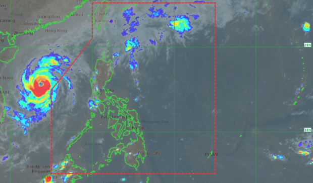
A welcome weather development: No impending storm is seen by Pagasa. 5 p.m. satellite image from Himawari-IR1 via Pagasa
MANILA, Philippines — Weather over most parts of Luzon is seen to improve as Typhoon Ulysses continues to move away from the country, and with state meteorologists not spotting any system that may threaten the country.
The Philippine Atmospheric, Geophysical and Astronomical Services Administration (Pagasa) said that they have not seen any low-pressure area nearby — but warned that the Pacific Ocean remains active and may create another low pressure without warning.
The break from the weather disturbances would be much welcomed in the country after Ulysses and Rolly wreaked havoc on the Bicol Region, Southern Luzon, Central Luzon, Metro Manila, and parts of northern Luzon.
“Isang magandang balita ang nakikita natin, so in the next three to five days ay wala naman tayong inaasahan na bagyo o sama ng panahon na maaaring mabuo o pumasok ng ating area of responsibility,” weather specialist Raymond Ordinario said.
(Good news for us as we have not seen any low-pressure area or storm to enter the country’s area of responsibility in the next three to five days.)
Article continues after this advertisement“Ngunit ‘wag tayong maging kampante dahil hanggang ngayon ay aktibo pa rin itong ating Karagatang Pasipiko at pwede pa rin ‘to, anytime, mag-form o makabuo ng anumang sama ng panahon o low pressure area,” he added.
Article continues after this advertisement(But we should not be complacent as up to now, the Pacific Ocean remains active which means low-pressure areas may form anytime.)
In just a month’s time — between October 11 to Thursday, November 12 — eight cyclones have already entered the Philippine area of responsibility (PAR). There were even two instances where two cyclones were inside PAR at the same time.
All but one — Tropical Depression Nika — made landfall. But apart from Nika, all the other cyclones, from Ofel, Pepito, Quinta, Rolly, Siony, Tonyo, and just recently Ulysses, have hit land.
Like Ulysses, the majority of these storms’ track came from the eastern part of the country, from Eastern Visayas, Bicol Region, eastern parts of Quezon, and Cagayan Valley, crossing the Luzon landmass.
Just last November 1, Rolly — which made landfall as a super typhoon — caused extensive damage in Camarines Sur, Catanduanes, and Albay.
Ulysses left PAR around Friday afternoon, and from a severe tropical storm, it has re-intensified into a typhoon. Although the storm is afar, strong winds may lash the Northern Luzon areas due to the northeast monsoon or amihan.
Weather forecasts for most of Luzon would be generally fair except for Northern Luzon which will see cloudy skies. Temperatures over Metro Manila, Laoag, Legazpi, and Palawan may range from 25 to 32 degrees Celsius, while it would be colder in Tuguegarao with 23 to 30 degrees.
The same hot and humid scenarios will prevail in Visayas and Mindanao, with temperatures in Iloilo, Cebu, and Tacloban playing between 25 to 32 degrees Celsius, 25 to 34 degrees in Davao, and 24 to 33 degrees in Zamboanga.
Gale warnings are still raised over the northern seaboards of Cagayan Valley including the Batanes Group of Islands, plus western waters of Ilocos Region. Small boats are not allowed to set sail in the said areas as sea conditions may be rough to very rough. [ac]
RELATED STORIES