‘Helen’ enters PH; moderate to heavy rains expected | Inquirer News

‘Helen’ enters PH; moderate to heavy rains expected
By: - Reporter / @NCorralesINQ
/ 05:39 PM September 24, 2016

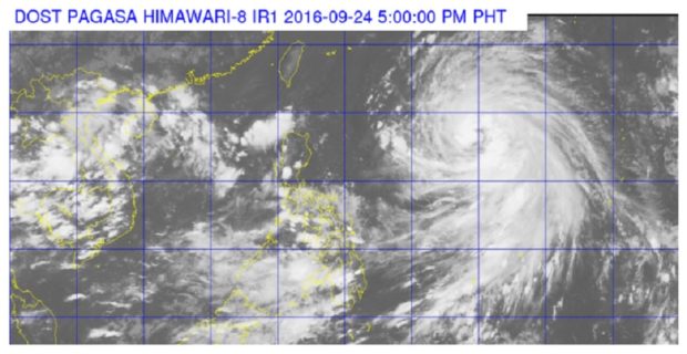
storm-helen-as-of-5pm-september-24-2016Severe Tropical Storm “Megi” on Saturday afternoon entered the Philippine area of responsibility, the state weather bureau said.

The Philippine Atmospheric, Geophysical and Astronomical Services Administration (Pagasa) said Megi, now locally named “Helen,” was last spotted 1,390 kilometers east northeast of Casiguran, Aurora, at 4 p.m.

Pagasa said Helen was forecast  to move west northwest at 25 kph. The storm packed maximum sustained winds of up to 110 kph near the center and gustiness of up to 140 kph.

Article continues after this advertisement

The weather bureau said no tropical cyclone signal was raised in any provinces but warned of moderate to heavy rains.

FEATURED STORIES

Estimated rainfall amount is from moderate to heavy rains within 600 km diameter of the storm.

Helen would be the third weather disturbance to affect northern Luzon in two weeks once it enters Philippine area of responsibility. Northern Luzon was earlier hit by Typhoons “Ferdie” (Meranti) and “Gener” (Malakas).

Article continues after this advertisement

RELATED STORY

‘Megi’ upgraded into severe tropical storm as it nears PAR

Your subscription could not be saved. Please try again.
Your subscription has been successful.

Subscribe to our daily newsletter

By providing an email address. I agree to the Terms of Use and acknowledge that I have read the Privacy Policy.

TAGS: News, Typhoon, Typhoon Helen, Typhoon Megi, Weather

Your subscription could not be saved. Please try again.
Your subscription has been successful.

Subscribe to our newsletter!

By providing an email address. I agree to the Terms of Use and acknowledge that I have read the Privacy Policy.

© Copyright 1997-2024 INQUIRER.net | All Rights Reserved

This is an information message

We use cookies to enhance your experience. By continuing, you agree to our use of cookies. Learn more here.