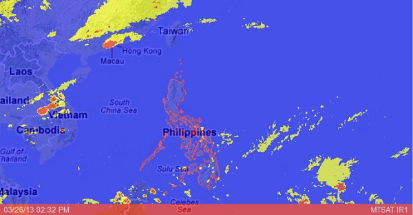
New low pressure area to bring rains in the south around Easter time
MANILA, Philippines—Expect sunny weather from Maundy Thursday to Good Friday, but Black Saturday and Easter may be somewhat wet, especially in the southern parts of the country, due to an approaching low pressure area, the state weather bureau said.
In a special weather outlook for Holy Week, the Philippine Atmospheric, Geophysical and Astronomical Services Administration predicted good weather conditions with warm and humid temperatures to prevail from Thursday to Friday.
But a low pressure area spotted east of the Philippines will approach southeastern Mindanao in the morning of Black Saturday and will make landfall in the evening, bringing light to moderate rain showers and thunderstorms over the entire island of Mindanao, Pagasa said.
The rains will be moderate to heavy in the Caraga and Davao regions, it added.
“The LPA will then move toward Central Visayas, crossing the area on Easter Sunday (March 31) and is expected to bring light to moderate rainshowers and thunderstorms over Southern Luzon, Visayas and Mindanao becoming moderate to heavy rains over Western Visayas,” Pagasa said.
Article continues after this advertisementMeanwhile, the diffused tail-end of a cold front will bring occasional light to moderate rainshowers and thunderstorms over Cagayan Valley,
Article continues after this advertisementCentral Luzon and Quezon province until Wednesday morning.
Pagasa said coastal waters throughout the archipelago will be generally slight to moderate except during thunderstorms throughout the outlook period with the exception of the northern seaboard of Northern Luzon, which will have moderate to rough seas Tuesday and Wednesday.
Based on recent analysis of all available forecasting tools, the low pressure area has only a slim chance of developing into a tropical cyclone, Pagasa said.
