Pepito now a typhoon; Ofel lowers strength to severe tropical storm

Severe Tropical Storm Pepito (international name: Man-yi) gathers more strength and is now a typhoon, according to the Philippine Atmospheric, Geophysical and Astronomical Services Administration (Pagasa). In a bulletin on Friday, November 15, 2024, the state weather agency also said Typhoon Ofel (International name: Usagi) reduced its strength to a severe tropical storm as it moved away from Northern Luzon, although wind signals remain for some areas in the region. Photo from Pagasa
MANILA, Philippines — Severe Tropical Storm Pepito (international name: Man-yi) gathered more strength and is now a typhoon, according to the Philippine Atmospheric, Geophysical and Astronomical Services Administration (Pagasa).
Pepito’s further development comes as Typhoon Ofel (international name: Usagi) reduced its strength to a severe tropical storm as it moved away from Northern Luzon, although wind signals remain for some areas in the region.
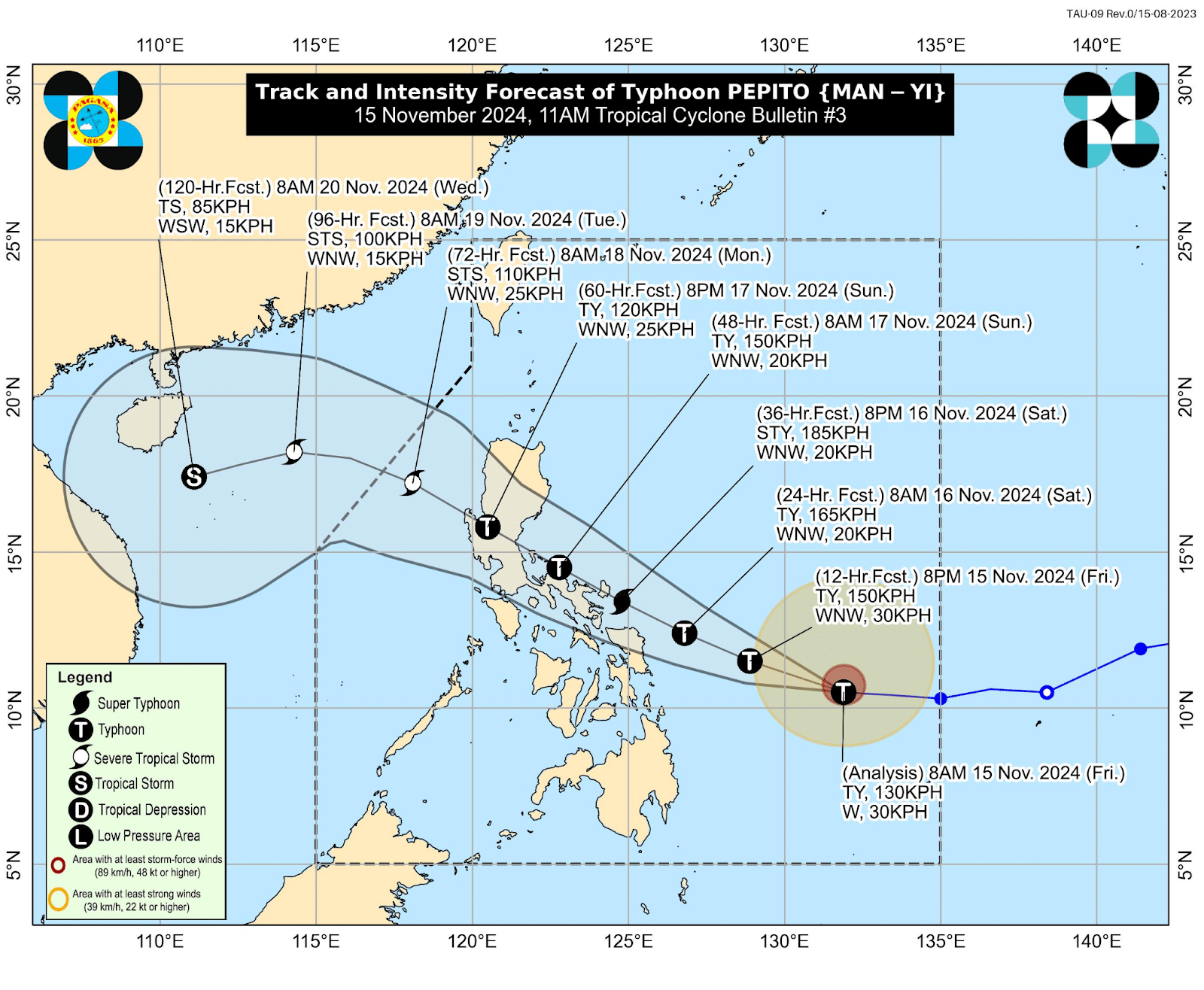
Pagasa said Pepito reached the typhoon category Friday morning, packing maximum sustained winds of 130 kilometers per hour (kph) and gustiness of up to 160 kph at its last location – 630 kilometers east of Guiuan, Eastern Samar.
Pepito was moving westward at 30 kph.
READ: Bicol, still reeling from Kristine, is on path of Pepito
Article continues after this advertisementAccording to Pagasa, Pepito is seen to make landfall in the vicinity of Catanduanes either Saturday evening (November 16) or Sunday early morning (November 17). And regardless of its landfall point, Pepito is expected to move generally west-northwestward.
Pagasa’s track projection indicates that Pepito will pass through the Bicol Region, Quezon province, Central Luzon, and Pangasinan province, and cross the West Philippine Sea by Sunday evening or Monday morning (November 18).
Earlier, Pagasa specialist Dan Villamil said during a weathercast that some areas may start to feel Pepito’s wind strength in 36 hours. He also said that Pepito may make landfall at peak intensity.
He added that Pagasa may raise the highest Tropical Cyclone Wind Signal (TCWS) No. 5 for Pepito.

Typhoon Pepito (international name: Man-yi) track and intensity, 11 a.m., Friday, November 15, 2024. Photo from Pagasa
For Friday, however, as Pepito intensified into a typhoon, Pagasa issued the following Tropical Cyclone Wind Signals:
TCWS No. 2
Northern Samar
- Mapanas
- Gamay
- Palapag
- Lapinig
Eastern Samar
- Arteche
- Oras
- San Policarpo
- Dolores
- Jipapad
- Maslog
TCWS No. 1
Luzon
- Southeastern portion of Quezon
- Camarines Norte
- Camarines Sur
- Catanduanes
- Albay
- Sorsogon
- Masbate
Visayas
- Rest of Northern Samar
- Rest of Eastern Samar
- Samar
- Biliran
READ: Pepito prompts Signal No. 2 in Northern and Eastern Samar

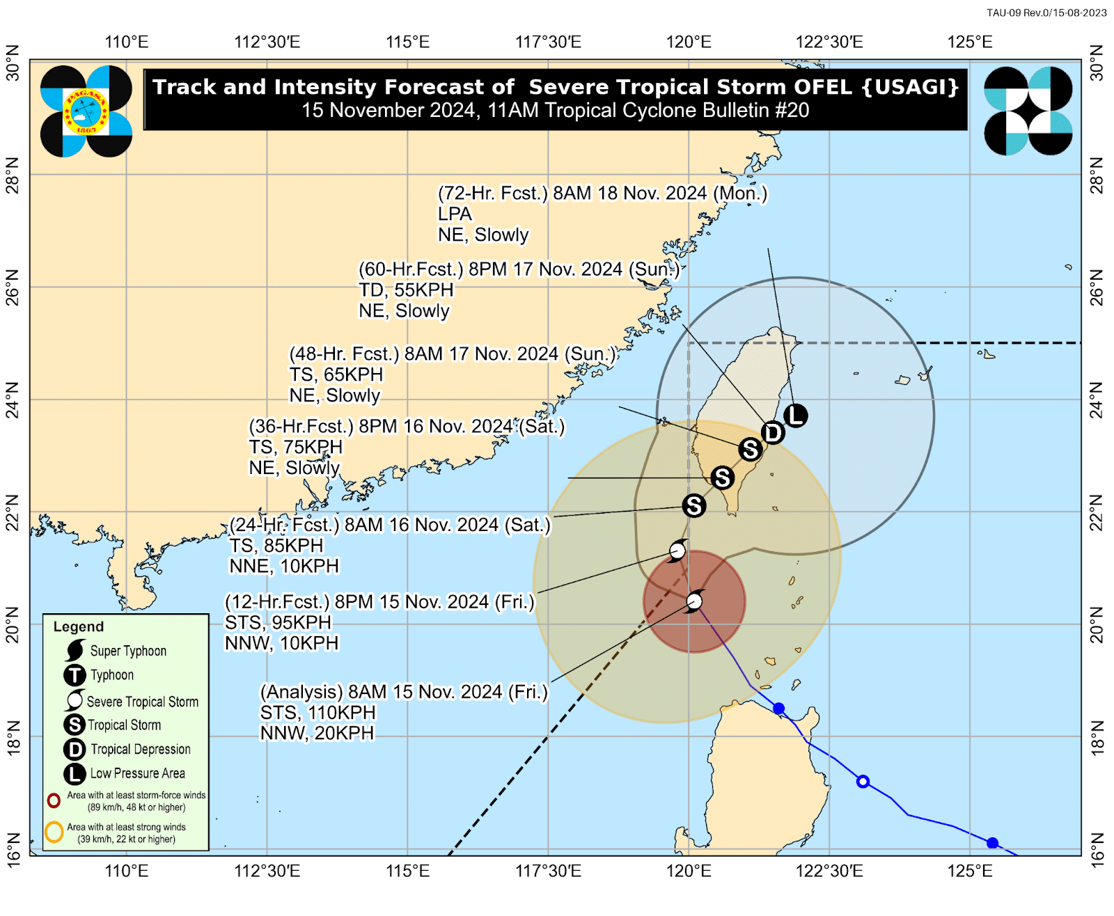
Severe Tropical Storm Ofel (international name: Usagi) track and intensity, 11 a.m., Friday, November 15, 2024. Photo from Pagasa
As for Ofel, the state weather agency said it was packing maximum sustained winds of 110 kph with gustiness of up to 135 kph, as it moved north-northwestward at 20 kph.
The now-severe tropical storm was last located 215 kilometers northwest of Calayan, Cagayan.
Pagasa said Ofel will continue to move north-northwestward and leave the Philippine area of responsibility (PAR) by Friday afternoon, November 15.
But Pagasa likewise said Ofel may re-enter the PAR.
“Outside PAR, the tropical cyclone will then move generally northward until tomorrow [Saturday, November 16] early morning over the sea west of Batanes. Ofel may then re-enter the PAR region as it turns generally northeastward towards southern Taiwan and will remain inside PAR until the rest of the forecast period,” the state weather agency explained.
In the meantime, TCWS No. 2 was hoisted over Batanes due to Ofel as of 11 a.m., Friday.
Pagasa also raised TCWS No. 1 due to Opel in the following areas:
- Northern portion of Cagayan (Pamplona, Claveria, Abulug, Sanchez-Mira, Santa Praxedes, Ballesteros)
- Babuyan Islands
- Northern portion of Apayao (Luna, Santa Marcela, Calanasan)
- Northern portion of Ilocos Norte (Pagudpud, Adams, Bangui, Dumalneg, Burgos, Pasuquin, Vintar, Bacarra, Piddig, Carasi)