Pagasa warns: Pepito a very dangerous cyclone

Track of Typhoon Pepito (international name Man-yi) as of Nov. 15, Friday. Image from DOST / Pagasa
MANILA, Philippines – The state weather bureau on Friday cautioned the public that Pepito (international name Man-yi), which intensified into a typhoon, is a very dangerous tropical cyclone.
“The next 24 hours are critical. Pepito moves really fast at 30 kph (kilometers per hour) Lubhang mapanganib ito (It’s very dangerous),” Philippine Atmospheric, Geophysical and Astronomical Services Administration (Pagasa) Administrator Nathaniel Servando said in a briefing before noon.
The typhoon packs maximum sustained winds of 130 kph near the center and gustiness of up to 160 kph. It could reach the super typhoon category prior to making a landfall on Saturday night or early Sunday.
Pepito was located 630 km east of Guiuan, Eastern Samar as of 10 a.m.
“It is forecast to further intensify as goes nearer the landmass. Torrential rains could result in floods, landslides and storm surge,” Servando said.
He added that areas that are likely to be affected are Eastern Visayas, Bicol Region Central Luzon and Quezon.
In the same briefing, Pagasa forecaster Glaiza Esculiar said Pepito could possibly make a landfall over Catanduanes this weekend.
However, she noted that Samar provinces, Bicol Region, Mimaropa and parts of Central Luzon should also be prepared as these areas are included in Pepito’s forecast track.
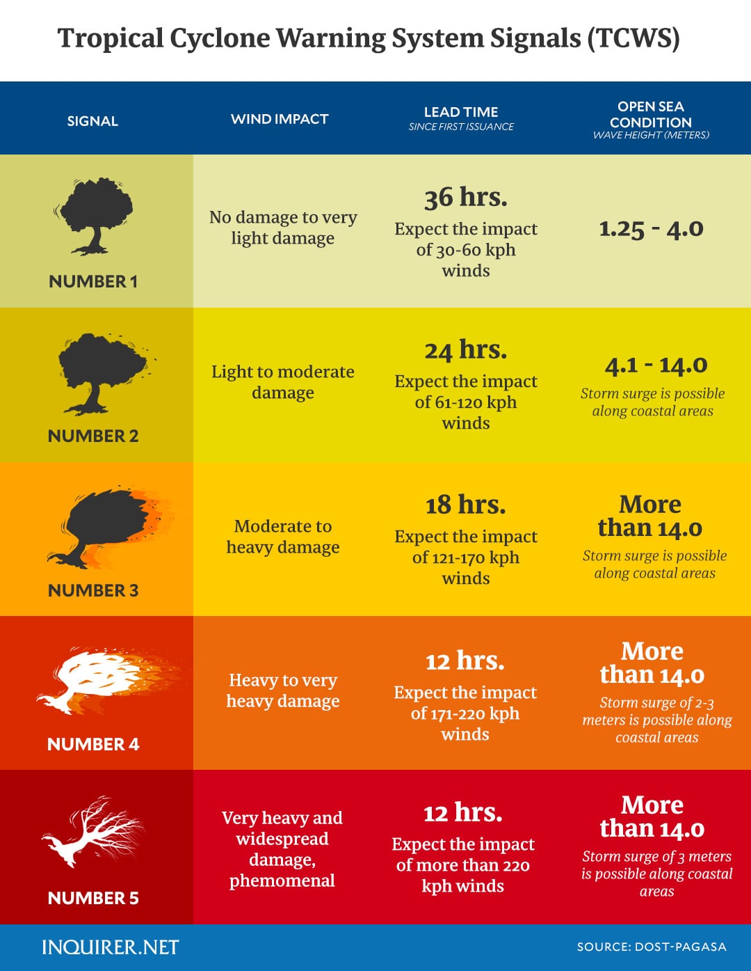
Meanwhile, as of 11 a.m., tropical cyclone wind signal (TCWS) No. 2 is hoisted over these areas:
- The eastern portion of Northern Samar (Mapanas, Gamay, Palapag, Lapinig)
- The northern portion of Eastern Samar (Arteche, Oras, San Policarpo, Dolores, Jipapad, Maslog)
TCWS No. 1 is hoisted over these areas:
- The southeastern portion of Quezon
- Camarines Norte
- ]Camarines Sur
- Catanduanes
- Albay
- Sorsogon
- Masbate
- Rest of Northern Samar, the rest of Eastern Samar, Samar, and Biliran

Batanes will experience moderate to heavy rains on Friday, while intense to torrential rains are forecast in Catanduanes, Albay, Sorsogon, and Northern Samar on Saturday.
There is a moderate to high risk of life-threatening storm surge with peak heights reaching three meters above normal tide levels in the next 48 hours over the low-lying or exposed coastal localities of southeastern Quezon, Camarines Sur, Catanduanes, Albay, Sorsogon, northern Masbate including Burias and Ticao Islands, Northern Samar, Eastern Samar, Samar, and northern Biliran.
Ofel weakens further
Meanwhile, Ofel (international name Usagi) has further weakened into a severe tropical storm, packing maximum sustained winds of 110 kph near the center and gustiness of up to 135 kph.
READ: Pepito now a typhoon; Ofel lowers strength to severe tropical storm
Ofel was located 215 km northwest of Calayan, Cagayan or 195 km west of Itbayat, Batanes as of 10 a.m.
Batanes is under TCWS No. 2 while TCWS no. 1 is hoisted over these areas:
- Northern portion of Cagayan (Pamplona, Claveria, Abulug, Sanchez-Mira, Santa Praxedes, Ballesteros)
- Babuyan Islands, the northern portion of Apayao (Luna, Santa Marcela, Calanasan)
- Northern portion of Ilocos Norte (Pagudpud, Adams, Bangui, Dumalneg, Burgos, Pasuquin, Vintar, Bacarra, Piddig, Carasi)
Gale warning is hoisted over the northern seaboard of Northern Luzon.
Esculiar said Ofel might exit the Philippine area of responsibility on Saturday afternoon.
Ofel is forecast to make a landfall over Taiwan and weaken into a low-pressure area. Its reentry to the PAR in the next few days is possible, Esculiar said.


