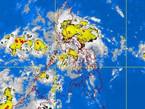
Rain in Luzon, Visayas due to intertropical convergence zone–Pagasa
MANILA, Philippines — An intertropical convergence zone in Luzon and Visayas is expected to bring rain in these areas, the Philippine Atmospheric, Geophysical and Astronomical Services Administration said Friday.
There will be cloudy skies with scattered rainshowers and thunderstorms over the eastern section of Central and Southern Luzon, which may trigger floods and landslides, it also said.
Moderate to strong winds blowing from the East to Northeast will also prevail over Luzon while its coastal waters will be slight to moderate.
Meanwhile, light to moderate winds will be blowing from the East and Southeast over Visayas and Mindanao, the state-run weather bureau said.
The coastal waters along these areas will be slight to moderate, it added.
Article continues after this advertisementThe strong to gale force wind that is expected to affect the seaboards of Northern Luzon and the Eastern seaboards of Central and Southern Luzon has prompted Pagasa to issue an advisory to owners of fishing boats and other small seacraft not to venture out into the sea and for larger vessels to watch out for the big waves.
