LPA intensifies into tropical depression, nears PAR
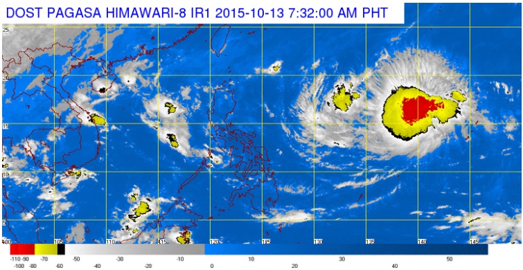
SATELLITE IMAGE FROM PAGASA
The low pressure area (LPA) tracked by the weather bureau has intensified into a tropical depression late Monday.
The cyclone, which will be called “Lando” when it enters the Philippine area of responsibility on Wednesday night or Thursday morning, was last spotted 2,535 kilometers east of Luzon, the Philippine Atmospheric, Geophysical and Astronomical Services Administration (Pagasa) said on Tuesday.
READ: Pagasa: Possible cyclone may enter PAR Wednesday | Cyclone may be coming
Aldczar Aurelio of Pagasa said by phone that there are chances that the cyclone will intensify further as it remained at sea.
The tropical depression moved west northwest at 25 kph and packed maximum sustained winds of 45 kph.
Article continues after this advertisementAurelio couldn’t say yet if the tropical depression would make landfall, but said that cyclones at this time of the year usually hit land.
Article continues after this advertisementA tail-end of a cold front is affecting extreme Northern Luzon.
Cloudy skies with light to moderate rains and isolated thunderstorms will be experienced over the provinces of Ilocos Norte, Apayao, Cagayan, Isabela, Aurora, Quezon and the islands of Batanes, Calayan and Babuyan.
Partly cloudy to cloudy skies with isolated thunderstorms will prevail over Metro Manila and the rest of the country. IDL