North Luzon residents brace for stormy weekend
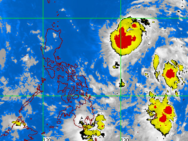
MTSAT-EIR Satellite Image for 1 a.m., 30 September 2011
They may still be reeling from the effects of Typhoon “Pedring,” but residents of extreme northern Luzon are in for a potentially stormy weekend.
Tropical Storm “Quiel” (international name: Nalgae) is forecast to hit land between Batanes and Cagayan provinces on Sunday night at its current speed and direction, and can intensify into a typhoon over the sea before landfall, the Philippine Atmospheric Geophysical and Astronomical Services Administration (Pagasa) said.
Now classified as a severe storm, Quiel is packing maximum winds of 110 kilometers per hour and gusts of up to 140 kph, forecaster Aldczar Aurelio said Thursday in an interview.
But Quiel’s impact on extreme northern Luzon will not be felt until it swirls close to Cagayan on Sunday morning, he said.
“Extreme northern Luzon, including Cagayan, Batanes and Ilocos Norte, should brace for moderate to heavy rain with gusty winds,” Aurelio said.
Article continues after this advertisementHe said Quiel was “destructive” and packed “a stronger punch” because its 300-km diameter was more compact than Pedring’s 650-km diameter.
Article continues after this advertisementThis early, Pagasa said, residents of the cited areas should pack provisions in a bag. It also said that those living close to areas prone to landslides and floods should move to safer ground, and that local government units should implement contingency measures.
Less than typhoon
Quiel swirled into the Philippine area of responsibility from the Pacific Ocean at around 4 a.m. Thursday. Initially packing winds of 105 kph and gusting up to 135 kph, the storm slightly intensified over the Philippine Sea.
At its current strength of 110 kph in maximum winds, Quiel is a shade shy of a typhoon’s winds of 120 kph.
By 10 a.m. Thursday, Quiel was swirling over the Philippine Sea some 1,150 km east of Aparri, Cagayan. At a speed of 13 kph, it was moving westward toward Aparri. Friday morning, it was forecast to be 870 km east of Aparri.
But Quiel is yet too far to affect the archipelago. Between now and Sunday, the weather will be “fine for most parts of the country,” Aurelio said.
And a low-pressure area earlier spotted over the Pacific Ocean has dissipated, according to Pagasa.
But in central and northern areas of Luzon, residents continued to grapple with the aftermath of Pedring (international name: Nesat).
The typhoon unleashed powerful winds and heavy rain, knocking down power lines and trees, triggering floods and mudslides, and spawning storm surges and swelling rivers before exiting on Wednesday afternoon toward southern China.
A number of towns in the northern Luzon provinces remained submerged in floodwaters, and thousands of residents remained cooped up in evacuation centers.
Pedring damaged close to P1 billion worth of crops, fisheries and livestock, and infrastructure.
‘Ramon’ dissipated
Earlier Thursday, the province of Albay began stockpiling food and tracking the low-pressure area that was to be named “Ramon.”
Albay Governor Joey Salceda had expressed apprehension that the low-pressure area would be relatively strong. It had been projected to head toward the Bicol region and to directly affect the province, as indicated in the meteorological models and tracks prepared by Pagasa. With a report from Rey M. Nasol, Inquirer Southern Luzon