The Philippine Atmospheric Geophysical and Astronomical Services Administration said Ruby, spotted moving west northwest at 10 kph, packed maximum sustained winds of 105 kilometers per hour near the center and gusts of up to 135 kph.
Ruby’s next landfall is expected in Torrijos, Marinduque between 11 a.m. to 12 noon.
Its next landfall is between 6 to 9 p.m. in Batangas.
The storm was last observed 20 kilometers east of Torrijos. Moderate to heavy rains are seen within its 450-kilometer diameter.
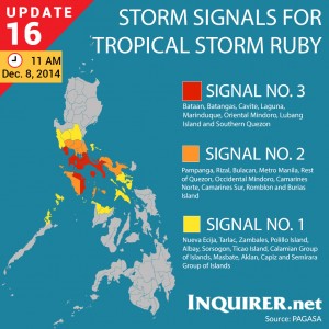
Storm signals were raised in the following areas:
PUBLIC STORM WARNING SIGNAL #3
(Winds of 101-185 kph is expected in at least 18 hrs)
Bataan, Batangas, Cavite, Laguna, Marinduque, Oriental Mindoro, Lubang Island and Southern Quezon.
PUBLIC STORM WARNING SIGNAL #2
(Winds of 61-100 kph is expected in at least 24 hrs)
Pampanga, Rizal, Bulacan, Metro Manila, Rest of Quezon, Occidental Mindoro, Camarines Norte, Camarines Sur, Romblon and Burias Island.
PUBLIC STORM WARNING SIGNAL #1
(Winds of 30-60 kph is expected in at least 36 hrs)
Nueva Ecija, Tarlac, Zambales, Polillo Island, Albay, Sorsogon, Ticao Island, Calamian Group of Island and Masbate, Aklan, Capiz and Semirara Island.
Ruby is expected to exit the Philippine area of responsibility by Thursday morning.
RELATED STORIES
‘Orange’ rainfall warning up over Metro, Calabarzon areas
‘Ruby’ weakens; Metro Manila braces for rains, storm surges