‘Glenda’ further intensifies; Signal No. 3 up in Catanduanes

Storm clouds hover above Mt. Isarog in Camarines Sur on Monday, a day before tropical storm Glenda was expected to make landfall in Bicol region. Photo by Juan Escandor, Inquirer Southern Luzon
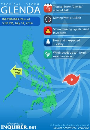
MANILA, Philippines — Tropical Storm “Glenda” further intensified as it changed its course Monday afternoon, prompting the weather bureau to hoist public storm warning signals in Luzon and Visayas provinces including Metro Manila.
In a press briefing, weather forecaster Jori Luiz of the Philippine Atmospheric, Geophysical and Astronomical Services Administration said Glenda was last seen at 470 kilometers east southeast of Virac, Catanduanes or 500 km east of Legazpi, Albay.
Glenda has also upped its strength with maximum sustained winds of 110 kilometers per hour near the center and gusts of 140 kph from its previous strength of 95 kph near the center and 120 kph gusts.

“Actually it’s just one step behind being a typhoon,” Ruiz said.
Article continues after this advertisementCatanduanes was placed under Signal No. 3 while Signal No. 2 was hoisted over Camarines Sur, Camarines Norte, Albay, Masbate including Burias and Ticao Islands, Sorsogon, Marinduque, southern Quezon, and northern Samar.
Article continues after this advertisementMeanwhile, Signal No. 1 was raised in Romblon, Oriental Mindoro, Occidental Mindoro, Lubang Island, Batangas, Cavite Laguna, Rizal, Bulacan, Pampanga, Bataan, Zambales, Tarlac, Nueva Ecija, Pangasinan, southern Aurora, northern Quezon including Polilio Islands, Eastern Samar, Biliran, Samar, and Metro Manila.
Metro Manila will be on the course of Glenda with the cyclone hitting the capital Wednesday 2 a.m. Its effects will be experienced starting Tuesday afternoon.
Glenda is set to move out of the Philippine landmass between the Batanes and Zambales area Wednesday noon and out of the Philippine Area of Responsibility by Thursday noon.
RELATED STORIES
Coast Guard units on heightened alert for ‘Glenda’
Classes suspended in Albay due to ‘Glenda’
Signal No. 2 raised in five provinces, Signal No. 1 in Metro Manila due to ‘Glenda’