‘Santi’ exits PH
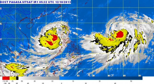
MANILA, Philippines – Typhoon “Santi” careened through Luzon “like a spinning top” after it made landfall Friday night, moving faster than expected and out into the West Philippine Sea by Saturday, the state weather bureau said.
The Philippine Atmospheric, Geophysical and Astronomical Services Administration (Pagasa) lifted public storm warnings in all provinces except Zambales and Bataan, which remained under Signal No. 1, indicating wind speeds of 30-60 kilometers per hour, as of mid-Saturday.
The typhoon struck land before midnight Friday in Aurora and cut through Central Luzon at speed of 22 kph, a speed much faster than earlier expected, Pagasa forecaster Gladys Saludes said.
“The typhoon interacted with the mountain ranges of Aurora. The effect was like a spinning top that was bouncing from one (place) to the next. That was the reason it left the Luzon landmass earlier than expected,” she added.
As of 11 a.m. Saturday, the eye of the typhoon was already out at sea, some 100 kilometers west of Iba, Zambales, Pagasa said.
Article continues after this advertisementAs it passed, the storm had gusts of up to 180 kph and dumped heavy to torrential rain over large areas of Luzon, prompting Pagasa to issue consecutive rainfall warnings in several provinces in Central and Southern Luzon.
Article continues after this advertisementBy midday, however, Santi had lost some of its strength, packing peak sustained winds of 120 kph near the center and and gusts of up to 150 kph. On Friday night, its sustained wind velocity was 150 kph with gusts of up to 180 kph.
The typhoon was forecast to move westward at 19 kph and to be out of the Philippine area of responsibility by Sunday morning.
But sea travel remains risky off the coasts of Luzon as well as in the Visayas, Pagasa said in an advisory.
Saludes said a tropical depression brewing in the Pacific Ocean had developed into a storm, and was expected to enter the Philippine area of responsibility by Monday morning.
The storm is not expected to make landfall anywhere in the country, and will likely only graze the northern parts as it heads for Japan, she said.
RELATED STORIES
5 killed, 2.1M without power as ‘Santi’ slams Luzon
