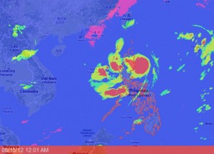
‘Helen’ gets stronger, might make landfall on Isabela-Cagayan area
MANILA, Philippines—At 9 p.m. Tuesday, the center of Tropical Storm “Helen” was observed at 120 km East Southeast of Tuguegarao City, according to Pagasa.
The storm has accelerated and is expected to make landfall over the Isabela-Cagayan area within 24 hours, the weather bureau said.
Public Storm Signal No. 2, indicating winds of 61-100 kph, was hoisted over Cagayan, including Calayan and Babuyan Group of Islands, Isabela, Northern Aurora, Quirino, Nueva Vizcaya, Benguet, Ifugao, Mt.
Province, Ilocos Sur, Apayao, Kalinga, Ilocos Norte, Abra and Batanes.
On the other hand, Signal No. 1, with winds of 30 kph to 60 kph, was raised over Nueva Ecija, Pangasinan, Tarlac, La Union, and the rest of Aurora.
Estimated rainfall amount is from 20 mm – 35 mm per hour (intense-torrential) within the 500 km diameter of the storm.
Moderate to heavy rains (7.5 – 10.0 mm/hr) are expected in Quezon province, Rizal, Bulacan, Pampanga, Laguna, Cavite, Batangas, Mindoro, Bataan, Zambales, Pangasinan, Tarlac and Metro Manila becoming intermittent light to moderate rains (2.5 – 7.5 mm/hr) over the rest of Central and Southern Luzon.
