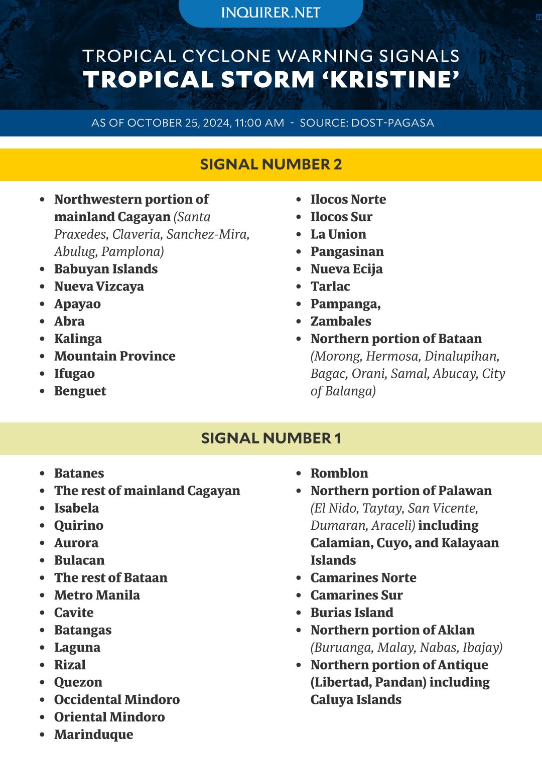
Signal No. 1 in Metro Manila, Signal No. 2 in 18 areas amid Kristine
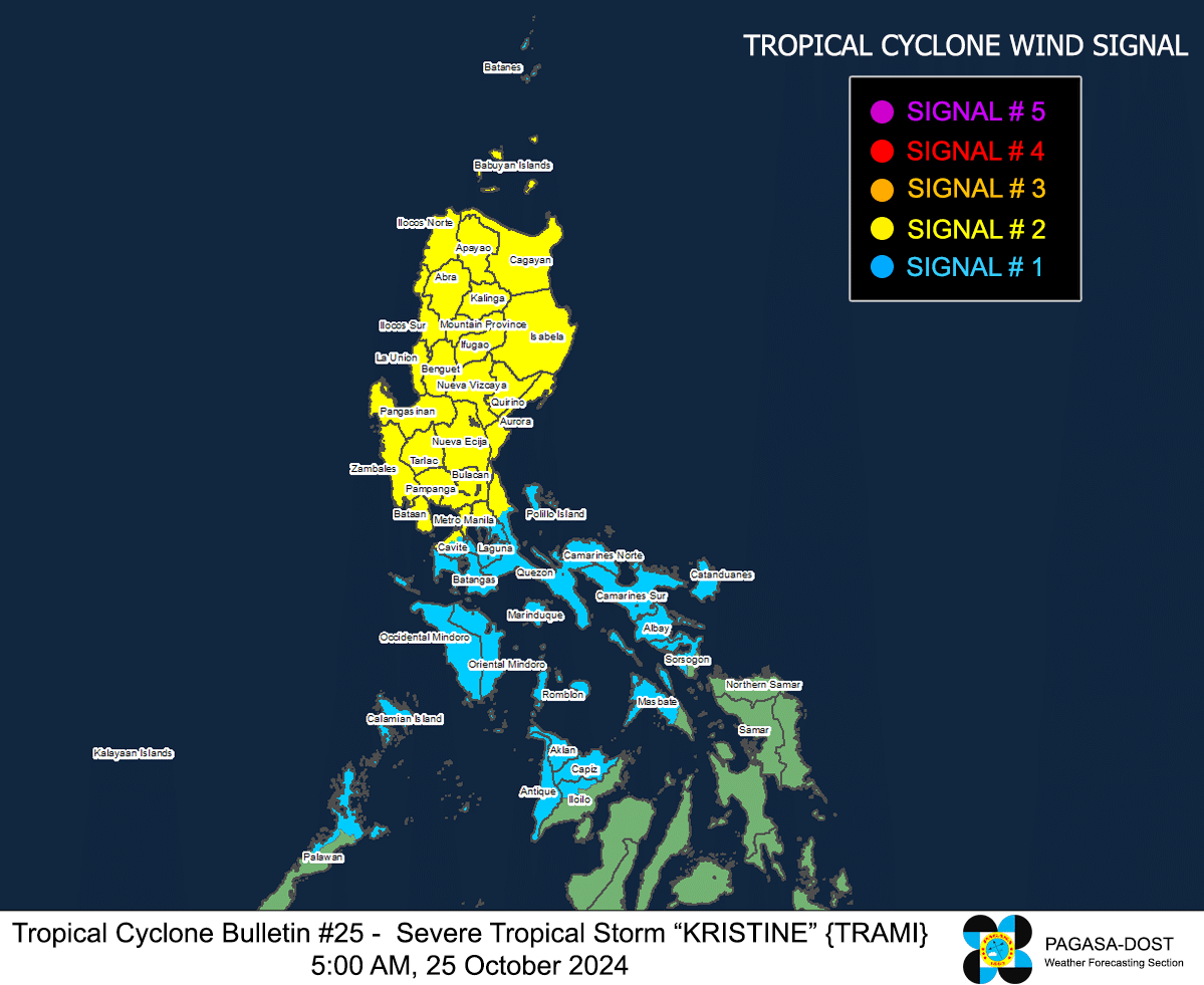
MANILA, Philippines – Metro Manila is now under Tropical Cyclone Wind Signal (TCWS) No. 1 as Severe Tropical Storm Kristine (international name: Trami) is set to exit the Philippine area of responsibility on Friday afternoon, October 25.
Meanwhile, 18 areas in Luzon are still under Signal No. 2, according to the Philippine Atmospheric, Geophysical and Astronomical Services Administration’s (Pagasa) 11 a.m. bulletin.
GRAPHIC: Ed Lustan
The following areas are under TCWS Signal No. 2:
- The northwestern portion of mainland Cagayan (Santa Praxedes, Claveria, Sanchez-Mira, Abulug, Pamplona)
- The Babuyan Islands
- Nueva Vizcaya
- Apayao
- Abra
- Kalinga
- Mountain Province
- Ifugao
- Benguet
- Ilocos Norte
- Ilocos Sur
- La Union
- Pangasinan
- Nueva Ecija
- Tarlac
- Pampanga
- Zambales
- The northern portion of Bataan (Morong, Hermosa, Dinalupihan, Bagac, Orani, Samal, Abucay, City of Balanga)
Meanwhile, Signal No. 1 is up in the following areas:
- Luzon
- Batanes
- The rest of mainland Cagayan
- Isabela
- Quirino
- Aurora
- Bulacan
- The rest of Bataan
- Metro Manila or National Capital Region
- Cavite
- Batangas
- Laguna
- Rizal
- Quezon
- Occidental Mindoro
- Oriental Mindoro
- Marinduque
- Romblon
- The northern portion of Palawan (El Nido, Taytay, San Vicente, Dumaran, Araceli) including Calamian, Cuyo, and Kalayaan Islands
- Camarines Norte
- Camarines Sur
- Burias Island
- Visayas
- The northern portion of Aklan (Buruanga, Malay, Nabas, Ibajay)
- The northern portion of Antique (Libertad, Pandan) including Caluya Islands
Pagasa said Kristine’s center was last located 255 kilometers west-northwest of Bacnotan, La Union, moving west-northwestward at 15 km per hour as it maintained maximum sustained wind speeds of 95 kph and gustiness of 115 kph.
Kristine is forecast to gradually intensify over the West Philippine Sea and is likely to remain a severe tropical storm in the next five days.
The weather bureau added that it was monitoring the possibility of Kristine looping counterclockwise on Sunday and Monday and then moving eastward for the rest of the forecast period.

READ: Upon exit, Kristine may ‘loop’ over WPS and head back to PAR
Pagasa also said that there was a minimal to moderate risk of storm surges with peak heights from 1.0 to 2.0 meters above normal tide levels in the next 48 hours in low-lying and coastal localities in Ilocos Sur, La Union, Pangasinan, and Zambales.