
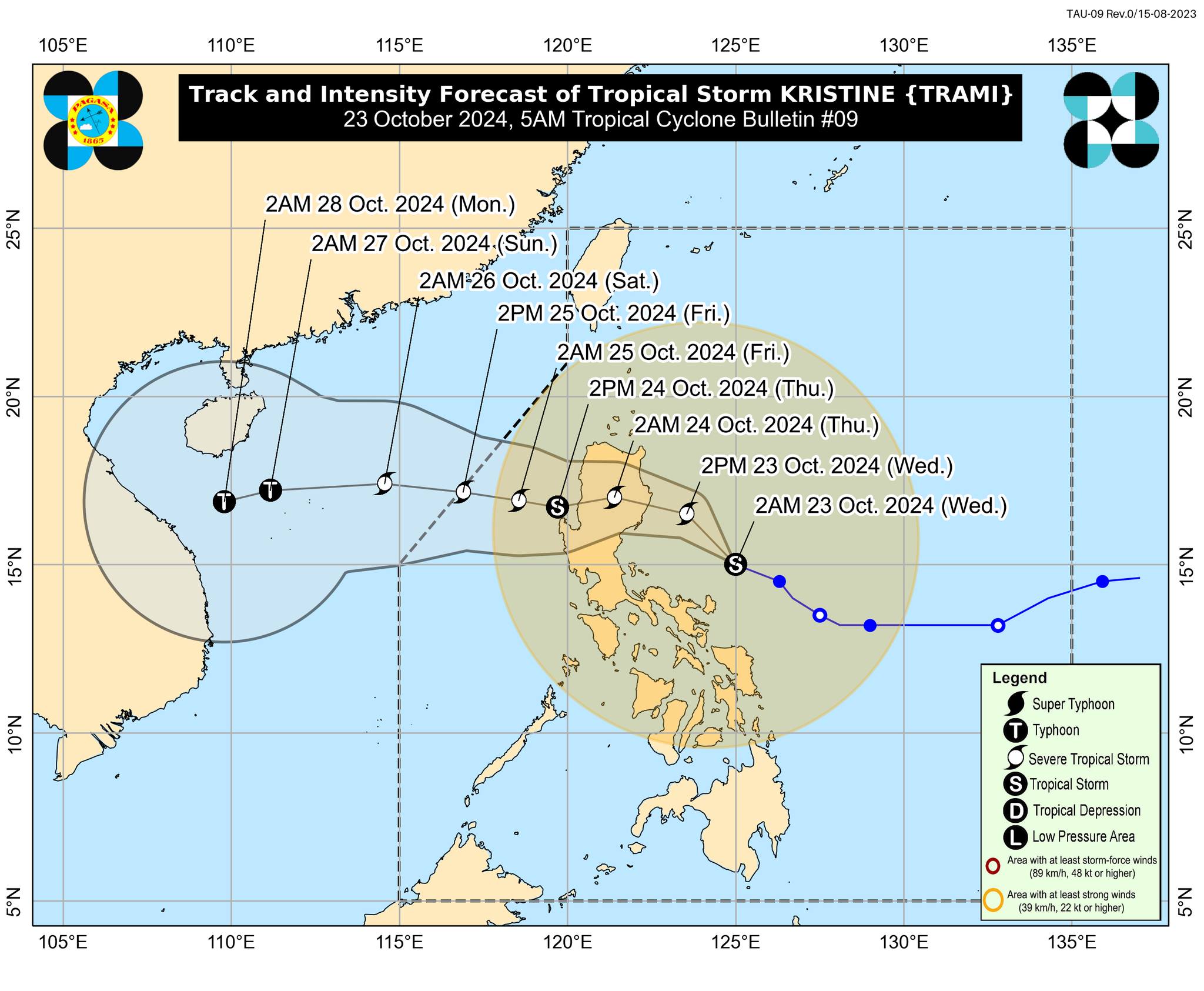
Tropical storm Kristine is forecast to move northwestward over the next 24 hours, before shifting westward. It is expected to make landfall over Isabela or northern Aurora either Wednesday evening or Thursday morning, according to state meteorologists. (Track forecast courtesy of DOST / Pagasa)
MANILA, Philippines — A total of 26 areas have been placed under Tropical Cyclone Wind Signal (TCWS) No. 2 on Wednesday morning as tropical storm Kristine (international name: Trami) gets closer to Philippine landmass.
,In a 5 a.m. bulletin, the Philippine Atmospheric, Geophysical, and Astronomical Services Administration (Pagasa) said Kristine was last spotted some 180 kilometers (km) north northeast of Virac, Catanduanes.
It is packing maximum sustained winds of 85 kilometers per hour (kph) near the center, with gusts of up to 105 kph.
Kristine is moving northwestward at 25 kph.
“Kristine is forecast to move generally northwestward for the next 24 hours before turning generally westward for the rest of the forecast period,” Pagasa said.
“It is forecast to make landfall over Isabela or northern Aurora this evening (October 23) or tomorrow (October 24) early morning,” it noted.
The tropical storm may exit the Philippine area of responsibility on Friday.
The following 26 areas across the country are currently under TCWS No. 2, where winds exceeding 62 kph, but not exceeding 88 kph, are expected within the next 24 hours:
Luzon
Ilocos Norte
Ilocos Sur
La Union
Pangasinan
Apayao
Abra
Kalinga
Mountain Province
Ifugao
Benguet
Mainland Cagayan
Isabela
Quirino
Nueva Vizcaya
Aurora
Nueva Ecija
Tarlac
Northern portion of Zambales (Santa Cruz, Candelaria, Masinloc, Palauig), the northern portion of Bulacan (Doña Remedios Trinidad, San Miguel, San Ildefonso)
Northern portion of Quezon (General Nakar, Infanta) including Polillo IslandsCamarines Norte
Northern and eastern portions of Camarines Sur (Calabanga, Goa, Tigaon, Saglay, San Jose, Lagonoy, Tinambac, Siruma, Garchitorena, Presentacion, Caramoan)
Catanduanes
Eastern portion of Albay (Rapu-Rapu, Bacacay, City of Tabaco, Malilipot, Malinao, Tiwi, Manito, Santo Domingo)
Eastern portion of Sorsogon (Barcelona, Gubat, Prieto Diaz, City of Sorsogon)
Visayas
Northeastern portion of Northern Samar (Palapag, Mapanas, Gamay, Laoang, Catubig, Lapinig, Pambujan, San Roque)
Northern portion of Eastern Samar (Jipapad, San Policarpo, Arteche)
“Minor to moderate impacts from gale-force winds are possible within any of the localities where Wind Signal No. 2 is hoisted,” according to Pagasa.
Meanwhile, the following areas are under TCWS No. 1, where wind speeds ranging from 39 to 61 kph are expected:
Luzon
Batanes
Babuyan Islands
Pampanga
The rest of Zambales
Bataan
The rest of Bulacan
Metro Manila
Rizal
Cavite
Laguna
Batangas
The rest of Quezon
Occidental Mindoro including Lubang Islands
Oriental Mindoro
Marinduque
Romblon
Calamian Islands
The rest of Camarines Sur
The rest of Albay
The rest of Sorsogon
Masbate including Ticao and Burias Islands
Calamian Islands
Visayas
Aklan
Capiz
Antique including Caluya Islands
Iloilo
Guinaras
Northern portion of Negros Occidental (Pontevedra, La Castellana, Moises Padilla, Bago City, La Carlota City, Valladolid, Pulupandan, Bacolod City, San Enrique, Murcia, Silay City, City of Talisay, Enrique B. Magalona, Manapla, City of Victorias, Cadiz City, Sagay City, City of Escalante, Toboso, Calatrava, Salvador Benedicto, San Carlos City)
Northern portion of Negros Oriental (Vallehermoso, Canlaon City, City of Guihulngan)
Northern and central portions of Cebu (Alcantara, Argao, Dumanjug, Sibonga, Pinamungahan, Ronda, Liloan, Cebu City, Moalboal, Consolacion, Danao City, Borbon, Carmen, Daanbantayan, Tuburan, City of Bogo, Tabogon, City of Naga, Lapu-Lapu City, City of Carcar, Mandaue City, Catmon, Minglanilla, Toledo City, Cordova, Compostela, San Remigio, Balamban, Aloguinsan, San Fernando, Asturias, Barili, Medellin, Sogod, Tabuelan, City of Talisay) including Bantayan Islands and Camotes Islands
Bohol
The rest of Eastern Samar
The rest of Northern Samar
Samar
Leyte
Biliran
Southern Leyte
Mindanao
Dinagat Islands
Surigao del Norte including Siargao – Bucas Grande Group
Pagasa noted that areas under TCWS No. 1 may experience minimal to minor impacts from strong winds.
As of 5 a.m., a gale warning is hoisted over the seaboards of Luzon and Visayas.
READ: Kristine puts 11 areas under WS No. 2, landfalls in Isabela or Aurora