Kristine puts 11 areas under WS No. 2, landfalls in Isabela or Aurora
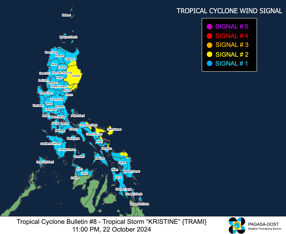
MANILA, Philippines — Tropical Storm Kristine on Tuesday put 11 areas under Wind Signal No. 2 as it poised to make landfall either in Isabela or Aurora, state meteorologists said.
As of 11 p.m., Kristine was last spotted 345 kilometers east northeast of Daet, Camarines Norte, moving northwestward as it packs maximum sustained winds of 75 kilometers per hour (km/h) near the center with gustiness of up to 90 km/h, according to the Philippine Atmospheric, Geophysical and Astronomical Services Administration’s (Pagasa).
“It is forecast to make landfall over Isabela or northern Aurora tomorrow evening or on Thursday (24 October) early morning,” Pagasa said in its forecast.
READ: Kristine can strengthen into super typhoon, says Pagasa
“It will then cross the mountainous terrain of Northern Luzon and emerge over the waters west of Ilocos Region on Thursday afternoon or evening,” it added.
These 11 areas in Luzon and Visayas are under Tropical Storm Wind Signal No. 2, where winds of greater than 62 km/h and up to 88 km/h may be expected in at least 24 hours, causing minor to moderate impacts to life and property:
Luzon
- Cagayan (Peñablanca, Enrile, Tuguegarao City)
- Isabela
- Northeastern portion of Quirino (Maddela)
- Northeastern portion of Aurora (Dinalungan, Casiguran, Dilasag)
- Catanduanes
- Eastern portion of Camarines Norte (Basud, Daet, Talisay, Vinzons, Paracale, Mercedes)
- Eastern portion of Camarines Sur (Caramoan, Presentacion, Garchitorena, Tinambac, Siruma, Lagonoy, Goa, San Jose, Saglay, Tigaon)
- Eastern portion of Albay (Rapu-Rapu, Bacacay, City of Tabaco, Malilipot, Malinao, Tiwi)
- Eastern portion of Sorsogon (Barcelona, Gubat, Prieto Diaz)
Visayas
- Northeastern portion of Northern Samar (Palapag, Mapanas, Gamay, Laoang, Catubig, Lapinig, Pambujan, San Roque)
- Northern portion of Eastern Samar (Jipapad, San Policarpo, Arteche)
Also, most areas in Luzon as well as parts of Visayas, and Mindanao are under TCWS No. 1, causing 39 to 61 km/h wind speed, which may lead to minimal to minor threat to life and property:
Luzon
- Ilocos Norte
- Ilocos Sur
- La Union
- Pangasinan
- Apayao
- Kalinga
- Abra
- Mountain Province
- Ifugao
- Benguet
- Batanes
- The rest of Cagayan including Babuyan Islands
- The rest of Quirino
- Nueva Vizcaya
- The rest of Aurora
- Nueva Ecija
- Tarlac
- Zambales
- Bataan
- Pampanga
- Bulacan
- Metro Manila
- Cavite
- Laguna
- Batangas
- Rizal
- Quezon including Pollilo Islands
- Occidental Mindoro including Lubang Islands
- Oriental Mindoro
- Masbate including Ticao and Burias Islands
- Marinduque
- Romblon
- The rest of Camarines Norte
- The rest of Camarines Sur
- The rest of Albay
- The rest of Sorsogon
- Calamian Islands
Visayas
- Aklan
- Capiz
- The northern portion of Antique (Libertad, Pandan, Sebaste, Culasi) including Caluya Islands
- The northern portion of Iloilo (Sara, Batad, San Dionisio, Carles, Estancia, Balasan)
- The rest of Eastern Samar
- The rest of Northern Samar
- Samar
- Leyte
- Biliran
- Southern Leyte
Mindanao
- Dinagat Islands
- Surigao del Norte including Siargao-Bucas Grande Group