LPA inside PAR turns into Tropical Depression Julian
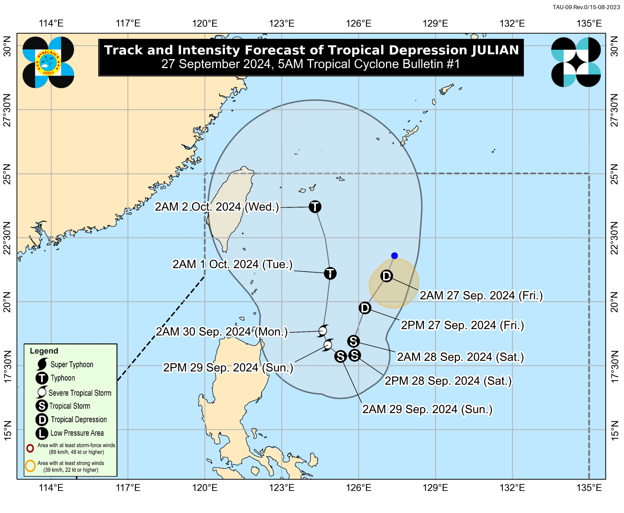
Forecast track of Tropical Depression Julian. Photo from Pagasa
MANILA, Philippines — A low-pressure area (LPA) spotted inside the Philippine area of responsibility (PAR) developed into a tropical depression named Julian on Friday morning, the Philippine Atmospheric, Geophysical and Astronomical Services Administration (Pagasa) said.
In the coming days, Julian will likely become a strong typhoon, the state weather agency added.
Based on Pagasa’s early morning report, the center of Julian was located 525 kilometers east of Itbayat, Batanes, as of 4:00 a.m. It was packing maximum sustained winds of 55 kilometers per hour (kph) near the center and gustiness of up to 70 kph.
As of posting, Pagasa has yet to raise a Tropical Cyclone Wind Signal (TCWS) over any part of the country.
Article continues after this advertisementHowever, Julian – the 10th tropical cyclone to affect the country this year and the sixth in September – is expected to place Cagayan Valley under TCWS No. 1 later Friday. Pagasa said the region may also see itself placed under a higher TCWS while Julian lingers.
Article continues after this advertisementAccording to Pagasa, Julian is “forecast to follow a looping path over the waters east of Batanes and Cagayan in the next five days.”
“Initially, the tropical cyclone will head south southwestward today while decelerating, then move slowly westward tomorrow (28 September) and northwestward on Sunday (29 September), before accelerating generally northward on Monday (30 September) and Tuesday (01 October),” Pagasa explained.
READ: Pagasa: LPA may form inside PAR and become a storm by weekend
Julian may become a tropical storm later Friday or by Saturday morning before developing into a severe tropical storm and typhoon by Sunday and Tuesday, respectively, the state meteorologist noted.
“The tropical depression will continuously intensify throughout the forecast period,” Pagasa likewise said.
READ: LPA outside PAR now a tropical depression, says Pagasa
Meanwhile, two weather disturbances outside PAR – a tropical depression near Guam, and another LPA near the PAR’s boundary – are also currently being monitored by the state weather agency.
“But none of them will enter the PAR and [they] would not affect any parts of our country,” said Pagasa weather specialist Benison Estareja during a public weather report on Friday morning.