Carina halts air, sea trips in parts of Luzon

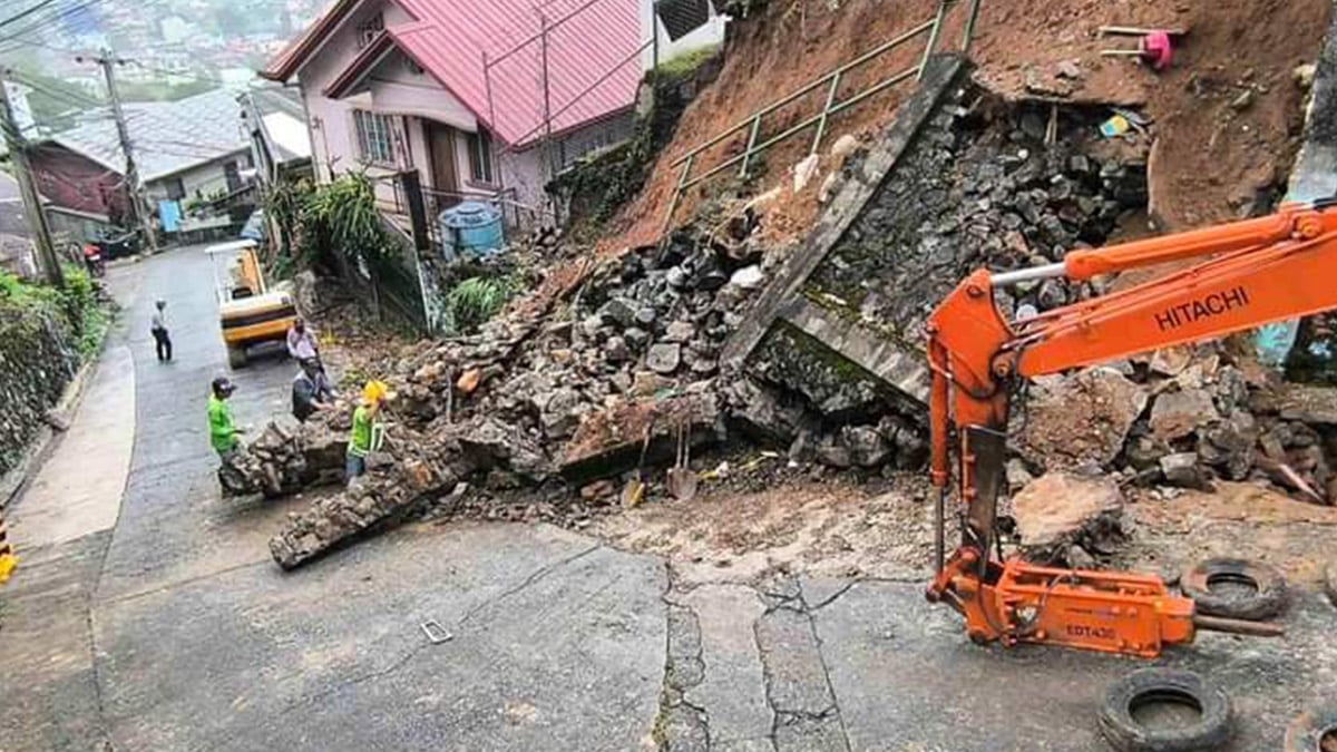
DAMAGED PROTECTION Emergency responders in Baguio City start clearing on Monday afternoon the eroded riprap in Barangay Gabriela Silang following strong rains dumped by Typhoon “Carina.” —Baguio Public Information Office photo
BASCO, BATANES, Philippines — Air and sea travel across some parts of northern and southern Luzon were suspended on Monday amid bad weather spawned by Typhoon Carina (international name: Gaemi).
The province of Batanes and parts of Cagayan and Isabela provinces were placed under Tropical Cyclone Wind Signal No. 1 on Monday due to the heavy rainfall and strong winds caused by the weather disturbance.
Carina, which earlier on Monday was categorized as a severe tropical depression, intensified into a typhoon as it was “meandering over the Philippine Sea,” according to the 5 p.m. bulletin of the Philippine Atmospheric, Geophysical and Astronomical Services Administration (Pagasa).
READ: ‘Habagat’ displaces more than 600,000 even as ‘Carina’ stays offshore
Signal No. 1 was hoisted over the eastern portion of mainland Cagayan (Santa Ana, Gattaran, Baggao, Peñablanca, Lal-Lo, Gonzaga), including the eastern portion of Babuyan Islands (Camiguin Island, Babuyan Islands).
Article continues after this advertisementAlso under Signal No. 1 was the northeastern portion of Isabela (Divilacan, Palanan, Maconacon).
Article continues after this advertisementPagasa said these areas experienced winds ranging from 39 to 61 kilometers per hour (kph) in at least 36 hours or intermittent rains.
Canceled flights
The storm forced the cancellation of some domestic flights, including those of Philippine Airlines Express, Cebu Pacific, and CebGo to and from Basco in Batanes, Tuguegarao City, and Cagayan, according to the Manila International Airport Authority.
Roldan Esdicul, chief of the Batanes Provincial Disaster Risk Reduction and Management Office (PDRRMO), said Skypasada flights to Tuguegarao had also been canceled on Monday.
He said boat trips to and from Itbayat had been suspended indefinitely due to the rough seas.
In Bataan province, village officials in Orani town said only a few fishermen went out to fish within the municipal waters for fear that strong waves would destroy their motorboats.
Floodwaters also seeped into houses in Orani’s coastal villages of Pantalan Luma and Wawa. Fishermen there refrained from going out to fish due to the heavy rains and powerful waves.
Swamped rice fields
In Samal town, also in Bataan, floods damaged newly planted palay (rice plants) due to the heavy downpour. Houses there were also not spared by rushing floodwater from nearby rice fields.
In Bataan’s Dinalupihan town, rice and other agricultural crops were partially damaged by floodwaters, the damage cost of which has yet to be reported by the local agriculture office.
The Bataan PDRRMO has yet to release reports on the damage and status of flooded areas in Bataan.
In Olongapo City, strong winds toppled electric posts while heavy rains threatened to spawn flooding in its low-lying areas.
According to the city’s DRRMO, around 7.5 to 15 millimeters of rainfall were observed in Olongapo.
In Pampanga province, the PDRRMO operations center and command and control center have been placed under Alpha Protocol or at low-risk due to Carina, according to PDRRMO head Angelina Blanco.
The PDRRMO had prepositioned equipment and placed personnel on standby around the clock, said Blanco in a 1:30 p.m. report on Monday.
Local DRRMOs in Pampanga were also monitoring the situations in 19 towns and cities, especially coastal areas along the Pampanga River, the main drain of Central Luzon to Manila Bay.
In Baguio City, the incessant rains caused soil erosion in Barangay Gabriela Silang, damaging the rock riprap near a residential area but no one was reported injured.
Baguio Mayor Benjamin Magalong asked residents to prepare for “abnormally heavy rainfall” due to the enhanced monsoon rains as he cautioned the public against indiscriminately throwing garbage to prevent this from ending up into drain outlets that could cause widespread flooding.
Swollen rivers
In Albay, Gov. Edcel Greco Lagman suspended all outdoor and water activities on Monday due to heavy rains and the effects of the southwest monsoon.
Lagman advised the public to avoid crossing the river and low-lying areas due to expected river swelling and flooding. Fishermen using small seacrafts were also asked to avoid venturing into the sea.
According to the governor, all local officials could implement localized evacuations if needed, especially in areas that are prone to lahar, floods, and landslides.
The Pagasa Southern Luzon issued a yellow rainfall warning in Albay at 11 a.m. due to heavy rains that could trigger flooding in low-lying areas.
Moderate rains were also expected in the provinces of Camarines Norte, Camarines Sur, Sorsogon, Catanduanes, Masbate and Marinduque.
The Philippine Coast Guard (PCG) suspended sea travel for small vessels in the northern part of Quezon province due to rough sea conditions on Monday.
In an advisory, the PCG in Quezon cited the 8 a.m. forecast by Pagasa that moderate to rough seas are expected to affect the eastern seaboards of northern Quezon, particularly in Patnanungan and Jomalig Islands, due to the southwest monsoon enhanced by Carina.
This meant that all trips by vessels with a gross tonnage of 250 or less, like motorized passenger or fishing boats in the northern Quezon part of the Pacific Ocean, were suspended.
The suspension order would be lifted, and sea travel for small seacraft may be resumed when weather or sea conditions permit, as may be declared by Pagasa, the PCG said.
Carina was last tracked 420 km east of Tuguegarao City, Cagayan, slowly moving north northwestward. It packed a maximum sustained winds of 120 km/h near the center and gustiness of up to 150 km/h.