Kabayan weakens as it reaches Agusan del Sur Monday afternoon
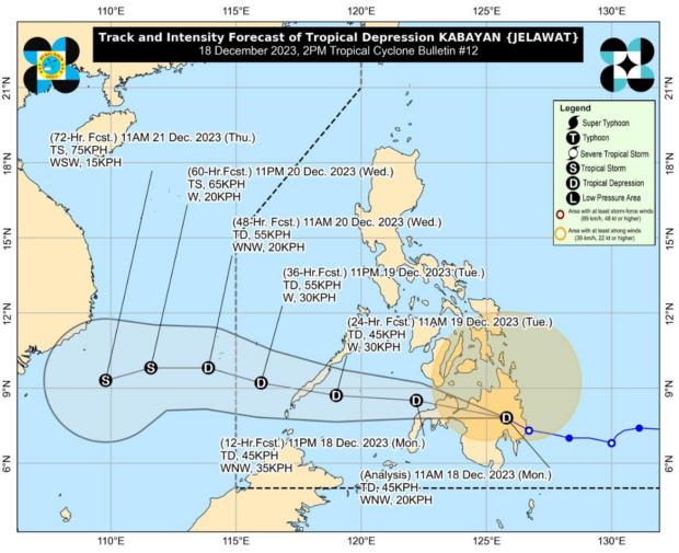
Image from DOST / Pagasa
MANILA, Philippines — Tropical Depression Kabayan (international name Jelawat) has further weakened as it accelerated west northwestward across southern Philippines, the Philippine Atmospheric, Geophysical and Astronomical Services Administration (Pagasa) said on Monday afternoon.
In a 2 p.m. cyclone update, state meteorologists reported that Kabayan was last spotted in the vicinity of Loreto, Agusan del Sur with maximum sustained winds of 45 kilometers per hour (kph) and gustiness of up to 75 kph while moving at the speed of 20 kph.
In an earlier update, Pagasa said that Kabayan made landfall in Manay, Davao Oriental around 9:30 a.m.
Following this development, Tropical Cyclone Wind Signal Number 1 is still hoisted in two areas in Luzon and 25 provinces in Visayas and Mindanao.
READ: Kabayan makes landfall in Davao Oriental, weakens into tropical depression
Article continues after this advertisementSignal Number 1 suggests that there is a possibility of minimal to minor impacts from strong winds, according to Pagasa.
Article continues after this advertisementThe weather bureau also issued heavy rainfall warnings in some areas in Mindanao:
Red Rainfall Warning:
- Davao Oriental
Orange Rainfall Warning:
- Bukidnon
- Agusan del Norte
According to Pagasa, a Red Rainfall Warning is issued in areas where there could be rainfall exceeding 30 millimeters (mm) within one hour or if there has been continuous rainfall for the past three hours and has already reached more than 65 mm.
Meanwhile, an Orange Rainfall Warning is issued when the observed rainfall is between 15 mm and 30 mm within one hour. This indicates a definite risk of flooding in communities placed under the orange alert.
Meanwhile, a gale warning is still in effect for the coastal waters along:
- The seaboards of Northern Luzon
- The eastern and central seaboards of Visayas
- The eastern seaboards of Central Luzon
- The seasboards of Southern Luzon
- The seaboards of Mindanao
Kabayan will continue to track generally westward or west northwestward across the country in the next two days, Pagasa said.
State meteorologists expect the tropical depression to further weaken into a low pressure area in the coming days as it crosses Mindanao.
READ: Heavy rainfall alerts up in 11 areas in Visayas, Mindanao – Pagasa
This is due to the frictional effects associated with landfall, the weather bureau said.
However, Kabayan is forecast to make another landfall over central or southern Palawan as a tropical depression on Tuesday morning or afternoon.