Know the latest on Tropical Storm Kabayan through our LIVE UPDATES
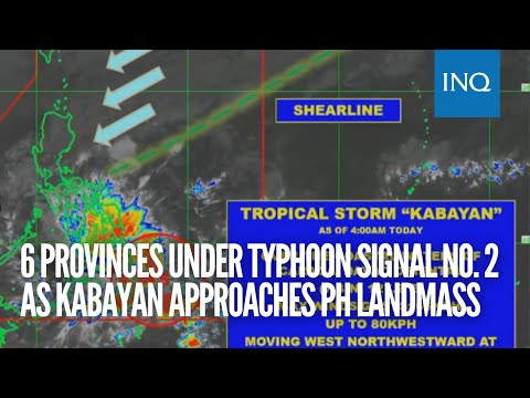
MANILA, Philippines — Six provinces in Mindanao are under Tropical Cyclone Wind Signal Number 2.
Strormy conditions will prevail in several regions as Tropical Storm ‘Kabayan‘ continues to move closer to land on Monday morning, December 18, 2023.
In its 5 a.m. bulletin, the Philippine Atmospheric, Geophysical and Astronomical Services Administration (Pagasa) said Kabayan (international name Jelawat) was last seen over the coastal waters of Caraga, Davao Oriental.
Kabayan is carrying maximum sustained winds of up to 65 kilometers per hour (kph) and a gustiness of up to 80 kph.
It is moving west northwestward at 15 kph.
The weather bureau predicts Kabayan will make landfall along the coast of Davao Oriental or southern Surigao del Sur on Monday morning.
In an early morning press briefing, weather specialist Grace Castañeda said Kabayan is already bringing heavy rainfall and strong winds to the eastern portion of Mindanao.
Besides the tropical storm, two weather systems are also spawning rains over the country on Monday, Castañeda noted.
The northeast monsoon, locally known as amihan, is still affecting northern and Central Luzon where it will bring overcast skies and some rainfall.
A shear line, or the convergence of warm and cold winds, is forecast to dump rains in the eastern section of Southern Luzon particularly along Bicol region.
“Under the influence of the northeast monsoon surge and Tropical Storm Kabayan, a gale warning is in effect for the coastal waters along the seaboard of Northern Luzon, the eastern and central seaboards of Visayas, and the eastern seaboards of Central Luzon, Southern Luzon, and Mindanao,” Pagasa said.
The tropical storm will likely cross the rugged terrain of Mindanao and emerge over Sulu Sea between Monday afternoon and evening.
Kabayan intensified into a tropical storm on Sunday evening.
Signal Number 2 is hoisted in the following areas:
Mindanao
Dinagat Islands
Surigao del Norte including Siargao and Bucas Grande Islands
Surigao del Sur
Northern portion of Agusan del Norte (Kitcharao, Jabonga, Santiago, city of Cabadbaran, Remedios T. Romualdez, Tubay)
Eastern portion of Agusan del Sur (Trento, Bunawan, San Francisco, Rosario, Prosperidad, city of Bayugan, Sibagat)
Northern portion of Davao Oriental (Boston, Cateel)
Meanwhile, Signal Number 1 is in effect in the following areas:
Visayas
Southern Leyte
Leyte
Southern portion of Samar (Basey, Santa Rita, Marabut, Talalora, Villareal, Pinabacdao)
Southern portion of Eastern Samar (Maydolong, city of Borongan, Quinapondan, Guiuan, Lawaan, Balangiga, Llorente, Giporlos, Salcedo, Balangkayan, General Macarthur, Hernani, Mercedes)
Cebu including Camotes and Bantayan Islands
Bohol
Siquijor
Negros Oriental
Negros Occidental
Mindanao
Rest of Agusan del Norte
Rest of Agusan del Sur
Central portion of Davao Oriental (Baganga, Manay, Caraga)
Davao de Oro
Davao del Norte
Davao city
Camiguin
Misamis Oriental
Misamis Occidental
Lanao del Norte
Lanao del Sur
Northern portion of Maguindanao del Norte (Buldon, Barira, Matanog)
Northern portion of Cotabato (Arakan, Carmen, Banisilan, Alamada, President Roxas, Kabacan, Matalam, Antipas, Magpet)
Northern portion of Zamboanga del Sur (Midsalip, Labangan, Tukuran, Aurora, Sominot, Ramon Magsaysay, Tambulig, Dumingag, Mahayag, Josefina, Molave)
Northeastern portion of Zamboanga del Norte (Siayan, Sindangan, Jose Dalman, Manukan, Pres. Manuel A. Roxas, Sergio Osmeña Sr., Katipunan, Dipolog City, Polanco, Mutia, Piñan, Dapitan city, Sibutad, La Libertad, Rizal)
Signal Number 2 indicates there may be minor to moderate impacts from gale force winds in the affected areas.
Signal Number 1 means there is a possibility of minimal to minor impacts from strong winds.
