Pagasa: Jenny now a severe tropical storm

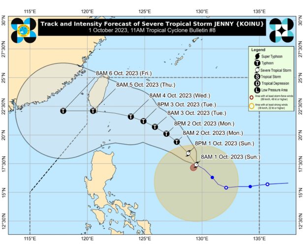
Track of Severe Tropical Storm Jenny (international name: Koinu). Photo from Pagasa
MANILA, Philippines — Jenny (international name: Koinu) has turned into a Severe Tropical Storm as it moved west-northwestward over the Philippine Sea, the Philippine Atmospheric, Geophysical and Astronomical Services Administration (Pagasa) said.
In its 11 a.m. weather bulletin, the state weather agency said the center of Jenny was located 790 kilometers east of Tuguegarao City, Cagayan, as it carried maximum sustained winds of 95 kilometers per hour (kph) and gustiness of up to 115 kph at a speed of 15 kph.
Pagasa said wind signals may be raised over extreme northern Luzon by Sunday afternoon or evening, in consideration of the anticipated windy conditions that may be triggered by Jenny.

READ: Tropical Storm Jenny further intensifies, may become typhoon
Jenny is also forecast to bring light to moderate rains on Sunday until Monday afternoon in mainland Cagayan, Isabela, and Quezon including Polillo Islands, Camarines Norte, Camarines Sur, Catanduanes, Albay, Sorsogon, Northern Samar, and Eastern Samar.
It is likewise predicted to enhance the southwest monsoon, locally known as habagat, in the next three days, according to Pagasa, and cause occasional to steady rains over the western portions of Central and Southern Luzon, Visayas, and Mindanao.
READ: Pagasa: Tropical Storm Jenny slightly slows down
Based on the latest models of the state weather bureau, Jenny may pass between Batanes and the southern portion of Taiwan by Wednesday evening (October 4) and that “a landfall or close approach scenario over extreme northern Luzon is still not ruled.”
“Jenny is forecast to intensify throughout the forecast period steadily and may reach typhoon category tomorrow (October 2). This tropical cyclone could attain its peak intensity of 150 kph by Tuesday (October 3),” Pagasa added.