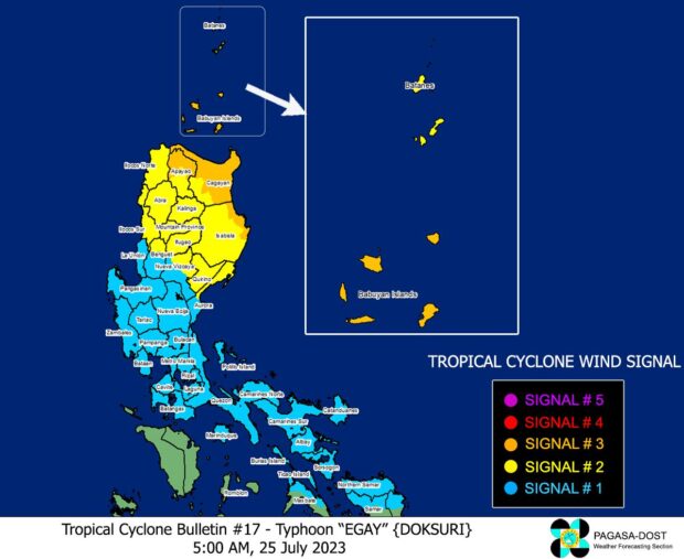
MANILA, Philippines — Three areas are hoisted under Tropical Cyclone Wind Signal (TCWS) No. 3 as Typhoon Egay (international name Doksuri) is seen to reach super typhoon category on Tuesday, the Philippine Atmospheric, Geophysical and Astronomical Services Administration (Pagasa) said in its latest update.
These areas are under TCWS No. 3, where winds greater than 89 kilometers per hour (kph) to up to 117 kph could be expected in at least 18 hours:
- Babuyan Islands
- the northern and eastern portions of mainland Cagayan (Santa Ana, Gonzaga, Peñablanca, Gattaran, Lal-Lo, Alcala, Santa Teresita, Buguey, Aparri, Camalaniugan, Ballesteros, Allacapan, Abulug, Claveria, Pamplona, Sanchez-Mira, Santa Praxedes, Lasam, Baggao, Amulung, Iguig), the northeastern portion of Isabela (Divilacan, Maconacon, Palanan)
- the northern portion of Apayao (Calanasan, Luna, Santa Marcela, Flora, Pudtol)
Meanwhile, 13 areas were placed under TCWS No. 2, where winds of greater than 62 kilometers per hour (kph) and up to 88 kph may be expected in at least 24 hours:
- Batanes
- the rest of mainland Cagayan
- the rest of Isabela, Quirino
- the northern portion of Nueva Vizcaya (Kasibu, Quezon, Diadi, Bagabag, Ambaguio, Villaverde, Solano, Bayombong)
- the rest of Apayao
- Kalinga
- Abra
- Mountain Province
- Ifugao
- the northern portion of Benguet (Bakun, Mankayan, Buguias, Kabayan, Kibungan)
- Ilocos Norte
- Ilocos Sur
- the northern and central portion of Aurora (Dilasag, Casiguran, Dinalungan, Dipaculao)
Also, these 27 areas are under TCWS No. 1, where winds of 39-61 kph or intermittent rains may be expected within 36 hours:
Luzon
- La Union
- Pangasinan
- the rest of Benguet
- the rest of Nueva Vizcaya
- the rest of Aurora
- Zambales
- Bataan
- Nueva Ecija
- Tarlac
- Pampanga
- Bulacan
- Metro Manila
- Rizal
- Laguna
- Cavite
- Batangas
- Quezon
- Marinduque
- Camarines Norte
- Camarines Sur
- Catanduanes
- Albay
- Sorsogon
- the northern portion of Masbate (Uson, Dimasalang, City of Masbate, Mobo, Palanas, Aroroy, Baleno) including Burias and Ticao Islands
Visayas
- Northern Samar
- the northern portion of Samar (San Jose de Buan, Matuguinao, Gandara, Santa Margarita, Calbayog City)
- Northern portion of Eastern Samar (Oras, Arteche, Jipapad, Dolores, San Policarpo, Maslog)
Egay’s center is located 350 kilometers east of Tuguegarao City, Cagayan, packing maximum sustained winds of 175 kph near the center and gustiness of up to 215 kph, according to Pagasa.
Pagasa said this typhoon will become a super typhoon on Tuesday and is seen to make landfall or pass very close to Babuyan Islands-northeastern mainland Cagayan area.
“On the track forecast, this typhoon is forecast to make landfall or pass very close to Babuyan Islands-northeastern mainland Cagayan area between late evening today and tomorrow afternoon,” Pagasa said.
“Egay is forecast to continue intensifying and reach super typhoon category within 12 hours, although the window of intensification for this typhoon is closing,” it added.
After this, Egay is seen to weaken, according to Pagasa.
“A weakening trend may begin as the typhoon passes over the Babuyan Islands due to the potential onset of eyewall replacement cycle and interaction with the rugged terrain of Northern Luzon,” the state weather bureau said.
“Further weakening is expected outside the PAR region due to increasingly unfavorable environment and the eventual landfall over the landmass of China,” it added.
