
MANILA, Philippines – Tropical Storm Paeng (international name: Nalgae) is now over the West Philippine Sea after leaving a trail of destruction across Luzon, Visayas and Mindanao over the weekend, according to the state weather bureau.
In its early Sunday morning update, the Philippine Atmospheric, Geophysical and Astronomical Services Administration (Pagasa) reported that moderate to heavy rainfall is still possible in Zambales, Bataan, Aurora, Pangasinan, Batanes, and the northern portion of Cagayan including Babuyan Islands.
Light to moderate and at times heavy rain, Pagasa added, is possible in Metro Manila, Cordillera Administrative Region, Cazlabarzon (Cavite, Laguna, Batangas, Rizal, Quezon) Mimaropa (Mindoro, Marinduque, Romblon, Palawan)
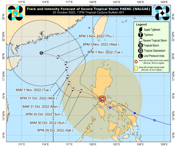
Tracking Paeng
Paeng was last spotted 85 kilometers west-northwest of Iba, Zambales, packing maximum sustained winds of 85 kilometers per hour (kph) near the center and gustiness of up to 105 kph and moving west-northwest at 30 kph.
Paeng is forecast to exit the Philippine area of responsibility by Monday morning or afternoon.
Wet, windy weekend
Tropical Cyclone Wind Signal (TCWS)Number 2 is up over nine areas in Northern and Central Luzon and Signal Number 1 is up over 29 other nareas, including Metro Manila.
“Winds reaching gale-force strength may still be experienced any of the areas where Wind Signal No. 2 is in effect. Areas under Wind Signal No.1 may experience strong winds (strong breeze to near gale strength) throughout the passage of the tropical cyclone,” Pagasa said in its latest update.
TCWS No. 2 is up over the following areas / provinces:
- Luzon
- Pangasinan
- La Union
- southern portion of Ilocos Sur (City of Candon, Banayoyo, Galimuyod, Sigay, Suyo, Santa Lucia, Santa Cruz, Alilem, Tagudin, Sugpon, Cervantes, Quirino, Gregorio del Pilar, Salcedo, Lidlidda, San Emilio, Santiago, Burgos, Santa Maria, San Esteban)
- Benguet
- Tarlac
- Zambales
- ‘western portion of Bataan (Morong, Bagac, Dinalupihan, Hermosa)
- western portion of Pampanga (Floridablanca, Mabalacat City, Magalang, Angeles City, Porac)
- northwestern portion of Nueva Ecija (Guimba, Cuyapo, Talugtug, Nampicuan)
TCWS No. 1 is up over the following areas / provinces:
- Luzon
- Cagayan including Babuyan Islands
- Isabela
- Quirino
- Nueva Vizcaya
Apayao - Kalinga
Ifugao - Mountain Province
- Abra
- Ilocos Norte
- rest of Ilocos Sur
- Aurora
- rest of Nueva Ecija
- rest of Pampanga
- Bulacan
- rest of Bataan
- Metro Manila
- Laguna
- Rizal
- Batangas
- Cavite
- Quezon including Pollilo Islands
- Marinduque
- northwestern portion of Romblon (Concepcion, Banton, Corcuera)
- Occidental Mindoro including Lubang Islands
- Oriental Mindoro
- Calamian Islands
- Camarines Norte
- northwestern portion of Camarines Sur (Lupi, Ragay, Del Gallego, Sipocot)
gsg