Paeng cuts through Metro Manila, Rizal, Bulacan
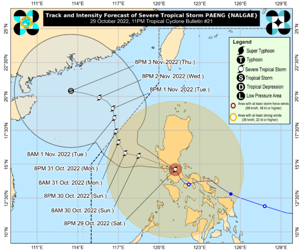
MANILA, Philippines — Severe Tropical Storm Paeng, internationally known as Nalgae, cut through Metro Manila, Rizal, and Bulacan as it headed out of the Luzon landmass on Sunday, according to the Philippines Atmospheric, Geophysical and Astronomical Services Administration (Pagasa) said in its 11 p.m. bulletin on Saturday.
Pagasa said that Paeng may exit the Luzon landmass Sunday morning at the earliest, moving northwest and exiting the Philippine Area of Responsibility six to 12 hours later.
“Afterwards, Paeng will track north-northwestward over the West Philippine Sea until Tuesday. On the track forecast, this tropical cyclone may exit the Philippine Area of Responsibility on Monday,” Pagasa said.
The center of Paeng was last spotted in the vicinity of Baliuag, Bulacan, with maximum sustained winds of 95 kph near the center with gustiness of up to 160 kph.
Meanwhile, fewer areas in the country remained under Tropical Wind Signal No. 3.
Article continues after this advertisementFollowing are the areas under Signal No. 3, which will have storm-force winds that could pose a moderate to a significant threat to life and property.
Article continues after this advertisement- the northern portion of Metro Manila: Manila, Valenzuela, Malabon, Navotas, Caloocan, and Quezon City
- Bataan
- the southern portion of Zambales: San Marcelino, Subic, Olongapo City, Castillejos, San Antonio, San Narciso, San Felipe, Cabangan, Botolan, Palauig, and Iba
- Pampanga
- Bulacan
- the southern portion of Tarlac: Concepcion, Capas, San Jose, and Bamban
Following are the areas under Signal No. 2, which will experience gale-force winds that could pose a minor to moderate threat to life and property.
- Pangasinan
- the southern portion of Aurora: San Luis, Baler, Dingalan, and Maria Aurora
- the rest of Tarlac
- Nueva Ecija
- the rest of Zambales
- Laguna
- Batangas
- the northern and central portions of Quezon: Alabat, Perez, Plaridel, Atimonan, Unisan, Agdangan, Padre Burgos, Pagbilao, Sariaya, Lucena, San Antonio, Tiaong, Candelaria, Dolores, Tayabas, Lucban, Sampaloc, Mauban, General Nakar, Infanta, and Real including Pollilo Islands
- Rizal
- Cavite
- the rest of Metro Manila
- Cavite
- the northern portion of Oriental Mindoro: Victoria, Naujan, San Teodoro, Baco, Puerto Galera, and Calapan
- The northern portion of Occidental Mindoro: Santa Cruz, Abra de Ilog, Mamburao, and Paluan including Lubang Islands
Following are the areas under Signal No. 1, where strong winds may cause minimal to minor destruction to life and property:
Luzon
- La Union
- Kalinga
- Abra
- Benguet
- Ifugao
- Ilocos Sur
- Mountain Province
- Nueva Vizcaya
- Quirino
- Isabela
- the rest of Aurora
- the rest of Quezon
- Catanduanes
- Camarines Sur
- Camarines Norte
- Albay
- Sorsogon
- the western portion of Masbate: Milagros, Mobo, Uson, City of Masbate, Aroroy, Balud, Mandaon, and Baleno including Burias and Ticao Islands
- the rest of Occidental Mindoro
- the rest of Oriental Mindoro
- Palawan: El Nido and Taytay including Calamian Islands, Cuyo Islands
- Romblon
- Marinduque
Visayas
- Capiz
- Aklan
- the northern portion of Antique: Barbaza, Culasi, Tibiao, Sebaste, Libertad, Bugasong, Laua-An, and Pandan including Caluya Islands
RELATED STORIES
Bongbong Marcos urged: Declare national state of calamity due to Paeng
Albay placed under state of calamity due to Paeng
6,285 families in Negros Occidental affected by floods triggered by Paeng
