
Tropical Depression Neneng slightly intensified on Friday, now packing maximum sustained winds of 55 kilometers per hour.
MANILA, Philippines — Tropical Depression Neneng slightly intensified as it moved closer to the country’s landmass, the Philippine Atmospheric, Geophysical and Astronomical Services Administration (Pagasa) said in its Friday afternoon report.
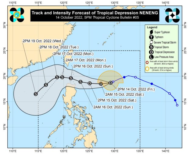
Weather updates showed that Neneng, last spotted 795 kilometers east of Calayan, Cagayan, is now packing maximum sustained winds of 55 kilometers per hour (kph) and gustiness of up to 70 kph.
It is moving west-southwest at a speed of 10 kph.
Currently, Tropical Cyclone Wind Signal No. 1 has been raised over the following areas:
- Batanes
- Cagayan including Babuyan Islands
- the eastern portion of Apayao (Luna, Santa Marcela, Flora, Pudtol), and the northern portion of Isabela (Santa Maria, San Pablo, Maconacon)
Pagasa’s recent forecast track shows that Neneng would continue moving to the northern waters of Cagayan Valley, crossing several islands within Batanes and Babuyan Islands.
It is expected to be nearest to the said islands between Sunday morning to Monday morning and would be in the tropical storm category.
Then it will continue to move westward before dipping south as it exits the Philippine area of responsibility by Monday afternoon or evening.
While there is a high chance that Neneng would only cross the waters of extreme northern Luzon, Pagasa’s cone of probability shows that Neneng may veer north or south. If it moves south, it may make a landfall over Cagayan, crossing the northernmost provinces of the Cordillera Administrative Region, and then exiting through the Ilocos Region.
If Neneng moves north, it will move closer to the Luzon Strait or near the southern areas of Taiwan.
Pagasa said residents of Batanes, Cagayan, including Babuyan Islands, Apayao, Kalinga, and Ilocos Norte can expect light to moderate with at times heavy rains from Saturday morning to afternoon.
From Saturday afternoon to Sunday afternoon, moderate to heavy rains with at times intense rains may be felt over Batanes, Cagayan including Babuyan Islands, Apayao, Abra, Kalinga, Ilocos Norte, and Ilocos Sur. Meanwhile, light to moderate with heavy rains will be experienced in Isabela and the rest of the Ilocos Region and Cordillera Administrative Region.
Pagasa warned that these conditions might cause flash floods in low-lying areas and landslides near mountain slopes.
A gale warning is also placed over the seaboards of Northern Luzon.