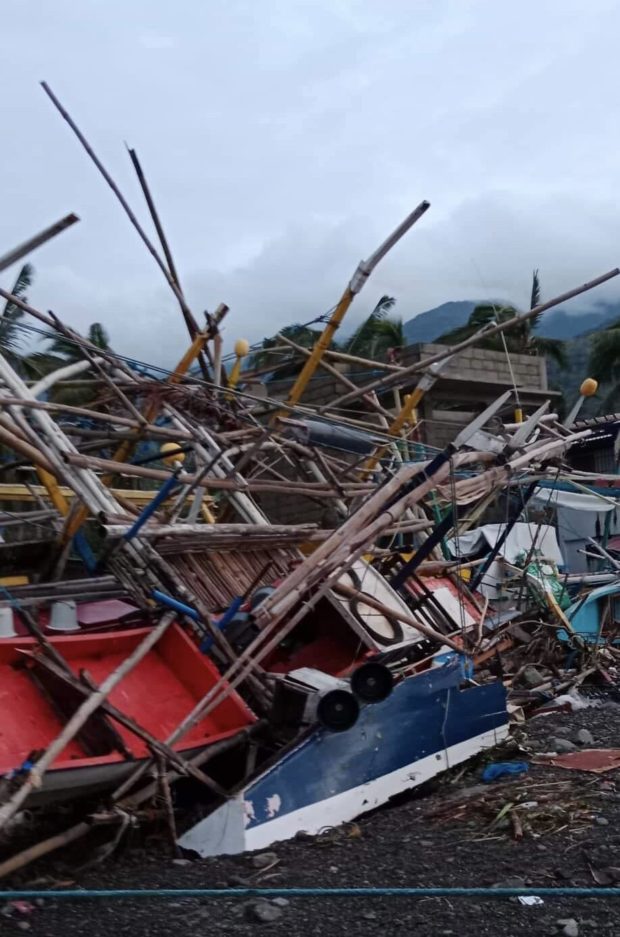
#KardingPH, which hit Luzon on Sunday (Sept. 25), destroyed boats and houses in Brgy. Paltic, Dingalan, Aurora. The typhoon made its second landfall in the said town last night, at 8:20 pm. | PHOTO: Marlon Sablaya via Kurt Adrian Dela Peña, INQUIRER.net
MANILA, Philippines — Karding (international name: Noru) intensified into a super typhoon on Sunday morning, September 25, after what the Philippine Atmospheric, Geophysical and Astronomical Services Administration (Pagasa) called a “period of explosive intensification.”
That Sunday afternoon, Super Typhoon Karding made its first landfall in Burdeos, Quezon, then in Dingalan, Aurora, bringing massive damage to homes and landscape in these two municipalities and their adjacent areas.
But what exactly is explosive intensification?
Pagasa weather specialist Ana Clauren said that in meteorology, a period of explosive intensification — also called rapid intensification — is declared when a tropical cyclone’s maximum sustained winds increase by more than 65 kilometers per hour (kph) within 24 hours.
In the case of Karding, the increase in its maximum sustained winds was at 90 kph in 24 hours.
“Very rare na nangyayari itong explosive intensification pero hindi lang ito ngayon nangyari,” Claren said in an episode of INQside Look.
(An explosive intensification rarely happens, but this was not the first time it happened.)
“May ganitong scenario sa bagyo lalo na kapag pa-landfall o malapit na siya sa lupa at favorable ‘yung environment niya to intensify ay nagkakaroon talaga ng mga rapid intensification ‘yung mga tropical cyclone,” she added.
(It usually happens when a tropical cyclone is about to make landfall and the environment is favorable for them to intensify further.)
Back in October 2020, Super Typhoon Rolly also underwent an explosive intensification, said Claren.
READ: Rolly is world’s strongest typhoon so far in 2020 — Pagasa
Claren explained that there is a higher probability of explosive intensification when the sea surface temperature is high.
“Kapag warm yung dagat ay mas maraming fuel o mas maraming energy na makukuha ‘yung isang tropical cyclone which is nagiging dahilan para mas mag-intensify o mas lumakas siya,” Claren said.
(When the sea surface temperature is high, a tropical cyclone gains more energy, which is why its rapid intensification.)
“Pangalawang dahilan ng rapid intensification ay ‘yung vertical wind shear natin na tinatawag kung saan nakikita natin sa upper level ‘yung circulation ng bagyo natin ay nasa isang lokasyon lang,” she added.
(Another reason for the rapid intensification is the vertical wind shear when the storm’s circulation is in one area only.)
National Disaster Risk Reduction and Management Council (NDRRMC) spokesperson Raffy Alejandro said Karding had left eight people dead in the country — five from Bulacan, two from Zambales, and one from Quezon.
Damage to infrastructure, meanwhile, stood at P3 million so far, according to the NDRRMC, while damage to agriculture was at around P160 million, as per the Department of Agriculture.

