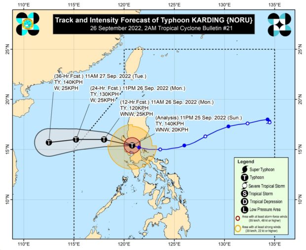

MANILA, Philippines — Typhoon Karding (internationally known as Noru) continued to weaken as it headed towards the West Philippine Sea Sunday night, according to the Philippine Atmospheric, Geophysical and Astronomical Services Administration (Pagasa).
It’s expected to exit the Philippine Area of Responsibility on Monday night.
Karding is now in the vicinity of Mayantoc, Tarlac, with maximum sustained winds of 140 kilometers per hour (kph) and gustiness of up to 230 kph.
“Afterwards, the typhoon will continue tracking generally westward over the West Philippine Sea towards Vietnam for the remainder of the forecast period. On the track forecast, it will exit the Philippine Area of Responsibility tonight,” Pagasa said in its advisory.
“Karding is forecast to continue weakening during its traverse of Luzon although it is highly likely that this tropical cyclone will remain a typhoon while crossing the landmass. Re-intensification is forecast to occur once the typhoon is over the West Philippine Sea,” the bureau added.
Pagasa downgraded the tropical cyclone wind signal (TCWS) in Metro Manila to Signal No. 2.
Here is the full list of signals due to Karding.
Signal No. 4
- Tarlac
- the northern and central portion of Zambales (Santa Cruz, Candelaria, Masinloc, Palauig, Iba, Botolan, Cabangan, San Felipe, San Marcelino, San Narciso)
- the southern portion of Pangasinan (Bautista, Alcala, Bayambang, Mangatarem, Urbiztondo, Aguilar, Bugallon, Infanta, Dasol, Burgos, Mabini, Labrador)
Signal No. 3
- the western portion of Nueva Ecija (Cuyapo, Nampicuan, Guimba, Licab, Zaragoza, San Antonio, Talugtug, Lupao, San Jose City, Science City of Muñoz, Talavera, Santo Domingo, Aliaga, Cabanatuan City, Santa Rosa, Jaen, San Leonardo, San Isidro, Cabiao, Peñaranda, City of Gapan, General Mamerto Natividad, Llanera, Quezon)
- the northwestern portion of Bulacan (San Miguel, San Ildefonso, San Rafael, Baliuag, Pulilan, Calumpit, Hagonoy, City of Malolos, Paombong, Plaridel, Guiguinto, Bustos)
- Pampanga
- the rest of Zambales
- the northern portion of Bataan (Dinalupihan, Hermosa, Orani, Samal, Morong, Abucay, City of Balanga, Bagac, Pilar)
- the rest of Pangasinan
Signal No. 2
- the central and southern portions of Aurora (Dingalan, San Luis, Maria Aurora, Baler, Dipaculao), the southern portion of Quirino (Nagtipunan)
- Nueva Vizcaya
- Benguet
- La Union
- the rest of Nueva Ecija
- the rest of Bulacan
- the rest of Bataan
- the northern portion of Quezon (General Nakar, Infanta)
Rizal - Metro Manila
- the western portion of Laguna (Santa Maria, City of Calamba, Cabuyao City, City of Biñan, City of Santa Rosa, City of San Pedro), Cavite
- the northwestern portion of Batangas (City of Tanauan, Talisay, Laurel, Tuy, Nasugbu, Lian)
Signal No. 1
- Isabela
- Mountain Province
- Ifugao
- Kalinga
- Abra
- Ilocos Sur
- the rest of Quezon, the northern portion of Occidental Mindoro (Paluan, Abra de Ilog, Mamburao, Santa Cruz) including Lubang Islands
- the northern portion of Oriental Mindoro (Puerto Galera, San Teodoro, Baco, City of Calapan, Naujan, Victoria, Pola, Socorro, Pinamalayan)
- Marinduque
- the rest of Camarines Norte
- Camarines Sur
- Burias Island
RELATED STORIES
LIVE UPDATES: Super Typhoon Karding | latest news, weather updates
LIVE UPDATES: Class suspensions due to Super Typhoon Karding