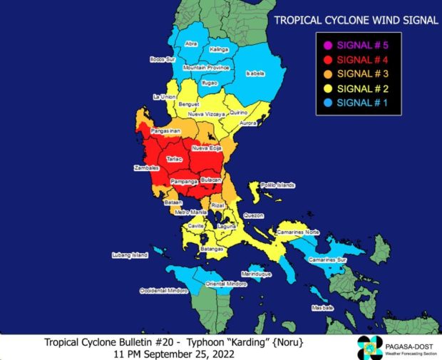
Typhoon Karding makes another landfall in Aurora
MANILA, Philippines — Typhoon Karding made another landfall, this time in Aurora, on Sunday, according to the Philippine Atmospheric, Geophysical and Astronomical Services Administration (Pagasa).
Karding is now in the vicinity of Nueva Ecija. It has maximum sustained winds of 175 kilometers per hour and gustiness of up to 290 kilometers per hour.
It is currently moving westward at 20 kilometers per hour. With Karding weakening into a typhoon category, Tropical Cyclone Warning Signal (TCWS) No. 4 is the highest possible signal.
Areas under Signal No. 4 are cautioned of typhoon-force winds with a significant to severe threat to life and property.
Pagasa has raised the following signals in these areas:
Signal No. 4
- the central and southern portion of Nueva Ecija (Llanera, Cuyapo, Talugtug, Science City of Muñoz, Rizal, Bongabon, Laur, Gabaldon, Nampicuan, Guimba, Santo Domingo, Talavera, General Mamerto Natividad, Palayan City, General Tinio, City of Gapan, Peñaranda, Santa Rosa, Cabanatuan City, Aliaga, Quezon, Licab, Zaragoza, Jaen, San Leonardo, San Isidro, San Antonio, Cabiao)
- Tarlac
- Pampanga
- Bulacan
- the northern and central portion of Zambales (Santa Cruz, Candelaria, Masinloc, Palauig, Iba, Botolan, Cabangan, San Felipe, San Marcelino, San Narciso)
- the southern portion of Pangasinan (Bautista, Alcala, Bayambang, Mangatarem, Urbiztondo, Aguilar, Bugallon, Infanta, Dasol, Burgos, Mabini, Labrador)
Signal No. 3
- the southern and central portion of Aurora (Baler, Maria Aurora, San Luis, Dingalan)
- the rest of Nueva Ecija
- Bataan
- the rest of Zambales
- the rest of Pangasinan
- the northern portion of Rizal (Rodriguez, San Mateo, Cainta, City of Antipolo, Taytay, Angono, Teresa, Tanay, Baras, Morong)
- Metro Manila
- the extreme northern portion of Quezon (General Nakar)
Signal No. 2
- the rest of Aurora
- Nueva Vizcaya
- Quirino
- Benguet
- La Union
- Cavite
- Batangas
- Laguna
- the rest of Rizal
- the northern and central portion of Quezon (Real, Infanta, Mauban, San Antonio, Tiaong, Dolores, Candelaria, Sariaya, Lucena City, City of Tayabas, Lucban, Sampaloc, Mauban, Atimonan, Pagbilao, Guinayangan, Tagkawayan, Calauag, Perez, Alabat, Quezon, Padre Burgos, Agdangan, Unisan, Plaridel, Gumaca, Lopez, Pitogo, Macalelon, General Luna, Buenavista, Catanauan) including Polillo Islands
- the western portion of Camarines Norte (Santa Elena, Capalonga, Jose Panganiban, Labo, Paracale, Vinzons) including Calaguas Islands
Signal No. 1
- Isabela
- Mountain Province
- Ifugao
- Kalinga
- Abra
- Ilocos Sur
- the rest of Quezon
- the northern portion of Occidental Mindoro (Paluan, Abra de Ilog, Mamburao, Santa Cruz) including Lubang Islands
- the northern portion of Oriental Mindoro (Puerto Galera, San Teodoro, Baco, City of Calapan, Naujan, Victoria, Pola, Socorro, Pinamalayan)
- Marinduque
- the rest of Camarines Norte
- Camarines Sur
- Burias Island
Heavy to intense with at times torrential rainfall is expected in Metro Manila, Central Luzon, Laguna, Rizal, and the northern portion of Quezon including Polillo Islands.
Meanwhile, moderate to heavy with at times intense rains will prevail over the southern portion of Metro Manila, Isabela, Nueva Vizcaya, Quirino, Kalinga, Mountain Province, Ifugao, Benguet, Cavite, Batangas, Laguna, central portion of Quezon, and the northern portion of Mindoro.
According to Pagasa’s latest Track and Intensity Forecast, Karding will weaken as it move through Luzon, though it would probably remain classified as a typhoon.
RELATED STORIES:
Marcos Jr. OKs suspension of gov’t work, classes on Sept. 26 due to Karding
LIVE UPDATES: Super Typhoon Karding | latest news, weather updates
Super Typhoon Karding makes landfall in Quezon
