Batanes back to Signal No. 1 as Typhoon Henry heads out of PAR
MANILA, Philippines — State meteorologists have lowered the Tropical Cyclone Wind Signal (TCWS) hoisted in Batanes down to Signal No. 1 as Typhoon Henry (international name: Hinnamnor) continues to move out of the Philippine Area of Responsibility (PAR) on Saturday.
Both Batanes and the northeastern portion of the Babuyan Islands (Balintag Island, Calayan Island, Camiguin Island, Didicas Island) are under Signal No. 1, as strong winds are expected to prevail within the next 36 hours, the state weather bureau’s bulletin said.
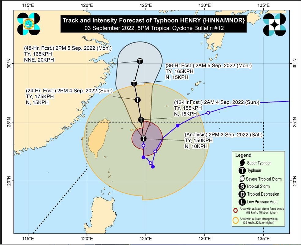
The Philippine Atmospheric, Geophysical and Astronomical Services Administration (Pagasa) said Henry is now 460 kilometers northeast of Itbayat, Batanes with maximum sustained winds of 150 kilometers per hour and gustiness of up to 185 kilometers per hour.
Pagasa said it is possible that storm signals will be removed in the next following bulletins.
Gale warnings are still raised in Batanes, Cagayan, Isabela and Ilocos Norte, said state meteorologists, who also recommended that fisherfolk should not go to sea.
Article continues after this advertisementWhile Henry is moving out of the PAR, it is dragging along the southwest monsoon or “habagat,” triggering widespread rain across central and northern Luzon, said Pagasa.
Article continues after this advertisement“Nakikita natin na naghahatak ito ng habagat, na nagkakaroon ngayon ng malawakan na kaulapan dito sa kanlurang bahagi ng gitna at hilagang Luzon, including Metro Manila area. Kaya ngayon nararanasan natin ang pag-ulan, especially here in Metro Manila,” said Pagasa weather specialist Raymond Ordinario in a press briefing.
(We see that it is dragging the habagat along, so there are widespread cloud clusters in the western portion of central and northern Luzon, including Metro Manila. It is why we are now experiencing rain, especially here in Metro Manila).
According to Ordinario, a yellow rainfall warning is raised in Zambales, Bataan, Pampanga, Bulacan and Metro Manila due to the enhanced southwest monsoon. They cautioned residents in the area to stay alert for floods.
Metro Manila, Ilocos Region, the rest of Cagayan Valley, Cordillera Administrative Region, CALABARZON (Cavite, Laguna, Batangas, Rizal, and Quezon) and the rest of central Luzon can expect cloudy skies with scattered rain showers and thunderstorms due to the combined effects of Henry and the southwest monsoon while the rest of the country can expect partly cloudy skies with isolated rain showers due to localized thunderstorms.
RELATED STORIES:
‘Henry’ to exit PAR Saturday night, but will still bring rains over Luzon
LIVE UPDATES: Super Typhoon Henry, Tropical Depression Gardo latest news