Masungi: Watershed protecting NCR under attack with impunity
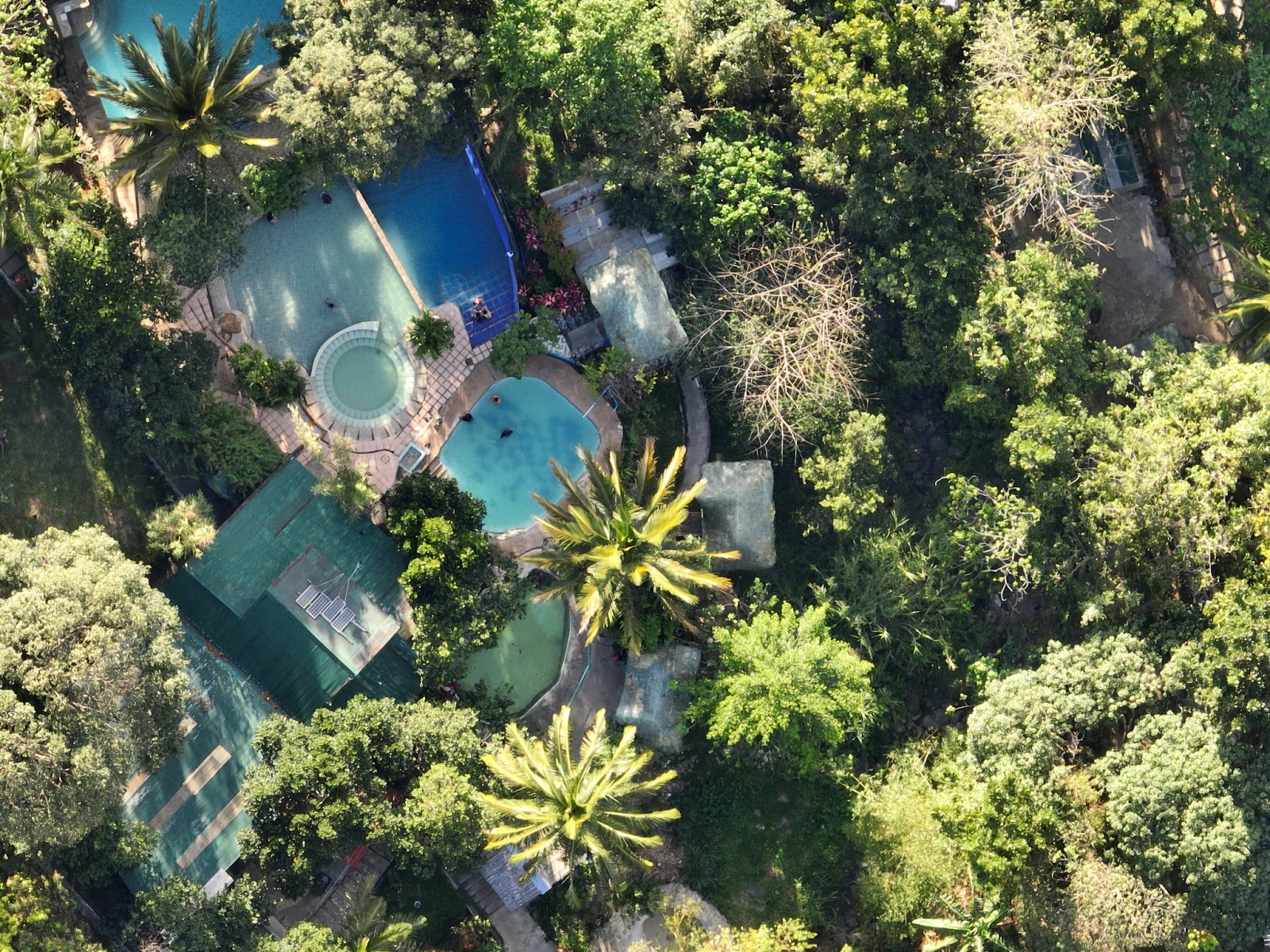
POOLS IN PROTECTED AREA. Through a drone shot, swimming pools are seen inside the Masungi Geopark Project which is part of the Upper Marikina River Basin Protected Landscape. Photo courtesy of Masungi Georeserve
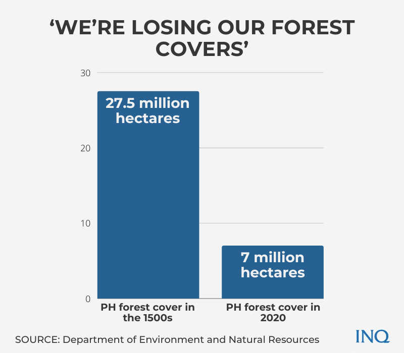
MANILA, Philippines––Environmentalists are in a race with time to save whatever forest cover is left in the Philippines—only 7 million hectares from 27.5 million hectares in the 1500s.
One of these forest sites is now known as Masuingi Georeserve, which in 1996 was dedicated to conservation and restoration of the threatened landscape of Rizal province. It was born out of a deal with the government.
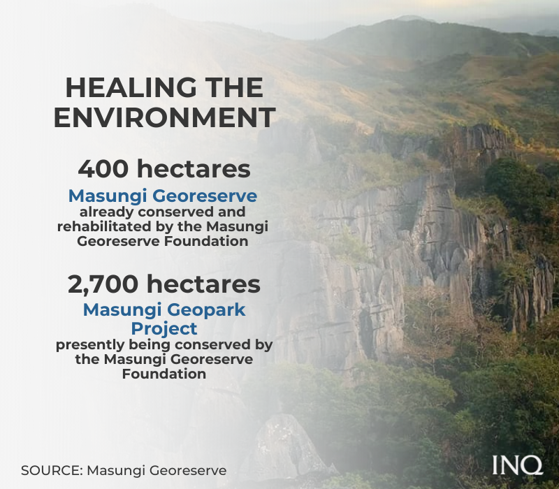
The Masungi Georeserve, which is within the rainforests of Rizal, is a 400-hectare land in the Sierra Madre Mountain Range that was hit by deforestation and massive land-grabbing activities.
Since the 2000s, the Masungi Georeserve Foundation (MGF) conserved and rehabilitated the landscape: “Trees are now growing taller, the wildlife is slowly but certainly getting richer.”
While the rock spine, which serves as a filter for essential waterways, was already preserved, the mountains on its edges “remain desperately threatened” by illegal activities.
The Global Water Partnership stressed that these illegal activities were even exacerbated by decades of institutional problems, like the lack of resources, corrupt practices and neglect.
This was the reason that in 2017, then Environment Secretary Gina Lopez asked MGF to help her preserve protected landscapes, especially the Upper Marikina River Basin Protected Landscape (UMRBPL).
The Department of Environment and Natural Resources (DENR) said the UMRBPL, with a land area of 26,126 hectares, was established through Presidential Proclamation 296 in 2001.
Anne Dumaliang, Masungi Georeserve’s managing trustee, told INQUIRER.net that they are now conserving 2,700 hectares of the UMRBPL––the Masungi Geopark Project (MGP).
Violence hits Masungi
With self-generated finances and experiences in preserving the environment, the MGF signed a landmark deal with the government to restore the MGP, but defending it from illegal activities was never easy.
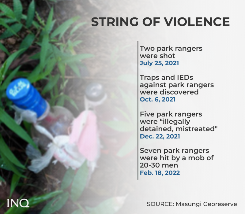
Last Friday (Feb. 18), seven park rangers, who were then eating, were violently harassed by a mob of 20 to 30 people. Dumaliang said the rangers were punched and hit with rocks. Two of the rangers were hospitalized.
Dumaliang said the mob that was responsible for the violence were individuals working for owners of “illegal resorts” inside the protected landscape.
The Feb. 18 incident was the latest in a string of violence committed against park rangers, she said, stressing the need for an end to impunity and lawlessness. “They don’t deserve this,” she said.
On July 25, 2021, two park rangers, who were then stationed in Sitio San Roque, Barangay Pinugay in Baras, Rizal, were shot––one in the head while the other in the neck.
READ: Groups seek probe of Masungi forest rangers’ shooting
Traps and improvised explosive devices (IEDs) targeted at park rangers were likewise discovered on Oct. 6, 2021. MGF said these placed rangers, the landscape, communities and even the wildlife in extreme danger.
On Dec. 22, 2021, five park rangers were “illegally detained, mistreated, and verbally abused by elements of the Baras police” on the “say-so” of an environmental offender.
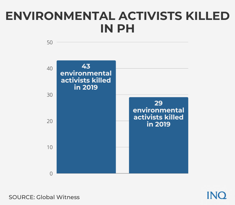
The Philippines, Global Witness said, was the deadliest place in Asia and third worldwide for environmental activists. In 2020, at least 29 land rights and environmental activists were killed in the country, just behind Colombia (60 killed) and Mexico (30 killed).
READ: PH deadliest country in Asia for environment defenders – watchdog
With 43 deaths in 2019, the Philippines was likewise the deadliest place in Asia and second worldwide for environmental activists. It was behind Colombia which had 64 killings while Brazil was third with 24 cases of killing of land rights and environmental activists.
READ: PH deadliest country in Asia, 2nd deadliest in the world, for land rights defenders — report
MGF cited data from the International Ranger Federation which said that 44 percent of “line of duty deaths” among rangers was homicide.
This, as there is only one ranger per 4,000 hectares of protected area in the Philippines, the MGF said, citing data from the United Nations Development Programme.
Law’s provisions
Right next to Metro Manila, MGF said the UMRBPL is a natural protection mechanism against severe disasters, like typhoons. This was one of the reasons MGF strives to shield it from illegal activities.
Since 1904, when the United States was still governing the Philippines, the Marikina Watershed has been “protected from settlement, entry, sale and disposition.”
The MGP, since it’s a part of the UMRBPL, is protected by the Expanded National Integrated Protected Areas System Act of 2018 (E–NIPAS), Dumaliang said.
The E–NIPAS, which amended the National Integrated Protected Areas System Act of 1992, was a piece of legislation meant to assure the ecological integrity of all protected areas, like the UMRBPL.
Section 18 (o) of the law said without clearance from the Protected Area Management Board (PAMB) and the DENR, these will be prohibited within the protected landscape:
- Construction and maintenance of any kind of structure, fence or enclosure, conducting any business enterprise
- Conduct of these activities in a way that is inconsistent with the management plan that was approved by the PAMB
The law, which recognized that all protected landscapes possess common ecological values which are essential to conserve and protect natural heritage, likewise prohibited these:
- Poaching, killing, destroying, disturbing of any wildlife
- Hunting, taking, collecting, or possessing of any wildlife
- Cutting, gathering, removing or collecting timber
- Possessing or transporting outside the protected area any timber, forest products, wildlife
- Engaging in commercial or large-scale quarrying
- Prospecting, hunting or otherwise locating hidden treasure
MGF said quarrying can completely change the landscape, destroy habitats, pollute water sources and increase risk of disasters in ecologically sensitive areas.
Resorts in protected landscape
MGF said occupying and building permanent structures in the protected landscape without clearance is a violation of the E-NIPAS Act, the Building Code and Forestry Code.
While it’s not often implemented, MGF said, the penalty for violating the law could be P5 million and six years of imprisonment: “Building permanent structures is a form of land conversion and can encourage more occupation.”
This was the reason that concerns were raised regarding the existence of resorts and permanent structures inside the UMRBPL “even without permits or titles”.
The MGF asked: “How can big swimming pool resorts exist inside a critical watershed, protected area, and wildlife sanctuary, where water is already scarce?”
When pools without clearances operate within a protected landscape, they can take precious large amounts of water from the mountains: “This will result in water loss and the decrease in clean water quality.”
“They can also be breeding grounds for parasites that can affect biodiversity,”MGF said.
“Business can be helpful to society but not at the expense of the environment and the public. There is no excuse in bullying and harming rangers who are only doing their job to protect our watershed,” it said.
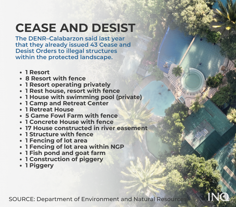
The DENR–Calabarzon said last year that it had already issued 80 Show Cause Orders and 43 Cease and Desist Orders to illegal structures within the protected landscape.
Here’s the breakdown of the violations. The DENR-Calabarzon said all of these were already given Cease and Desist Orders:
- 1 Resort
- 8 Resorts with fence
- 1 Resort operating privately
- 1 Rest house, resort with fence
- 1 House with swimming pool (private)
- 1 Camp and Retreat Center
- 1 Retreat House
- 5 Game Fowl Farms with fence
- 1 Concrete House with fence
- 17 Houses constructed in river easement
- 1 Structure with fence
- 1 Fencing of lot area
- 1 Fencing of lot area within NGP
- 1 Fish pond and goat farm
- 1 Construction of piggery
- 1 Piggery
Dumaliang said the violence, especially against park rangers, has intensified because of MGF’s resistance to the illegal activities, especially the resorts. “It’s because they know that they can no longer get away with this,” she said.
On Nov. 15, 2021 the DENR ”finally filed charges against the owner of GSB Resort” for violations of the Forestry Reform Code of the Philippines and E-NIPAS.
The MGF said the resort was found “encroaching and expanding deep into the UMRBPL and the Masungi Geopark reforestation sites [and that] it continued to construct despite multiple stop orders.”
Last Feb. 4, charges were likewise filed by the two park rangers, who were shot last year: “With our presence and your vigilance, sadly, they can longer do business as usual.”
“This is a step towards the effective enforcement of environmental laws against those who break them in bad faith and believe that they can simply get away with it,” the MGF said.
MGF likewise disproved allegations that thousands have lost their homes because of reforestation, saying that the site is located outside the sitio proper where most of the existing 150 to 200 households are located.
‘Hold DENR responsible’
Dumaliang said two of the main problems in the protected landscape are “land-grabbing and land speculation.” She said those who commit these “can’t get away with it without a level of consent from government officials.”
Last Wednesday (Feb. 23), the DENR-Calabarzon said it is already investigating the attack on the rangers, saying that it condemns violence committed against individuals who defend the environment.
READ: Be ‘proactive’ vs threats to park rangers – Masungi to DENR
However, MGF said the DENR-Calabarzon’s remarks on the Feb. 18 incident was “insensitive and misguided,” saying MGF would like to “set the record straight”.
The DENR-Calabarzon said residents told police that the park rangers allegedly had firearms with them: “This was not proven because there was no search warrant”.
It said officials of the Provincial Environment and Natural Resources Office of Rizal went to the San Roque Road that day to investigate. It said that the residents prevented the park rangers from leaving the area because “they had firearms”.
The DENR-Calabarzon said the residents told them that the firearms were allegedly inside a sack and that the violence started when the residents tried to take the guns.
However, MGF said individuals who work for resort owners conceal themselves as farmers or residents to spread lies regarding park rangers and the conservation of the protected landscape.
It said they hold the DENR “accountable” for the incidents––the Feb. 18, 2022 and the July 24, 2021 attacks on rangers––saying that they already asked the DENR countless times to prosecute, penalize, and evict those violating the law.
“It is the contractual obligation of the DENR to evict the illegal pool resorts, quarry companies, and other unscrupulous illegal occupants within the conservation project area.”
MGF said instead of heeding their call “the DENR Protected Area Superintendent and PAMBs rewarded the resorts with endorsements, despite standing Cease and Desist Orders towards their continued harmful operation.”
It said the owners were emboldened by the approvals and advise that only the MGF stands in the way of their business. This resulted in a comprehensive disinformation, hate, and violent campaign against MGF.
Dumaliang stressed that they only wanted the DENR to establish a checkpoint “to track who are the individuals in and out since July 2021.” However, she said “everything was for assessment.”
“We’re on the ground 24/7 and we know what’s happening. We will not ask for it if there’s no immediate threat against us, the park rangers, and everyone here,” she said.
The MGF said: “Clearly, had the DENR heeded our pleas and done its job, all the violence against the rangers, as well as all the irreparable injury to the watershed, could have been avoided.”
The DENR-Calabarzon told INQUIRER.net that they will hold a press conference on Monday (Feb. 28) regarding the matter.
The DENR has not yet responded to our request for comment but it said last month that it is hoping to remove illegal occupants within protected landscapes and that the UMRBPL will be a priority.
‘Still committed’
With the escalating violence against park rangers, it’s easy to cower in fear and back out, but MGF and its park rangers remain relentless in committing themselves to conserve the environment.
READ: Defending the environment in PH: Killings, attacks escalate risks
The DENR said the UMRBPL and the Kaliwa Watershed Forest Reserve “play an important role in regulating the flow of water” toward the National Capital Region (NCR).
Dumaliang told INQUIRER.net that UMRBPL is very critical not only for the communities within and on its edges because it’s also significant for Metro Manila.
“It’s really something that affects some 20 million Filipinos who rely on this watershed,” she said, stressing that illegal activities have deep impacts on the quality and amount of water, siltation of waterways, and even soil quality.
A watershed is an area of land that drains or “sheds” water into another body of water. In this case, water from the Sierra Madre flows through these areas all the way down the Pasig River, Marikina River, and Laguna de Bay:
- Antipolo
- Baras
- General Nakar
- Rodriguez
- San Mateo
- Tanay
However, the continued destruction of the forest has affected the watershed’s natural ability to hold stormwater. In 2009, when Typhoon Ondoy hit, the failure of the watershed to hold water led to one of the deadliest disasters to hit NCR.
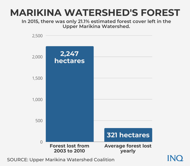
The Upper Marikina Watershed Coalition said that from 2003 to 2010, the UMRBPL lost a significant area of 2,247 hectares or an average of 321 hectares every year.
“In 2015, there was only 21.1% estimated forest cover left in the Upper Marikina Watershed. Parts of the watershed are still under threat as mining, quarrying, professional squatting, and large-scale illegal logging continues,” it said.
In 2020, when Typhoon Ulysses hit, the Advocates of Science and Technology for the People (Agham) said the degraded condition of watersheds upstream the Marikina-Pasig was also a critical factor in the floods that hit communities.
READ: Watershed degradation abetted flooding, says scientists’ group
“If a watershed is no longer healthy, when there are no trees and no vegetation, runoff water can easily travel down from the mountains and toward the rivers and other channels,” Agham said.
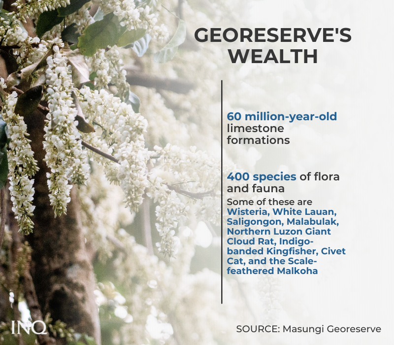
A conserved UMRBPL would likewise translate to the preservation of the Masungi Georeserve––the home of 60-year-old limestone formations and 400 species of flora and fauna.
Some of the flora and fauna that are thriving there are the Wisteria, White Lauan, Saligongon, Malabulak, Northern Luzon Giant Cloud Rat, Indigo-banded Kingfisher, Civet Cat, and the Scale-feathered Malkoha.
The Global Water Partnership said conserving the MGP will help strengthen resilience to climate changes, especially by protecting and restoring the forests in the watershed and its biodiversity.
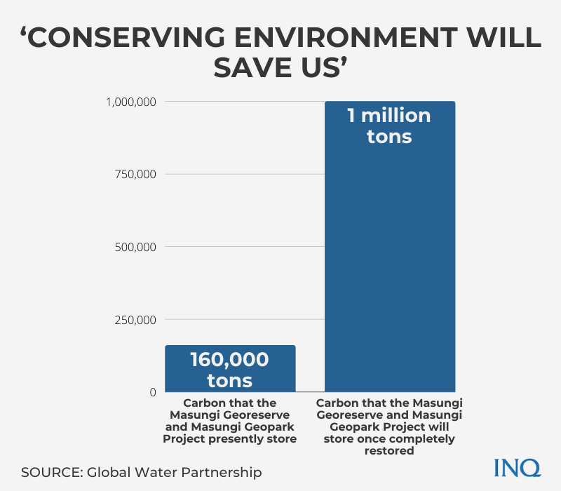
It said when landscapes are saved from threats, they act as carbon sink, stressing that so far, the Masungi Georeserve and MGP presently store an estimate of 160,000 tons of carbon or the equivalent of 66 million gallons of gasoline consumed.
“Once fully restored, the area will be able to store almost one million tons of Carbon and sequester even more every year,” it said.
