Typhoon Odette intensifies further; Signal No. 3 in 8 Vis-Min areas

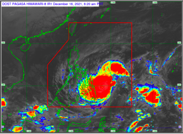
MANILA, Philippines- Typhoon Odette (international named: Rai) has intensified further while approaching the dinagat Islands and Surigao provinces, according to the Philippine Atmospheric, Geophysical and Astronomical Services Administration (Pagasa) said Thursday morning.
“Odette” was spotted at 4:00a.m. approximately 265 kilometers east of Surigao City, Surigao del Norte with maximum sustained winds of 165 kilometers per hour (kph) near the center and gustiness of up to 205 kph while moving west-northwest at 25 kph.
Tropical cyclone wind signal (TCWS) number 3 is in effect in the following areas:
-Southern Leyte
-southern portion of Leyte (Abuyog, Mahaplag, City of Baybay, Inopacan, Hindang, Hilongos, Bato, Matalom, Javier),
-Bohol
-eastern portion of Cebu (Lapu-Lapu City, Cordova, Carmen, Danao City, Compostela, Liloan, Consolacion, Mandaue City, Cebu City, City of Talisay, Minglanilla, City of Naga, San Fernando) including Camotes Islands
-Dinagat Islands
-Surigao del Norte
-northern portion of Agusan del Norte (Tubay, Santiago, Jabonga, Kitcharao)
-northern portion of Surigao del Sur (Carrascal, Cantilan, Madrid, Carmen, Lanuza, Cortes)
Destructive typhoon-force winds will prevail or are expected in these areas within 18 hours.
The following areas are under Signal No. 2:
Luzon
-Sorsogon
-Masbate including Burias and Ticao Islands, Cuyo Islands, Cagayancillo Islands,
-Southern portion of Oriental Mindoro (Bongabong, Roxas, Mansalay, Bulalacao)
-Romblon
Visayas
-Northern Samar
-Eastern Samar
-Samar
-Biliran
-rRest of Leyte,
-rest of Cebu including Bantayan Islands
-Negros Oriental
-Negros Occidental
-Siquijor
-Guimaras
-Iloilo
-Antique
-Capiz
-Aklan
Mindanao
-rest of Surigao del Sur,
-rest of Agusan del Norte
-Agusan del Sur
-Northern portion of Bukidnon (Malitbog, Impasug-Ong, Manolo Fortich, Libona, Baungon, Sumilao)
-Misamis Oriental
-Camiguin
-Northern portion of Misamis Occidental (Lopez Jaena, Plaridel, Baliangao, Calamba, Sapang Dalaga, Concepcion, Oroquieta City, Aloran)
-The extreme northern portion of Zamboanga del Norte (Rizal, Sibutad, Dapitan City, Dipolog City, Polanco, Piñan, La Libertad, Mutia)
Damaging gale- to storm force winds will prevail or are expected within 24 hours
The following areas are under Signal No. 1
Luzon
-Catanduanes
-Camarines Norte
-Camarines Sur
-Albay
-Sorsogon
-Burias Island
-Marinduque
-Southern portion of Quezon (San Antonio, Tiaong, Candelaria, Sariaya, Dolores, Lucena City, Pagbilao, Padre Burgos, Atimonan, Agdangan, Unisan, Gumaca, Plaridel, Pitogo, Lopez, Guinayangan, Buenavista, Catanauan, General Luna, Macalelon, Mulanay, San Narciso, San Andres, San Francisco, Tagkawayan, Calauag, Quezon, Alabat, City of Tayabas, Perez)
-Batangas
-Oriental Mindoro
-Occidental Mindoro
-Mainland Palawan including Balabac, Calamian, and Kalayaan Islands
Mindanao
-Northern portion of Davao Oriental (Baganga, Cateel, Boston)
-Northern portion of Davao de Oro (Laak, Mawab, Nabunturan, Montevista, Monkayo, New Bataan, Compostela)
-Northern portion of Davao del Norte (Talaingod, Santo Tomas, Kapalong, Asuncion, San Isidro, New Corella)
– rest of Misamis Occidental
-the rest of Bukidnon
-Lanao del Norte, Lanao del Sur
-Northern portion of Zamboanga del Norte (Labason, Kalawit, Tampilisan, Liloy, Salug, Godod, Bacungan, Sindangan, Siayan, Jose Dalman, Manukan, Pres. Manuel A. Roxas, Katipunan, Sergio Osmeña Sr., Gutalac, Baliguian)
-Northern portion of Zamboanga del Sur (Bayog, Lakewood, Kumalarang, Guipos, Mahayag, Dumalinao, Tukuran, Tambulig, Ramon Magsaysay, Aurora, Molave, Sominot, Tigbao, Labangan, Josefina, Pagadian City, Midsalip, Dumingag)
-Northern portion of Zamboanga Sibugay (Titay, Ipil, Naga, Kabasalan, Siay, Diplahan, Buug)
Rainfall warning
Pagasa warmed of heavy to torrential rain in the Caraga region in Mindanao, Central Visayas, Misamis Oriental, Camiguin, Southern Leyte, and Negros Occidental.
Moderate to heavy with at times intense rain is expected in Leyte, the southern portions of Eastern Samar and Samar, Zamboanga del Norte, Lanao del Sur, and the rest of Northern Mindanao while light to moderate with at times heavy rain is expected in the Bicol region, Davao Oriental, Davao de Oro, Davao del Norte, Quezon, and the rest of Visayas, Zamboanga Peninsula, and mainland Bangsamoro region.
Storm surge, gale warning
Pagasa also warned of rough sea conditions in many parts of the country.
The state weather bureau said there is a “moderate to high risk” of storm surges (3.0 m) which may cause flooding in the low-lying coasts in the following areas:
- Central Visayas
- Northern Mindanao
- Iloilo
- Guimaras
- Negros Occidental
- Eastern Samar
- Southern Leyte
- Dinagat Islands
- Surigao del Norte
- Surigao del Sur
- Agusan del Norte
- Several localities in the northern portion of Palawan including Calamian, Cuyo and Cagayancillo Islands, Antique
- The southern portion of Samar
- Leyte
- Davao Oriental
Pagasa also said that in the next 24 hours, moderate to very rough seas (1.2 to 10.0- meter waves) will prevail in areas under storm warning signals.
“These conditions are risky for all types of sea vessels. Mariners are advised to remain in port or take shelter in port until winds and waves subside,” Pagasa said.
A gale warning also remains in effect for several coastal waters not under any TCWS, specifically the seaboards of Northern Luzon, and the eastern seaboards of Central and Southern Luzon, according to Pagasa.