


Habagat, monsoon trough still whipping up rain across PH — Pagasa
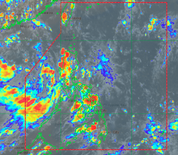
Satellite image/Himawari IR1 via Pagasa
MANILA, Philippines — The southwest monsoon or habagat, along with the monsoon trough, are still expected to bring rains over a huge part of the archipelago, state meteorologists said on Thursday afternoon.
Satellite images from the Philippine Atmospheric, Geophysical and Astronomical Services Administration (Pagasa) showed thick clouds moving in from the West Philippine Sea over Luzon and Visayas’ western provinces also on the waters southeast of Mindanao.
Due to the weather systems, areas in Palawan, Mindoro provinces, Zambales, and Bataan would see cloudy skies and possibly moderate to heavy rain showers in the coming hours. Similarly, thunderstorm activity may prevail over the rest of Luzon and Metro Manila.
Pagasa also warned that severe thunderstorms would prevail over Visayas and Mindanao, as the monsoon trough — or portions of the intertropical convergence zone (ITCZ) connected to the prevailing monsoon system — bring thick cloud bands over the said regions.
For Friday, the western parts of Luzon would still see rains, although more areas would start to have better weather conditions than the previous days.
Temperatures over Tagaytay and Puerto Princesa would still be lower than usual at 22 to 30 degrees Celsius and 25 to 31 degrees, respectively, but Laoag, Metro Manila, and Legazpi may start to warm up again at 25 to 30 degrees. Tuguegarao, on the other hand, would have something between 25 to 34 degrees.
Despite the possibility of isolated rains, Visayas and Mindanao may see warmer conditions for Friday, with Tacloban and Cebu having temperatures of 25 to 31 degrees Celsius, Iloilo with 25 to 32 degrees, Zamboanga and Davao with 24 to 32 degrees, and Cagayan de Oro with 24 to 33 degrees.
The weather bureau also said that the low-pressure area 625 kilometers west of Dagupan City is still expected to move away from the Philippine area of responsibility and approach either Vietnam or China in the next few days. It is still seen to develop to a tropical cyclone, owing to favorable conditions in the West Philippine Sea.
No gale warning has been raised yet, but sea conditions around Luzon’s western, northern, and eastern waters, plus Eastern Visayas coastal areas, would be moderate. The rest of the country’s seaboards would have a slight to moderate condition.
abc


