Storm signals up as ‘Dante‘ starts crossing Samar Island
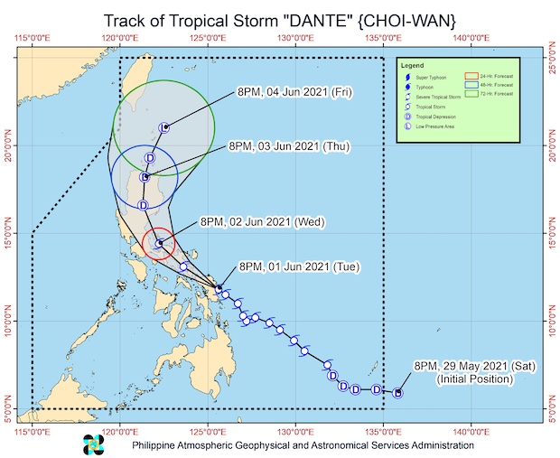
MANILA, Philippines — Tropical Storm Dante (international name: Choi-wan) on Tuesday made initial landfall in the vicinity of Sulat, Eastern Samar, and is currently crossing Samar Island, according to the 11 p.m. bulletin of the Philippine Atmospheric, Geophysical, and Astronomical Services Administration (Pagasa).
Dante was last located in the vicinity of Tarangnan, Samar, with maximum sustained winds of 65 kph and gustiness of up to 80 kph. It was moving west-northwest at 15 kph.
The storm made landfall at 8:30 p.m.
It will continue moving west-northwest or northwest until Thursday morning and is seen to make landfall in the vicinity of Sorsogon or Masbate and then cross the Bicol Peninsula before emerging over the eastern coastal waters of Quezon.
Dante is predicted to maintain its strength for the next 24 hours before weakening into a tropical depression.
“Considering the impact of land interaction and increased vertical wind shear, there is an increasing likelihood that Dante will be downgraded to tropical depression category at a much earlier time frame,” Pagasa said.
Article continues after this advertisementTropical Cyclone Wind Signal No. 2 was hoisted over the following areas:
Article continues after this advertisementLuzon
Catanduanes
Albay
Camarines Sur
Camarines Norte
the eastern portion of Romblon (Cajidiocan, Magdiwang, San Fernando), the eastern portion of Marinduque (Santa Cruz, Torrijos)
the southern portion of Quezon (Atimonan, Padre Burgos, Agdangan, Unisan, Perez, Alabat, Plaridel, Gumaca, Quezon, Calauag, Tagkawayan, Guinayangan, Lopez, Pitogo, Macalelon, General Luna, Catanauan, Buenavista, San Narciso, Mulanay, San Francisco, San Andres)
Visayas
Biliran
the northern and central portions of Samar (Santa Rita, Villareal, Daram, Talalora, Zumarraga, Pinabacdao, Calbiga, San Sebastian, Paranas, Hinabangan, San Jose de Buan, Matuguinao, Motiong, Jiabong, City of Catbalogan, Tarangnan, San Jorge, Gandara, Santa Margarita, Pagsanghan, Calbayog City, Tagapul-An, Almagro, Santo Niño)
the western portion of Northern Samar (Las Navas, Pambujan, San Roque, Silvino Lobos, Mondragon, Lope de Vega, Catarman, Bobon, San Jose, Rosario, Lavezares, Biri, Allen, Victoria, San Isidro, San Antonio, Capul, San Vicente)
“Damaging” gale-force winds will prevail or is expected within 24 hours over these areas, Pagasa said.
Meanwhile, the following areas were placed under Signal No. 1:
Luzon
Quirino
Aurora
Nueva Vizcaya
the eastern portion of Nueva Ecija (Carranglan, Pantabangan, Bongabon, Laur, Gabaldon, General Tinio, Palayan City, Rizal, General Mamerto Natividad)
the eastern portion Bulacan (Doña Remedios Trinidad, Norzagaray)
Rizal
Laguna
the eastern portion of Batangas (San Juan, Lobo, Rosario, Taysan, City of Tanauan, Santo Tomas, Lipa City, Padre Garcia, Batangas City, Ibaan, San Jose, Mataasnakahoy, Balete, Malvar)
the rest of Quezon including Polillo Islands
the rest of Marinduque
the rest of Romblon
Oriental Mindoro
Visayas
Eastern Samar
the rest of Samar
the rest of Northern Samar
Leyte
Southern Leyte
Aklan
the northern portion of Capiz (Mambusao, Sapi- An, Jamindan, Sigma, Dao, Ma-Ayon, Ivisan, Roxas City, Panay, Panitan, Pontevedra, President Roxas, Pilar, Cuartero)
the northeastern portion of Iloilo (Lemery, Ajuy, Sara, Concepcion, San Dionisio, Batad, Carles, Balasan, Estancia)
the northern portion of Negros Occidental (Manapla, Cadiz City, Sagay City, City of Escalante, Toboso, City of Victorias, Calatrava)
the northern portion of Cebu (Balamban, Cebu City, Lapu-Lapu City, Cordova, Mandaue City, Consolacion, Liloan, Compostela, Danao City, Tuburan, Asturias, Carmen, Catmon, Sogod, Tabuelan, Tabogon, Borbon, San Remigio, City of Bogo, Medellin, Daanbantayan, Toledo City, City of Talisay, Minglanilla) including Bantayan and Camotes Islands
the northeastern portion of Bohol (Getafe, Talibon, Bien Unido, Trinidad, Ubay, San Miguel, Buenavista, Danao, Inabanga, Alicia, Dagohoy, Pilar, Mabini, Pres. Carlos P. Garcia, Candijay, Anda, Guindulman)
Mindanao
Surigao del Norte including Siargao and Bucas Grande Islands
Dinagat Island
the northern portion of Agusan del Norte (Kitcharao, Jabonga)
the northern portion of Agusan del Sur (Sibagat)
the northern portion of Surigao del Sur (Cantilan, Carrascal)
Pagasa said moderate to heavy with at times intense rains are expected over Samar, Biliran, Leyte, Southern Leyte, Cebu including Bantayan and Camotes Islands, Bohol, Siquijor, Negros Oriental, northern Negros Ocidental, northeastern Iloilo, Capiz, Marinduque, Romblon, Masbate including Ticao and Burias Islands, Sorsogon, Albay, and Quezon including Polillo Islands.
Moderate to heavy rains will likewise prevail over Occidental Mindoro, Cuyo Islands, the rest of Bicol Region, and the rest of Visayas.
Meanwhile, light to moderate with at times heavy rains are also likely over Metro Manila, Central Luzon, the rest of Calabarzon, Oriental Mindoro, Calamian Islands, Camiguin, Dinagat Islands, Surigao del Norte, Agusan del
Norte, and Misamis Oriental.
Pagasa warned that scattered to widespread flooding (including flash floods) and landslides are expected
In the next 24 hours, rough to very rough seas will be experienced over the seaboards of areas under Signal No. 2 and the eastern seaboard of Caraga.
Pagasa said sea travel would be risky for small seacrafts over these waters, advising mariners without the proper experience to seek safe harbor.
Moderate to rough seas are also expected over the eastern seaboard of Davao Oriental and the remaining seaboards of areas under Signal No. 1.
Mariners of small seacrafts should take precautionary measures when venturing out to sea, the weather bureau said, adding that inexperienced mariners should avoid navigating in these conditions.