Taal Volcano Island shows signs of life

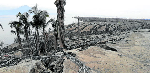
DESOLATION Taal Volcano Island in Batangas province is still a picture of desolation almost a year after the eruption wiped out communities thriving in what locals call “Pulo.” Recently, a team of scientists observed patches of revegetation in some shrubs and trees, giving them hope that life on the island will soon come back. —PHOTO COURTESY OF ED CORONEL
Under the scorching heat of the sun early this month, in an open and barren land, a team of scientists surveyed Taal Volcano Island, the first since the volcano belched tons of ash and displaced thousands of families in a steam-driven eruption nearly a year ago.
Among them were a biologist, an earth scientist, a marine life researcher, and geologists who collected samples of soil and water, as well as life forms—from insects to mollusks to soil microbes—for laboratory research.
The findings will form part of the posteruption baseline data on the volcano.
“The whole intention of the expedition was to start a scoping session [since] the current environment on the island remains risky,” said Ed Coronel, executive director of First Asia Institute of Technology and Humanities (FAITH) Botanic Gardens.
“It was like a ‘look and feel’ [expedition],” he said.
Article continues after this advertisementStreaks of gullies
From the fishing boats that they used to reach the island on Dec. 5, the scientists readily noted patches of “revegetation” from the shrubs and trees that survived the thick ash pile, particularly along the northeast and eastern portions of the island, which locals call “Pulo,” that face Balete and Tanauan City in Batangas province.
Article continues after this advertisementBut the island generally remained desolate, with streaks of ash gullies that were most likely formed by surface water runoff during the heavy rains experienced in recent months.
The gullies of hardened volcanic ash and soil rose 1.5 meters to 2 m, and climbing over them was difficult, Coronel said.
“It’s hard to move around. You have to retrace [a gully] all the way back,” he said.
The scientists did not see a single horse around or a farm animal that might have survived months after the eruption, but “a dog or two” were there that some erstwhile residents might have brought back to the island when they fished on the lake anew.
There were other signs of life, like the raptors that biologists in the team surmised to have begun returning to Pulo after the eruption.
“Among the directions of the research is to understand the succession and revegetation posteruption. It is in terms of how life grows back in an area where a [volcanic] explosion occurred,” Coronel said.
There were many initial suppositions, but one was that the earth’s movement might have affected Taal Lake’s water, which rose and submerged as far as 20 m of Pulo’s shoreline.
A concrete structure, once Barangay Calawit’s tourism office, now stands on the waterline, Coronel said.
The crater lake, at the center of this complex volcano that gave Taal its name “a lake within the lake,” is the color of milky deep emerald, an indication that the water has high sulfur content, he said.
Donated land
FAITH Botanic Gardens is a foundation of the private FAITH Colleges in Tanauan City.
In 2019, a private donor transferred 176 hectares of land to the foundation in Barangay Calawit on Pulo, which is under the jurisdiction of Balete town.
Property titling and decades of human settlement on the 2,300-ha Pulo surrounded by Taal Lake has long been a political and economic issue in Batangas.
The eruption on Jan. 12 prompted the national government to finally declare Pulo a “no man’s land,” barring the return of close to 5,000 people who had lived off farming, fishing and tourism by offering horseback rides on the island.
Knowing full well that the foundation could not build any structure on the island, Coronel, in an online interview, raised the question: “What do we do with this land?”
Live laboratory
The eruption made scientific research “quite interesting,” if not more relevant than ever, he said.
FAITH plans to use the property as a “live laboratory” for faculty and students, according to Coronel.
The foundation organized the expedition and brought together scientists and experts from various fields and universities to survey the island as part of the “Agham ng Bulkang Taal” (Science of Taal Volcano) program.
Among the 18-member team were Lillian Rodriguez of the University of the Philippines (UP) Terrestrial Research of Ecology and Evolution Laboratory, Mario Aurelio of the UP National Institute of Geological Sciences, Alexander Young of the UP Institute of Environmental Science and Meteorology, and the University of Santo Tomas College of Science Dean Rey Donne Papa. Coronel said what the expedition offered were fresh and early data to establish the “benchmark” and fill in data gaps to fully understand the volcano. INQ