Tropical depression nearing PH to likely affect areas hit by Quinta once it hits land
MANILA, Philippines — Areas still reeling from Typhoon Quinta’s (international name Molave) rage will see more rain once the tropical depression currently spotted outside the Philippine area of responsibility (PAR) hits land in the Bicol Region or Eastern Visayas.
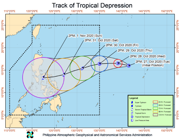
Based on the state weather bureau’s bulletin issued 5 p.m., Tuesday, the tropical depression was still over the Pacific Ocean – some 2,125 kilometers east of Central Luzon, packing maximum sustained winds of 45 kilometers per hour (kph) and gustiness of up to 55 kph.
It is moving in a north-northwest direction at a speed of 15 kph, but track predictions from the Philippine Atmospheric, Geophysical and Astronomical Services Administration (Pagasa) showed it might start swerving to the southwest direction by Wednesday afternoon and keep its track when it enters the PAR by Thursday afternoon.
And despite various possibilities, Pagasa believes the still-unnamed weather disturbance might make a landfall over the Bicol Region or Eastern Visayas this coming weekend.
As the tropical depression moves towards the Philippine Sea, Pagasa said it is expected to gather strength and become a tropical storm by Saturday, October 31, and then a severe tropical storm prior to landfall. Pagasa also said it is negotiating a pattern similar to Quinta’s track that it is likely to cross the Southern Luzon seas towards the West Philippine Sea.
Article continues after this advertisementBut for now, Pagasa said, the tropical depression has no effect yet on the country’s weather systems. It said parts of Luzon, including Central Luzon, Southern Luzon, Bicol Region, and Metro Manila, are forecast to experience gradual warming of the climate.
Article continues after this advertisementAccording to Pagasa, Metro Manila and Tuguegarao will have temperatures ranging from 25°C to 32°C on Wednesday while Legazpi will feel it between 25°C and 33°C.
The same conditions will apply to Visayas and Mindanao, Pagasa noted, with the exception, however, of the Zamboanga Peninsula as it may still be affected by Quinta’s trough and cloud bands.
In Cebu, temperatures are predicted to be around 25°C to 32°C on Wednesday while it may range from 25°C to 33°C in Iloilo, Tacloban, and Davao.
Meantime, Pagasa kept its gale warning over Luzon’s entire western seaboard – from Ilocos Region, Central Luzon, down to Southern Luzon and Palawan; plus the northern Luzon areas and Cagayan’s eastern seas.
This means small boats in these areas are barred from sailing because sea conditions will be rough to very rough.