Pagasa: LPA outside PAR won’t develop into storm
Source: Pagasa / DOST
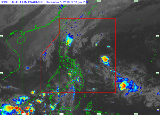
MANILA, Philippines – The low pressure area (LPA) seen outside the Philippine area of responsibility (PAR) is not expected to develop into a storm, the Philippine Atmospheric, Geophysical and Astronomical Services Administration (Pagasa) said on Thursday afternoon.
The state weather bureau, however, said the northeast monsoon or Amihan and the cold front may still bring rain to the eastern and northern parts of Luzon, even as Tropical Depression Tisoy has moved outside PAR.
“‘Yong LPA na ating mino-monitor sa labas ng Philippine area of responsibility, hindi po natin inaasahan na ito ay magiging bagyo at sa mga darating na araw ay posible na rin po itong malusaw,” Pagasa weather specialist Ana Clauren said in the latest weather update.
(The LPA we are monitoring outside the Philippine area of responsibility, we are not expecting it to turn into a storm and it may disintegrate in the coming days.)
“Samantala ‘yong mga nagdadala ng pag-ulan dito sa eastern sections ng Northern at Central Luzon dulot po ‘yan ng tail end of a cold front, kaya expect po natin within 24 hours ang maulan na panahon. Ang Amihan naman ang nakaka-apekto sa ibang bahagi pa,” she added.
Article continues after this advertisement(Meanwhile, rains in the eastern sections of Northern and Central Luzon are caused by the tail end of a cold front, that’s why we expect rains within 24 hours. The Amihan also affects other areas.)
Article continues after this advertisementMeanwhile, the weather condition in Metro Manila and the rest of the country is expected to be generally fair, except for isolated thunderstorms every afternoon.
Tisoy (International name: Kammuri), which has ceased to have any effect on the country’s weather system, is also expected to be a low pressure area in the coming days.
A gale warning is still raised in various Luzon coastlines, including the shores of Batanes, Cagayan, Ilocos Norte, Ilocos Sur, La Union, Pangasinan, Isabela, Aurora, Zambales, Bataan, Quezon province, Camarines Norte, Camarines Sur, Catanduanes, Palawan, and Occidental Mindoro.
“Ibig sabihin po n’yan hindi po muna natin pinapayagan pumalaot ‘yong ating mga kababayang mangingisda pati na rin ‘yong mga gumagamit ng maliliit na sasakyang pandagat dahil magiging maalon at maaring umabot sa 4.5 meters ang ating wave height,” Clauren explained.
(It means we would not allow fisherfolk and those using small sea crafts to leave the shores because we are expecting rough seas with waves as high as 4.5 meters.)